Seismic Hazards and Magnitude (AQA A-Level Geography): Revision Notes
Seismic Hazards and Magnitude
What are earthquakes?
Earthquakes are one of the most powerful natural hazards on Earth. They occur because the Earth's crust is constantly in motion, which creates a gradual build-up of pressure between masses of rock moving in different directions. When this accumulated stress is suddenly released, parts of the surface experience violent ground movement that typically lasts from just a few seconds up to around 30 seconds. However, in exceptional cases like the Boxing Day earthquake of 2004, the shaking continued for nearly six minutes.
Definition: Earthquake
An earthquake is the result of stress build-up in the Earth's crust. When this pressure is suddenly released, the surface experiences a period of intense shaking motion caused by seismic waves radiating outwards from the source.
Nature and distribution of earthquakes
Understanding focus and epicentre
When pressure is released within the Earth's crust, this release occurs at a specific point beneath the surface. This point of origin is called the focus (sometimes referred to as the hypocentre). The point on the Earth's surface directly above the focus is called the epicentre. Understanding this distinction is crucial because the depth of the focus significantly affects the intensity of damage experienced at the surface.
The relationship between focus and epicentre is key to understanding earthquake impacts. Seismic waves radiate outward from the focus in all directions, but the epicentre represents the point on the surface where these waves first reach populated areas. This is why damage is typically most severe at or near the epicentre.
Types of earthquake focus
Earthquakes are categorised into three types based on the depth of their focus:
-
Shallow focus (0-70 km deep): These earthquakes tend to cause the greatest damage and are responsible for approximately 75% of all earthquake energy released globally. Because they occur closer to the surface, the seismic waves have less distance to travel before reaching populated areas.
-
Intermediate focus (70-300 km deep): These occur at moderate depths and typically cause less surface damage than shallow focus events.
-
Deep focus (300-700 km deep): These are the deepest earthquakes and generally cause the least surface damage due to the greater distance seismic waves must travel.
Critical Concept: Shallow Focus Dominance
Shallow focus earthquakes (0-70 km deep) account for 75% of all earthquake energy released globally and cause the most severe damage due to their proximity to the surface. This is why understanding focus depth is essential when assessing earthquake risk.
Where earthquakes occur
The overwhelming majority of earthquakes occur along plate boundaries. The most powerful earthquakes are typically associated with destructive margins, where plates collide and one is forced beneath the other. At conservative margins, where plates slide past each other horizontally, the boundary is characterised by transform faults. These faults experience sudden differential movement that produces earthquakes.
Perhaps one of the most famous examples of this is the San Andreas Fault in California. This represents the boundary between the North American and Pacific plates. In reality, the San Andreas system is actually a broad, complex zone containing numerous fractures within the crust rather than a single fault line.
Earthquakes away from plate boundaries
Some earthquakes occur away from major plate boundaries. For instance, in February 2018, an earthquake with an intensity of 4.6 on the Mercalli Scale was felt across much of Wales and south-west Britain. An earthquake of this magnitude occurs somewhere on mainland Britain approximately every four years.
Regional Variation in Earthquake Frequency
This frequency is considerably lower than in more tectonically active regions. For comparison, according to the Meteorological Agency of Japan (JMA), Japan experiences approximately 2,000 earthquakes every year - highlighting the dramatic differences in seismic activity between regions along active plate boundaries and those in more stable continental interiors.
Human-induced earthquakes
It has been suggested that certain human activities could trigger minor earthquakes. Building large reservoirs can put pressure on underlying rocks. Similarly, in recent times, the process of fracking (hydraulic fracturing of rock to release gas) has raised concerns. A series of earthquakes, the largest measuring 2.9 on the moment magnitude scale, were recorded near a fracking site close to Blackpool, Lancashire. This prompted authorities to stop drilling operations pending a thorough review of safety procedures.
Magnitude and frequency of earthquakes
The moment magnitude scale
The magnitude of earthquakes can be measured in various ways. The most widely used measurement today is the moment magnitude scale, which measures the size of an earthquake in terms of the total energy released, expressed as Mw.
Critical Concept: The Moment Magnitude Scale
The moment magnitude scale (Mw) is a logarithmic scale that measures earthquake size based on energy released. An increase of one step on the scale corresponds to approximately 32 times the amount of energy released. Two steps represent an increase in energy of 1,000 times.
This logarithmic nature is crucial to understand. It means that the difference between a magnitude 6 and magnitude 7 earthquake is not simply "one unit more" - it represents 32 times more energy. Similarly, a magnitude 8 earthquake releases 1,000 times more energy than a magnitude 6 event.
The calculation of moment magnitude involves several factors including the rigidity of the rock affected, the distance the rock moved, and the total area where movement occurred.
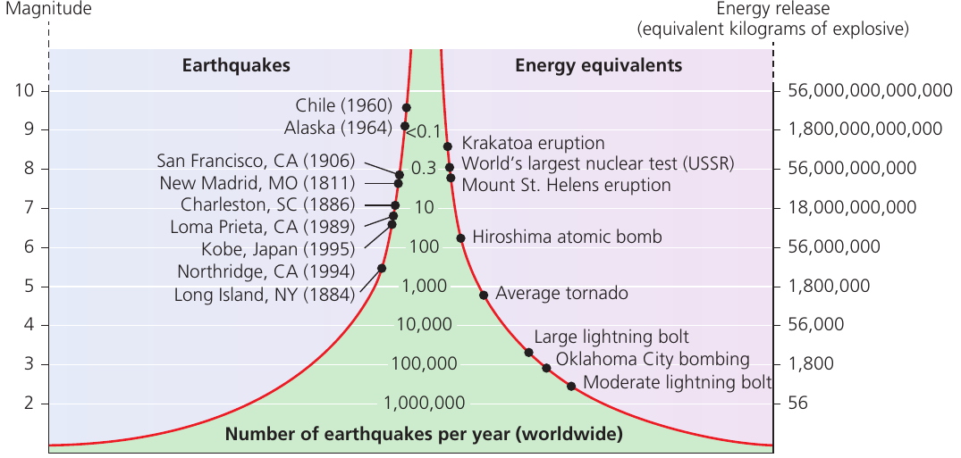
The chart above illustrates the relationship between earthquake magnitude, energy release, and frequency of occurrence worldwide. Notice how there is an inverse relationship - smaller earthquakes are far more common than large ones, but the larger events release exponentially more energy.
Intensity vs magnitude
Whilst magnitude provides a quantitative measure of energy released at the earthquake's source, intensity offers a qualitative assessment of the strength of ground shaking and its effects at a specific location.
Key Distinction: Magnitude vs Intensity
- Magnitude: A single quantitative value for each earthquake measuring total energy released
- Intensity: A qualitative measure that varies by location, describing the strength of shaking and observable effects
This means one earthquake has one magnitude value, but many different intensity values depending on where you measure the effects.
The Mercalli scale
The Mercalli scale measures earthquake intensity and its observable impacts on people, buildings, and the environment. Unlike magnitude, which has a single value for each earthquake, intensity varies depending on location - areas closer to the epicentre typically experience higher intensity.
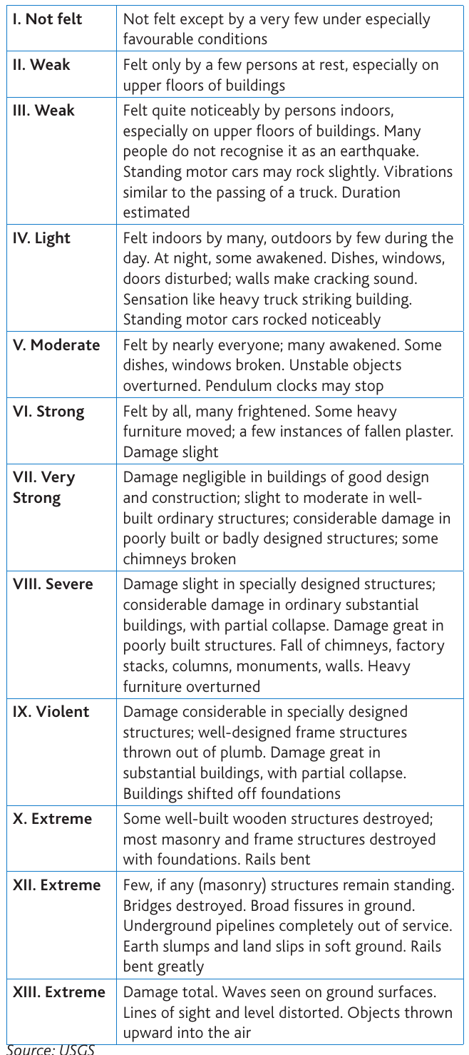
The Mercalli scale ranges from I (Not felt) through to XIII (Extreme). It describes the severity of shaking in terms that are observable and measurable, such as whether people feel the tremor, whether objects fall, and the extent of structural damage to buildings.
Seismic records enable earthquake frequency to be observed, but these records only extend back to 1848 when instruments capable of recording shock waves were first developed. For earlier events, we must rely on historical records to understand the date and effects of earthquakes.
The impacts of seismic events
Very few people are actually killed directly by the ground shaking itself if they are standing in an open area. Instead, people are harmed by what earthquakes do to their surroundings - collapsing buildings and infrastructure (roof collapse), the sea (tsunamis), and slopes (landslides). Some effects occur immediately, whilst others develop over a longer period and depend heavily on the area's capacity to recover.
Primary effects
The initial, or primary, hazard of an earthquake consists of the immediate impacts caused by the seismic event itself.
Ground shaking is the most obvious primary effect. This is caused by shock waves travelling through the crust from the focus up to the surface, then radiating outwards in all directions. In extreme cases, these waves behave more like sea waves, with a clear up-and-down motion observable at the surface. The severity of shaking depends upon several factors:
- The magnitude of the earthquake
- Its depth (distance from the epicentre)
- The distance from the epicentre
- Local geological conditions
Worked Example: Ground Amplification in Mexico City (1985)
The Mexico City earthquake of 1985 provides a striking demonstration of how local geology amplifies seismic effects.
The Situation:
- The shock waves that hit Mexico City were amplified several times by the ancient lake sediments upon which the city is constructed
- These soft sediments acted like a resonator, increasing the amplitude of seismic waves
The Result:
- Ground motion in Mexico City measured five times greater than in outlying districts built on different soil foundations
- This amplification led to catastrophic building collapses in the city center
- Demonstrates that distance from epicentre alone doesn't determine damage - local geology is equally critical
Ground rupture represents another significant primary hazard. This is the visible breaking and displacement of the Earth's surface, typically occurring along the line of a fault. Ground rupture poses a major risk to large engineered structures such as dams, bridges, and nuclear power stations, which can suffer catastrophic damage if the ground beneath them suddenly shifts or breaks apart.
Secondary effects
Secondary effects are those that occur as a consequence of the primary earthquake impacts.
Understanding Secondary Effects
Secondary effects develop after the initial earthquake but can be equally or more devastating than primary effects. They include soil liquefaction, landslides, avalanches, and tsunamis. Understanding these hazards is crucial because most earthquake deaths result from secondary effects rather than ground shaking itself.
Soil liquefaction occurs when soils with a high water content are violently shaken, causing them to lose their mechanical strength and behave like a fluid rather than a solid.
Case Study: Palu Soil Liquefaction (Indonesia, 2018)
The Palu (Indonesia) earthquake of 2018 caused extensive soil liquefaction within and close to the city.
Effects observed:
- Soils lost their solid structure and began flowing like liquid
- Mudflows submerged many buildings
- In one dramatic case, an entire village was completely engulfed by liquefied soil
- Buildings that remained structurally intact were still destroyed by being carried away or buried
Landslides and avalanches result from slope failure triggered by ground shaking.
Case Study: Gorkha Earthquake Landslides (Nepal, 2015)
Following the Gorkha earthquake in Nepal in 2015, scientists from NASA documented extensive slope failures across the region.
Key findings:
- 4,312 landslides occurred between the earthquake in April and the onset of monsoon rains in June
- Most were comparatively small rockfalls and debris avalanches
- Some were large enough to block entire valleys
- In the Langtang valley, the village of Langtang was almost completely buried by debris
This demonstrates how secondary effects can continue for weeks after the initial earthquake, particularly in mountainous terrain.
Tsunamis are giant sea waves generated by shallow-focus underwater earthquakes involving vertical movements of the sea bed. They can also be triggered by landslides entering the sea. These waves can travel vast distances across ocean basins at high speeds, causing devastating impacts on coastal communities far from the earthquake's epicentre.
Critical Understanding: Why Secondary Effects are Deadly
Most earthquake casualties result from secondary effects rather than ground shaking itself:
- Building collapse (triggered by shaking but technically a secondary effect)
- Tsunamis can affect coastlines thousands of kilometres away
- Landslides can continue for days or weeks after the initial event
- Liquefaction can destroy buildings that survived the initial shaking
This is why earthquake preparedness must address both primary and secondary hazards.
Remember!
Key Points to Remember:
-
Shallow focus earthquakes (0-70km deep) cause the most damage and account for 75% of all earthquake energy released globally.
-
The moment magnitude scale is logarithmic - each step up represents 32 times more energy released, and two steps equal 1,000 times more energy.
-
Magnitude measures energy released (a single value for each earthquake), whilst intensity measures the strength of shaking (varies by location using the Mercalli scale).
-
Primary effects (ground shaking and ground rupture) occur immediately, whilst secondary effects (soil liquefaction, landslides, and tsunamis) happen as consequences of the initial earthquake.
-
Most earthquake deaths result from secondary effects such as building collapse, tsunamis, and landslides rather than from ground shaking itself.