Case Study: Shifting Dunes and Aeolian Processes (AQA A-Level Geography): Revision Notes
Case Study: Shifting Dunes and Aeolian Processes
Understanding aeolian processes in desert environments
Wind plays a powerful role in shaping desert landscapes through aeolian processes. These are the ways that wind picks up, transports, and deposits sand particles, creating the distinctive dune formations we associate with deserts. Understanding how quickly sand moves and in which direction is crucial for communities living near active dune systems.
In both hot deserts and coastal environments, the same fundamental processes operate. This means we can study coastal dunes in the UK to understand the same wind-driven processes that affect settlements in places like the Sahara Desert.
By studying these processes through careful fieldwork and measurement, geographers can predict dune movement and help protect vulnerable settlements.
Case study 1: Nouakchott, Mauritania - when dunes threaten settlements
Geographical setting
The Sahel region forms a semi-arid to extremely dry belt stretching from east to west across Central Africa, lying along the southern edge of the Sahara Desert. This transition zone experiences challenging environmental conditions where sand dunes can pose significant threats to human settlements.
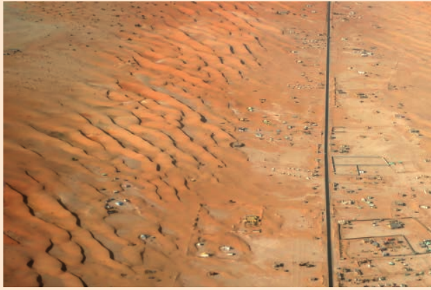
Nouakchott serves as the capital city of Mauritania and sits on the western edge of the Sahara. The city's location makes it vulnerable to the movement of sand dunes across the landscape.
The threat of advancing dunes
Many people imagine that deserts rapidly expand, with vast sand seas quickly swallowing huge areas of land. This dramatic image is largely a misconception. However, it is well documented that sand dunes do move over time, and they have advanced towards Nouakchott on several occasions, creating genuine concern for the city's residents.
What scientists need to measure to assess dune threats:
For communities worried about encroaching dunes, scientists need to gather specific information:
- What is the current size of the dune systems?
- How fast are the dunes advancing?
- What is the actual nature and scale of the threat?
These questions can only be answered through systematic measurements and data collection to establish the rate of sand movement and understand the aeolian processes at work.
Measuring aeolian processes: fieldwork techniques
Fieldwork aims and transferable skills
Geography students can use various techniques to gather field data that measures and quantifies aeolian processes in sand dune environments. Whilst we cannot easily visit shifting sand dunes in hot deserts like the Sahara, we can study coastal sand dunes much closer to home. The same fundamental techniques apply to both environments, allowing us to understand how wind transports sediment and shapes landforms.
Study location: The Drigg Coast, Cumbria
A fieldwork investigation was conducted along a stretch of dunes on The Drigg Coast, located on the Cumbrian coast in northwest England. This accessible location provides an excellent opportunity to observe and measure aeolian processes in action.
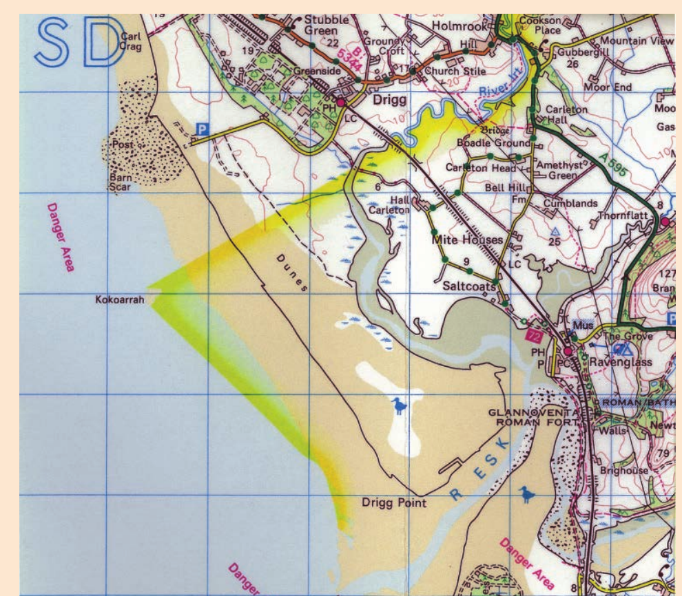
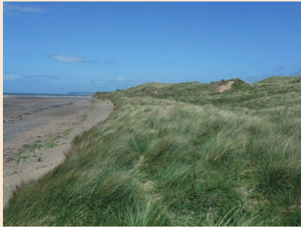
The dunes at Drigg feature typical coastal characteristics, including marram grass vegetation that helps stabilise the sand. Despite being a UK coastal environment rather than a hot desert, the wind-driven processes here mirror those affecting settlements like Nouakchott.
Measuring wind speed and direction
To investigate how wind speed and direction affect the rate of sediment movement, students need to collect data at regular intervals along a stretch of sand dunes.
Equipment needed:
- Anemometer (measures wind speed)
- Weather vane (shows wind direction)
- Stopwatch
- Small plastic sheets
- Known quantity of sand
- Data recording sheets
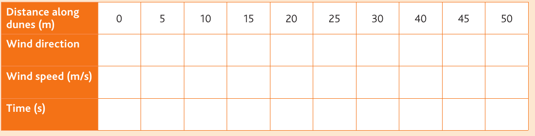
Data Collection Method: Measuring Wind and Sediment Transport
Step 1: Position yourself at regular 5-metre intervals along the dune front.
Step 2: At each collection point, measure and record the wind speed using the anemometer.
Step 3: Note the wind direction using the weather vane.
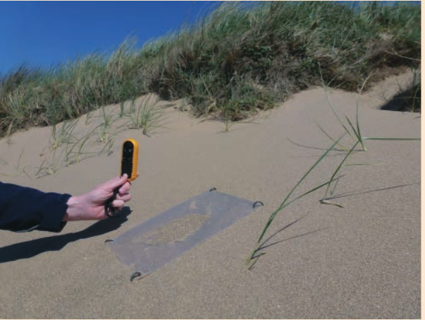
Step 4: Place a measured amount of sand on a small plastic sheet secured to the sand surface.
Step 5: Use a stopwatch to record how long it takes for all the sand to be transported away by the wind.
This gives a practical measure of the sediment transport rate at that specific location.
Recording sediment transport rates
The data collected should include:
- Distance along the dunes (in metres)
- Wind direction (compass bearing)
- Wind speed (in metres per second, )
- Time taken for sand removal (in seconds)
Systematic sampling approach
Why systematic sampling matters:
Using systematic sampling, wind direction and speed can be recorded at 5-metre intervals along the entire dune front. This approach ensures:
- Even coverage of the study area
- Consistent data collection methodology
- Reliable results for analysis
The measured amount of sand placed on each plastic sheet allows students to calculate transport rates at each point.
Recording the time taken for complete sand removal at all sampling points builds a comprehensive dataset. This primary data can then be analysed to identify which parts of the dunes are experiencing the most rapid sand transport. By knowing the quantity of sand used and the full length of the dunes, students can calculate or estimate the total amount of sand being moved along the dune system.
Measuring dune profiles
Understanding dune shape and steepness helps explain sediment transport patterns. The slope angle or profile of dunes may influence how easily sand moves.
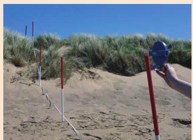
Method for Measuring Dune Profiles:
Step 1: Place a measuring tape at the high tide mark on the beach.
Step 2: Extend the tape perpendicular to the beach, running inland across the dunes in a straight line.
Step 3: Position ranging poles at 2-metre intervals along the tape measure.
Step 4: Use a clinometer (angle-measuring device) to measure the angle between each pair of poles.
Result: This allows you to construct an accurate cross-section of the dune profile.
Analysing the data
Once collected, this fieldwork data can be used to construct cross-sections through the dunes. Correlation analysis can then examine whether there is a relationship between the steepness of the dunes and the rate of sand transportation recorded in the earlier investigation.
This combination of measurements helps build a complete picture of how aeolian processes shape and move sand dunes, providing insights that apply to both coastal UK environments and hot desert settings like Nouakchott.
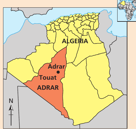
Case study 2: Desertification in the Touat region, Algeria
Location and geographical context
The Touat region (also known as Adrar) lies in southern Algeria, in the northern Sahara Desert. This area demonstrates how traditional sustainable practices can come under pressure, leading to desertification.
Key Definition: Desertification
Desertification is the degradation of land in arid and semi-arid regions, often resulting from human activities and climate variations. It leads to the loss of biological productivity and threatens the sustainability of ecosystems that support human communities.
Traditional oasis agriculture
For centuries, communities in the Touat region developed efficient and sustainable irrigation systems that made clever use of the limited water supplies found in oases. These groundwater sources allowed local populations to survive and even thrive in the hostile arid conditions.
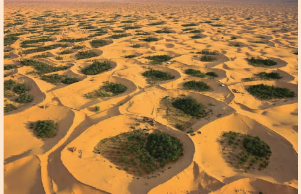
Small settlements traditionally grew around these precious water sources, practising small-scale agriculture. Farmers used ground water carefully to sustain themselves through growing crops and maintaining small-scale farming operations. This traditional approach worked in harmony with the desert environment's limitations, creating a sustainable way of life adapted to extreme aridity.
Causes of desertification pressure
In recent decades, the water supplies, soil quality, and overall sustainability of these oasis systems have come under serious threat. Three main pressures have combined to create desertification risk:
Population growth
Algeria's population is growing at almost 2% per annum, meaning the number of people doubles approximately every 35 years. Life expectancy has increased significantly, reaching 78 years for females and 76 years for males by 2020. This population growth places increased demand on limited desert resources, particularly water and agricultural land.
Intensification of agricultural production and over-cultivation
Farmers have moved towards monoculture approaches, focusing on high-yielding modern seed varieties rather than diverse traditional crops. Some of these modern varieties are grown as cash crops for export, prioritising economic returns over local food security.
This agricultural intensification involves heavy use of chemical fertilisers and modern machinery. Whilst these techniques can boost short-term yields, they often damage soil quality and sustainability over the longer term. Over-cultivation exhausts the soil and degrades its structure.
Water stress from unsustainable extraction
The Critical Water Crisis:
Most critically, the introduction of modern powerful water pumps has transformed water use in the region. These pumps can remove huge quantities of water directly from groundwater stores, which is then used for jet irrigation systems spread across the agricultural fields.
However, this creates an impossible equation:
- Water is being extracted far faster than it can be naturally replenished
- The Touat region experiences extremely high evaporation rates
- The region receives only an average of 50 millimetres of rainfall per year
The mathematics simply do not work - the oases are losing water far more quickly than nature can replace it.
Impacts and implications for sustainability
The combination of these three pressures threatens the long-term sustainability of the entire oasis system. As water tables drop, soil degrades, and population continues to grow, the traditional balance that allowed communities to survive in this harsh environment for centuries is being undermined.
Traditional Resilience and Adaptation:
Close to the town of Adrar in the Touat region, people have turned to traditional approaches to improve their resilience to the arid climate. They are working to adapt to and mitigate the impacts of desertification pressures on their precious and limited water supply. These sustainable solutions draw on centuries of local knowledge about living successfully in desert conditions.
Remember!
Key Points to Remember:
-
Aeolian processes are wind-driven processes that transport sand and shape desert landforms. Measuring these processes helps predict dune movement and protect vulnerable settlements like Nouakchott.
-
Fieldwork techniques for studying dunes include:
- Measuring wind speed and direction at regular 5-metre intervals
- Recording sediment transport rates using timed sand removal
- Measuring dune profiles with tape measures and clinometers at 2-metre intervals
-
The Touat region of Algeria demonstrates how traditional sustainable oasis agriculture is threatened by three key pressures:
- Population growth (~2% per annum)
- Agricultural intensification with modern techniques
- Unsustainable groundwater extraction
-
Water stress is the critical issue in the Touat oases, where powerful pumps extract water faster than the mere 50mm of annual rainfall can replenish it, threatening centuries-old sustainable practices.
-
Data analysis from dune fieldwork allows geographers to:
- Identify areas of rapid sand transport
- Calculate total sediment movement
- Examine correlations between dune steepness and transport rates