Deserts as Natural Systems (AQA A-Level Geography): Revision Notes
Deserts as Natural Systems
Introduction to desert systems
Desert environments are distinctive landscapes that can be understood and studied through a systems approach. This means viewing deserts as complex environments where various elements interact and influence one another. Deserts are found in arid and semi-arid regions, primarily around mid and low latitudes near the tropics. These areas receive minimal rainfall and support sparse or no vegetation, making them sparsely populated due to their extreme climatic conditions.
Understanding deserts as systems helps us see how different components work together to create and shape these unique landscapes. Each element of the desert system - from energy inputs to landform outputs - plays a role in the overall functioning of the environment.
Hot deserts as open systems
Desert landscapes operate as open systems, which means energy and materials can enter and exit the system freely. This is a fundamental concept for understanding how deserts function and evolve over time.
An open system allows continuous exchange of energy and matter with its surroundings. Unlike closed systems, deserts are constantly receiving inputs from external sources and releasing outputs to the environment. This dynamic exchange is what drives the formation and evolution of desert landscapes.

Inputs
Inputs are the energy and materials that enter the desert system from external sources:
- Solar energy - the sun provides enormous amounts of energy that drives processes in the desert
- Precipitation - although limited, rainfall enters the system and contributes to weathering and erosion
- Wind - moving air brings energy into the system and drives many desert processes
Components (stores)
Components are the features and materials that exist within the desert system:
- Erosional landforms and landscapes - features created by the wearing away of rock and sediment, such as rock pedestals and desert pavements
- Depositional landforms and landscapes - features created by the accumulation of sediment, such as sand dunes and desert plains
These landforms act as stores, temporarily holding sediment and materials within the system.
Flows and transfers
Flows represent the movement and processes occurring within the desert system:
- Erosional processes - weathering, abrasion and deflation break down rock and move sediment
- Wind and water transport - these agents carry sediment from one location to another within the desert
These processes link the different components together, moving materials between erosional and depositional areas.
Outputs
Outputs are materials and energy that leave the desert system:
- Sediment removal - water and wind carry sediment out of the desert environment
- Energy re-radiation - the desert surface releases energy back to space, particularly at night when temperatures drop dramatically
The clear skies typical of desert environments allow large amounts of energy to escape back into space. This is why deserts can experience extreme temperature variations between day and night, with scorching days followed by cold nights.
Dynamic equilibrium in deserts
Dynamic equilibrium occurs when the inputs and outputs of a system are balanced, creating a state of overall stability even though individual components continue to change.
When a desert system is in dynamic equilibrium, the overall character of the landscape remains relatively stable. However, this doesn't mean the desert is static - processes continue to operate and individual landforms may change. The key is that changes in one part of the system are balanced by changes elsewhere.
If one element of the system changes, the entire system responds. For example, if increased sediment is blown into the desert but no corresponding increase occurs in sediment removal, desert landforms will change and the equilibrium will be disrupted. The system may then adjust to establish a new equilibrium state.
Feedback mechanisms in desert systems
Feedback occurs when a change in one part of the system triggers further changes that either amplify or reduce the original change. Understanding feedback is crucial for understanding how deserts evolve and how human activities can impact desert environments.
Positive feedback and desertification
Desertification provides an excellent example of positive feedback in desert systems. Positive feedback amplifies changes, creating a cycle that reinforces itself and leads to increasing degradation.
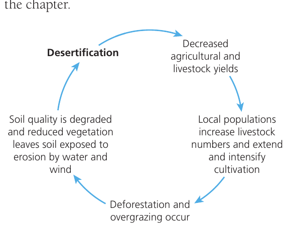
Worked Example: The Desertification Feedback Loop
Understanding how positive feedback operates in desert systems:
Stage 1: Initial degradation Desertification begins, causing soil quality to decline and vegetation to reduce, leaving soil exposed to wind and water erosion
↓
Stage 2: Declining productivity Reduced vegetation and soil quality lead to decreased agricultural and livestock yields for local communities
↓
Stage 3: Intensified pressure Local populations respond to declining yields by increasing livestock numbers and extending cultivation to try to maintain production levels
↓
Stage 4: Further degradation Increased livestock leads to overgrazing, whilst expanded cultivation causes deforestation, creating more degradation
↓
Cycle repeats → Returns to Stage 1 with even greater degradation
This creates a vicious cycle where each stage leads to the next, and degradation feeds back to cause further degradation. Breaking this cycle requires intervention to disrupt the feedback loop.
The desertification cycle demonstrates how human responses to environmental stress can inadvertently worsen the original problem. This is a classic example of positive feedback - where the system's response amplifies rather than counteracts the initial change.
Global distribution of hot deserts
Deserts and their margins cover more than one-fifth of Earth's surface. Hot desert environments and their surrounding semi-arid areas show distinctive distribution patterns across the globe.
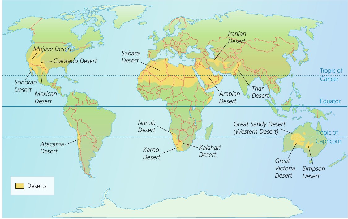
General patterns
Hot deserts are not randomly distributed. They generally form parallel belts running north and south of the Equator, concentrated in mid and low-latitude locations around the Tropics of Cancer and Capricorn. These locations are influenced by global atmospheric circulation patterns that create zones of high pressure and descending dry air.
Northern hemisphere deserts
Almost all hot desert landscapes in the northern hemisphere are positioned towards the western sides of continents. Major northern hemisphere desert regions include:
- North America - the Mojave Desert, Sonoran Desert, Great Basin, Colorado Desert, Chihuahuan Desert and Mexican Desert
- North Africa - the Sahara Desert (the world's largest hot desert) and Somali-Ethiopian deserts in the Horn of Africa
- Asia - the Arabian Desert, Iranian Desert and Thar Desert, stretching from the Red Sea through the Middle East to Pakistan and India
The western location pattern in the northern hemisphere is linked to the presence of cold ocean currents along western coastlines and the influence of subtropical high-pressure systems. These factors combine to create extremely dry conditions.
Southern hemisphere deserts
In the southern hemisphere, hot desert areas are distributed differently:
- South America - the Atacama Desert along the Pacific coast
- Southern Africa - the Namib, Kalahari and Karoo deserts
- Australia - the Great Sandy Desert (also called Western Desert), Great Victoria Desert, Simpson Desert and other arid areas covering much of the continent's interior
Factors influencing desert location
The distribution of deserts reflects several geographic factors including distance from moisture sources, the presence of cold ocean currents, rain shadow effects from mountain ranges, and the influence of high pressure zones in subtropical latitudes. The concept of continentality - where distance from the coast influences climate - helps explain why many interior continental areas experience arid conditions.
Key terminology
Arid - the climate of an area that receives less than 250 mm of precipitation per year. These are the core desert areas with extreme water deficits.
Semi-arid - the climate of an area that receives between 250 and 500 mm of precipitation per year. These areas form transition zones around desert margins.
Desert - an arid environment receiving very low levels of rainfall, characterised by sparse vegetation and distinctive landforms created by wind and water action.
Aridity index - the ratio between precipitation (P) and potential evapotranspiration (PET). This provides a more sophisticated measure of how dry an area is by comparing water inputs with potential water losses.
Continentality - the impact of increasing distance from the coast on the climate of an area. Continental interiors tend to be drier as moist air from oceans loses moisture before reaching these regions.
Water balance - the relationship between the annual precipitation received and the amount of water lost to potential evapotranspiration. Desert areas have a negative water balance, with potential evaporation far exceeding precipitation.
Remember!
Key Points to Remember:
-
Desert landscapes function as open systems with inputs (solar energy, precipitation, wind), components (landforms), flows (erosion and transport processes), and outputs (sediment and energy removal)
-
Deserts exist in a state of dynamic equilibrium where inputs and outputs balance, but if one element changes, the entire system adjusts and landforms may alter
-
Positive feedback in desertification creates a vicious cycle where degradation triggers responses that cause further degradation, demonstrating how desert margins can expand
-
Hot deserts are concentrated in parallel belts around the Tropics of Cancer and Capricorn in mid and low-latitude locations, with northern hemisphere deserts mainly on western continental margins
-
Understanding deserts as systems helps explain how these distinctive landscapes form, function and respond to environmental changes and human activities