Water and Aridity Index (AQA A-Level Geography): Revision Notes
Water and Aridity Index
Understanding aridity index
Deserts are commonly understood as arid environments that receive minimal rainfall. The classification of these dry regions depends on how much precipitation they receive annually:
- Hot deserts: Less than 250 mm of rainfall per year
- Semi-arid regions: Between 250-500 mm of rainfall per year
However, classifying deserts is more complex than just measuring rainfall. Desert environments can be:
- Hot or cold
- Sandy or rocky
- Foggy or sunny
- Barren or sparsely vegetated
They exist at various altitudes and in both coastal and continental interior locations. The key factor linking all definitions is the lack of water, which leads us to the concept of water balance.
Water Balance
Water balance compares the mean annual precipitation (P) received with the mean annual potential evapotranspiration (PET).
Potential evapotranspiration (PET) is the amount of water that could be lost from the soil through plant transpiration and direct evaporation from the ground.
Calculating aridity
The aridity index is calculated by comparing precipitation to potential evapotranspiration. This gives us a standardised way to classify dry environments.
Understanding the Aridity Index Formula
The relationship between precipitation and evapotranspiration determines the aridity index:
- When : aridity index (not a desert)
- When : aridity index (desert conditions)
Categories of arid environments
Hot deserts and their margins are classified into three categories based on the aridity index:
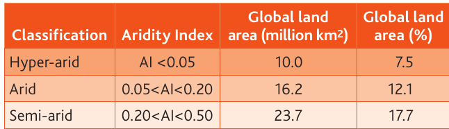
Key categories
Hyper-arid environments (aridity index less than 0.05):
- Represent 10.0 million km² of land
- Cover 7.5% of global land area
- The driest desert regions
Arid environments (aridity index 0.05 to less than 0.20):
- Cover 16.2 million km²
- Represent 12.1% of global land area
- Typical hot desert regions
Semi-arid environments (aridity index 0.20 to less than 0.50):
- Extend across 23.7 million km²
- Cover 17.7% of global land area
- Desert margin regions with slightly more moisture
Global Desert Coverage
Together, these three categories of arid environments cover a significant portion of Earth's land surface. The semi-arid regions alone account for nearly one-fifth of all land area, while hyper-arid regions, though the driest, cover the smallest percentage.
Global distribution patterns
The Sahara Desert has the highest aridity levels globally. Other notably arid regions include:
- Arabia
- East Africa
- Australia
- South Africa
Less arid (but still dry) regions include the Thar Desert and the deserts of North America.
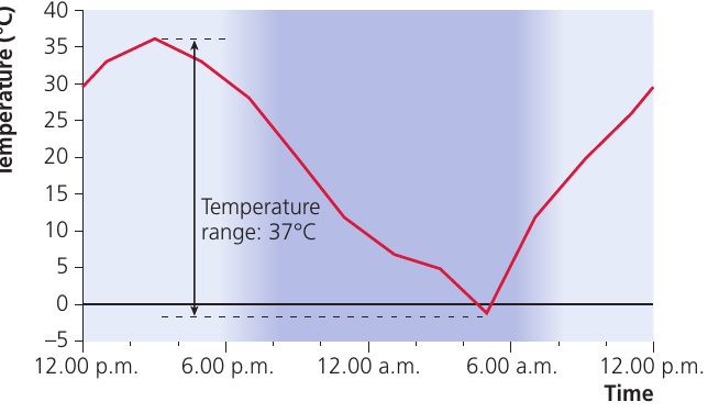
Climate characteristics of hot deserts
Hot deserts remain warm throughout the year with very high summer temperatures. However, their climates are characterised by extremes in temperature variation.
Temperature variations
Hot desert climates experience two types of temperature variation:
Annual variation: The difference between the hottest and coldest months each year
Diurnal variation: The difference between daytime and night-time temperatures
Extreme daytime temperatures
Hot deserts experience exceptionally high temperatures during the day:
- Daytime temperatures commonly exceed 30°C
- Many locations regularly reach 45-55°C
- The highest temperature ever recorded was 57.7°C at Al Azizyah in Libya in 1922
Why Are Daytime Temperatures So Extreme?
These extreme temperatures occur because:
- Humidity levels are very low in hot deserts
- Subtropical latitudes have extremely low cloud levels
- Clear skies allow significant amounts of solar radiation (insolation) to reach the surface
- Hot deserts receive almost twice the insolation of more humid latitudes closer to the Equator
Night-time temperature drops
The cloudless skies that create high daytime temperatures also explain the large diurnal (daily) range. At night, temperatures drop very rapidly because:
- Hot deserts lose heat twice as quickly at night as more humid latitudes
- Without cloud cover, heat escapes rapidly into the atmosphere
- Night-time temperatures often drop below 0°C
- Records of around -18°C are not uncommon
Extreme Diurnal Temperature Ranges
This creates extreme diurnal ranges:
- Typically over 30°C difference between day and night
- Some places experience ranges exceeding 40°C
These dramatic temperature swings occur because the lack of cloud cover allows both rapid heating during the day and rapid cooling at night.
Semi-arid climate patterns
Semi-arid regions at desert margins also remain warm year-round with hot, dry summers:
- Average temperatures around 21-27°C
- Temperatures rarely exceed 38°C
- Night-time temperatures remain cool, around 10°C
As distance from the tropics increases towards the poles, semi-arid areas experience greater seasonality. This means:
- Annual temperature ranges increase in hot deserts
- Desert margins show huge variations in temperature
- Poleward semi-arid areas are significantly colder than those on the equatorial side
Regional temperature variations
Temperature patterns in hot desert areas vary considerably around the globe due to geographical differences:
Coastal deserts (e.g., the Atacama) have:
- Cooler temperatures
- Less extreme temperature ranges
- Influence from ocean currents
Continental interior deserts have:
- Hotter daytime temperatures
- More extreme temperature ranges
- Less moderating influence
Key Points to Remember:
- The aridity index compares precipitation to potential evapotranspiration to classify desert environments
- Three categories exist: hyper-arid , arid , and semi-arid
- Hot deserts experience extreme temperature variations both daily (diurnal) and annually
- Clear, cloudless skies cause both very high daytime temperatures (45-55°C) and rapid heat loss at night (below 0°C)
- The diurnal range in hot deserts can exceed 30-40°C due to the lack of cloud cover
- Desert temperature patterns vary by location, with coastal deserts being cooler and less extreme than continental interior deserts