Land Use Changes Affect the Water Cycle (AQA A-Level Geography): Revision Notes
Land Use Changes Affect the Water Cycle
Introduction
Human activities that modify the land surface have significant impacts on how water moves through the hydrological cycle. These land use changes alter key processes including infiltration, evapotranspiration, surface runoff, and groundwater storage. Understanding these effects is essential for managing water resources and flood risk.
The main land use changes affecting the water cycle include:
- Agricultural practices (ploughing, terracing, grazing)
- Urbanisation and impermeable surface creation
- Deforestation
- Artificial drainage systems
- Water abstraction from aquifers and surface water
Agricultural land management
Agricultural activities modify the landscape in various ways, each affecting water movement differently. These changes can either increase or decrease the speed at which water reaches river channels.
Ploughing impacts
When farmers plough their fields, they create furrows that run down slopes. These act as artificial stream channels that rapidly transport water downhill. This increases surface runoff and produces flashier hydrographs with higher peak discharges. Additionally, ploughing on wet soils can create impermeable layers in the subsoil called plough pans. These compacted zones prevent water from percolating deeper into the soil, forcing more water to flow across the surface instead.
Plough Pan Formation
A plough pan is a compacted layer of soil created beneath the ploughed zone that restricts water infiltration and root penetration. This impermeable layer forces water to travel as overland flow rather than infiltrating into deeper soil layers.
Terracing effects
In contrast to ploughing, terracing on hillsides slows water movement down slopes. By creating horizontal platforms on steep terrain, terraces intercept flowing water and allow more time for infiltration. This subdues the hydrograph by reducing peak discharge and extending lag time.
Grass crops and infiltration
Planting grass crops has beneficial effects on the water cycle. The dense root systems of grasses improve soil structure, creating spaces that enhance infiltration. This allows more water to enter the soil rather than flowing across the surface, resulting in subdued hydrographs with lower peak flows.
Livestock grazing
When large numbers of animals graze on small areas, their hooves compact the soil surface. This soil compaction reduces infiltration capacity, forcing more water to travel as overland flow. The effect is particularly pronounced in areas with high stocking densities or during wet conditions when soils are vulnerable to damage.
Urbanisation and impermeable surfaces
The expansion of urban areas represents one of the most dramatic land use changes affecting the water cycle. Cities and towns replace natural, permeable surfaces with impermeable materials like concrete, asphalt, and roofing.
Impact on water movement
Urban growth creates extensive impermeable surfaces including roads, pavements, car parks, and buildings. These surfaces prevent infiltration entirely, forcing rainfall to become immediate surface runoff. Settlements are specifically designed with drainage systems to remove water as quickly as possible from human activity areas, directing it towards the nearest river.
Hydrograph changes
The conversion of rural land to urban areas fundamentally alters the river's response to rainfall. This is clearly demonstrated by comparing hydrographs before and after urbanisation.
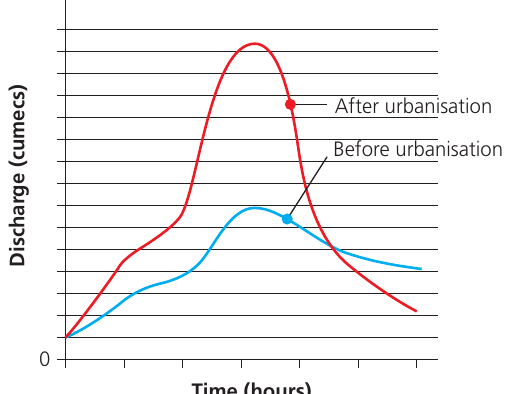
After urbanisation, the hydrograph shows several key changes:
- Higher peak discharge: More water reaches the channel because infiltration is reduced
- Shorter lag time: Water arrives at the river more quickly via drainage systems and overland flow
- Steeper rising limb: The rapid concentration of water creates a sharp increase in discharge
- Flashier response: The river responds more dramatically and quickly to rainfall events
Increased Flood Risk from Urbanisation
These hydrograph changes significantly increase flood risk. The problem is particularly acute because many urban areas have been built on floodplains, where flooding naturally occurs. The combination of higher peak discharges, shorter lag times, and faster water delivery creates dangerous flooding conditions.
Case study context: London
London provides a striking example of progressive urbanisation. According to a 2016 Royal Horticultural Society report, half of London's front gardens had been paved over, representing a 36 per cent increase over ten years. This continuing loss of permeable surfaces exacerbates urban flooding issues.
Flood management responses
Some soft engineering flood management schemes attempt to reduce flashiness by increasing interception and infiltration. Afforestation (planting trees) in catchments slows water movement to river channels and subdues hydrograph changes.
Deforestation
Removing forests has profound effects on the water cycle at multiple scales. Tropical South America, which contains the world's largest continuous tropical rainforest, provides important examples of these impacts.
Why deforestation matters
The Amazon region is environmentally critical because it:
- Supports exceptionally high biodiversity
- Generates over a quarter of the world's river discharge
- Influences regional and global climate patterns
Despite its importance, over 10 per cent of the rainforest has been converted to cattle pasture and agriculture in the last 50 years, driven by demand for beef and sugar cane for ethanol production.
Effects on the water cycle
When forests are removed, replacement vegetation typically has shallower roots and fewer leaves. This means the new vegetation:
- Uses less water than the original forest
- Returns less water to the atmosphere through evapotranspiration
- Allows more water to run off the land surface
- Increases stream flow
The magnitude of these changes depends on several factors including the extent of deforestation, local rainfall amounts, topography, soil characteristics, and how the land is used after clearance.
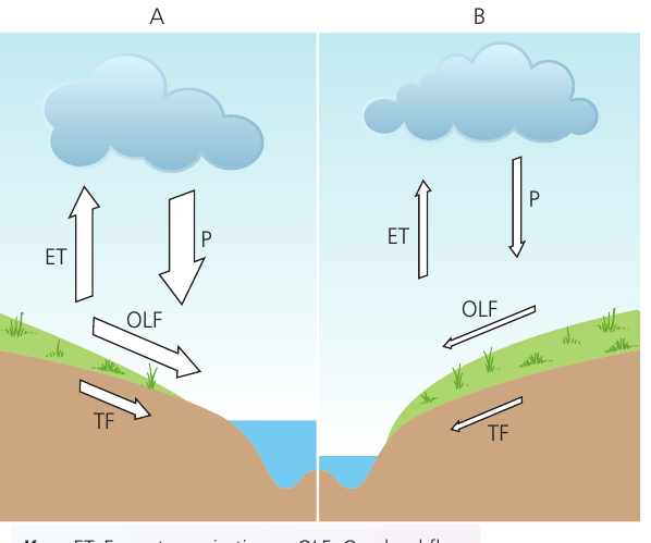
Localised deforestation impacts
When deforestation affects a small area, the changes remain relatively contained. Under natural forest conditions, high precipitation is balanced by substantial evapotranspiration. The dense vegetation intercepts rainfall, and most water reaching the forest floor infiltrates into the soil, travelling slowly to the river through throughflow. Overland flow is minimal.
Localised Deforestation: Water Cycle Changes
After localised deforestation, evapotranspiration decreases because replacement vegetation is less dense with smaller leaf areas and shallower roots. This means less water returns to the atmosphere.
Although precipitation remains the same, the reduced vegetation cover increases overland flow and throughflow because there is less interception and the new vegetation extracts less water from the soil.
Result: This leads to increased discharge and flashiness, potentially causing localised flooding.
Extensive deforestation and feedback mechanisms
When deforestation is widespread across large areas, positive feedback loops can develop within the basin's hydrological system. The key mechanism is atmospheric:
- Reduced evapotranspiration means less water vapour enters the atmosphere from the deforested area
- Less atmospheric water vapour means less water is available for precipitation
- Rainfall levels fall across the region
- The water that does arrive leaves quickly via river channels rather than recycling through the forest ecosystem
Atmospheric Feedback: The Drying Cycle
Once this feedback cycle is established, there is less water vapour available for precipitation, further reducing rainfall. Although some water still travels through river channels, the overall flow may be reduced. This creates a self-reinforcing cycle of drying that affects entire catchment areas.
The atmospheric feedback effects are not confined to areas where deforestation has occurred - changes spread unevenly throughout the Amazon basin through atmospheric circulation patterns.
Scale and atmospheric circulation
Rivers of all sizes experience impacts when deforestation is extensive. Studies indicate that the effects become significant when 20-50 per cent of a basin is deforested, with major increases in impact when 50-100 per cent of an area loses its forest cover. These changes operate at the local scale initially but affect entire river systems when deforestation is extensive.
Soil drainage systems
Subsurface drainage is an agricultural practice that removes excess water from soil to improve growing conditions. Understanding both the benefits and environmental consequences is important.
How tile drainage works
Subsurface drainage involves installing a network of perforated tubes 60-120 cm below the soil surface. These tubes, traditionally called 'tiles' because they were originally made from short clay pipes, now typically consist of corrugated plastic with small holes or gaps.
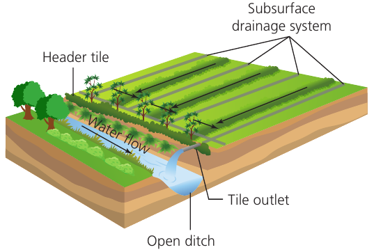
Drainage System Operation
Water seeps into the drainage tubes through the perforations or through small cracks between adjacent tiles. This lowers the water table to the depth of the tile system. Over several days, excess water drains away, but once the water table drops to the elevation of the tiles, no additional drainage occurs through them. In the UK, most tile drainage systems have no flow between June and October.
Advantages of soil drainage
Agricultural drainage provides multiple benefits that improve farm productivity and land management:
-
Improved soil structure: Creating a better-drained soil profile makes it more friable (crumbly) and easier to work. This enhanced structure allows greater root penetration, enabling crops to access water and nutrients from deeper soil layers.
-
Enhanced microbial activity: Better aeration creates favourable conditions for microorganisms that decompose organic matter. This increases the rate at which organic material breaks down into humus, and mineralises plant nutrients into forms that crops can absorb. The improved air supply also supports root cell respiration.
-
Warmer soils: Increased aeration helps soils warm more quickly. This can enable earlier sowing of seeds with improved germination rates.
-
Reduced compaction: Heavy farm machinery can work on drained land without causing excessive compaction or increasing overland flow.
-
Higher stocking densities: More animals can graze on drained land without compacting the soil excessively.
-
Economic returns: Research by Ohio State University demonstrated that every dollar spent on drainage returned between $1.20 and $1.90 in increased crop yields and improved farm efficiency when calculated over multiple growing seasons.
Disadvantages of soil drainage
Despite these benefits, artificial drainage creates several environmental problems:
Environmental Costs of Drainage
-
Increased flood risk: Drainage systems artificially accelerate throughflow in soils. Water reaches watercourses much more quickly than before drainage was installed, increasing the likelihood of flooding downstream. This faster water delivery also increases the range of river flows. Historically, before extensive UK floodplain drainage in the eighteenth century onwards, rivers were more navigable than today because annual flow regimes were more consistent and even.
-
Wind erosion vulnerability: Drained topsoil can become too dry if not properly protected. Soil loss through wind erosion has been extensively documented for sandy and peaty soils in eastern and middle England, particularly in arable fields of the East Midlands and East Anglia. Mean wind erosion rates are estimated at 0.1 to 2 tonnes per hectare per year, though maximum values for individual fields can be one or two orders of magnitude higher.
-
Eutrophication risk: Water draining from fields carries nutrients into local watercourses, enriching ponds and streams with nitrogen and phosphorus. This causes algae and higher forms of plant life to grow excessively fast. The resulting population explosion disrupts the balance of organisms in the water and degrades water quality.
One strategy to mitigate these problems is controlled drainage. This maintains high water tables during the off-season when crops are not growing. The elevated water table increases denitrification rates (a process converting nitrate to harmless nitrogen gas that is released to the atmosphere in spring), thereby reducing nitrate loss to the environment.
Water abstraction
Water abstraction occurs when demand for water exceeds the amount naturally available during a specific period. This situation arises frequently in areas with low rainfall, high population density, and/or intensive agricultural or industrial activity.
Groundwater dependency in Europe
Throughout much of Europe, groundwater serves as the dominant source of fresh water. In numerous locations, water is being extracted from underground aquifers faster than rainfall can replenish it. This over-exploitation has severe consequences:
- Sinking water tables
- Empty wells requiring deeper, more expensive pumping
- Higher pumping costs
- Reduced reliability of rivers (many river flows are maintained during dry seasons by springs that cease when water tables fall)
- Degradation of groundwater-dependent ecosystems such as lakes and wetlands
- In coastal regions, intrusion of saltwater from the sea into freshwater aquifers
Saline Intrusion in Coastal Areas
This saline intrusion is widespread along Mediterranean coastlines in Italy, Spain and Turkey, where tourist resort water demands are a major factor driving over-abstraction. In Malta, most groundwater can no longer be used for domestic consumption or irrigation because of saline intrusion, forcing the country to invest in expensive desalination plants.
Over-abstraction in chalk stream systems
Some of the most acute over-abstraction problems occur in chalk stream systems. Up to 95 per cent of flow in these streams is derived from underground aquifers. The catchments of chalk streams provide underground reservoirs of generally high quality groundwater suitable for public water supply abstraction.
Chalk Stream Degradation
Intensive abstraction has dramatically reduced flow in many chalk streams. In some cases, sections of these important rivers have completely dried up, particularly during dry summers when public demand peaks.
This creates both ecological and economic impacts on local communities who cannot fish or enjoy river views due to encroaching vegetation. Some local residents must undergo other recreational activities as their river-based leisure options disappear.
Case study: Water abstraction from the chalk of southern England
The chalk aquifer of southern England is recharged by rainfall landing on exposed chalk hills of the North and South Downs and the Chilterns. This natural recharge process follows a seasonal pattern.
Seasonal recharge patterns
Normally, recharge occurs during winter months when potential evapotranspiration is low and soil moisture deficits are negligible. Groundwater amounts vary seasonally:
- Levels rise from autumn through winter into spring
- During summer months, potential evapotranspiration generally exceeds rainfall
- Soil moisture deficits build up throughout summer
- Little or no percolation reaches the water table in summer
Variable abstraction patterns
In summer, water continues to leave the chalk aquifer from springs and through abstraction from boreholes. However, this pattern is not uniform because rainfall varies both temporally and spatially. Rivers fed by groundwater from chalk aquifers experience intermittent sections. These streams, often called 'bournes', naturally characterise chalk downlands. The positions of springs feeding these rivers shift throughout the year, being at greater altitude in winter and spring. When one or more dry years occur and effective rainfall recharge is low, these rivers can dry up completely.
Acute problems with over-abstraction
The most severe over-abstraction issues affect chalk stream systems where up to 95 per cent of water flow derives from underground aquifers. These catchments provide crucial underground water storage of generally high quality suitable for public supply.
Though abstraction has dramatically reduced flow in many streams, and completely dried sections of important rivers (particularly during dry summers when demand is highest), this also generates economic impacts on local communities through inability to fish, enjoy river views due to encroaching vegetation, or participate in other recreational activities.
Case study: Water abstraction in the London Basin
The London Basin provides an example showing both the problems of over-abstraction and successful management strategies for recovery.
Geological context
The chalk layers form a syncline (downfold) beneath the London area, with uplands of the Chilterns to the northwest and the North Downs to the southeast.
Precipitation on these exposed chalk hills naturally soaks into the porous chalk where it is stored and released at springs in contact with either Greensand or Palaeogene rocks.
Historical abstraction patterns
Throughout history, London's water has been abstracted from wells and boreholes penetrating down to the chalk. During the nineteenth century and first part of the twentieth century, the chalk-basal sands aquifer experienced increasingly intensive exploitation as a result of increased industrialisation and associated development of groundwater sources.
At peak abstraction in the 1960s, groundwater levels beneath central London had dropped to 88 m below sea level, creating a large depression in the water table. A smaller cone of depression also developed to the east beneath the River Roding in Essex.
Industrial changes and recovery
Since the mid-1960s, industries such as brewing relocated from or closed in central London. Economic activity shifted more towards service industries and commerce than heavy industry. The subsequent reduction in abstraction resulted in groundwater levels recovering by as much as 3 m per year in some places by the early 1990s. This led to a gradual rebound of the water table.
Management challenges
Rising groundwater posed new threats to structures in the London Basin such as London Underground tunnels and building foundations. This prompted implementation of the General Aquifer Research, Development and Investigation Team (GARDIT) strategy to control water levels. Through careful management of both abstraction and artificial recharge, the rise in groundwater that the GARDIT strategy was designed to prevent had largely been achieved by 2000, providing a useful baseline year for comparisons.
Current status (comparing 2000 and 2018)
According to the Environment Agency, differences in groundwater levels for January 2000 and January 2018 show:
- Groundwater levels have risen in the order of 8-15 m across north London due to limited abstraction, though they have levelled off in recent years
- In east London, groundwater levels have fallen in the order of 10 m as a result of increased abstraction
- In south-west and south-central London, groundwater levels have fallen in the order of 2-5 m, also as a result of increased abstraction
- In east London, where there are chalk outcrops around the River Thames from Greenwich to Woolwich, there is a risk of saline intrusion. When groundwater levels near the river drop below the water level in the River Thames, saline river water can enter the chalk aquifer
This case study demonstrates that both over-abstraction and management strategies can successfully influence groundwater systems, though continuous monitoring and adjustment remains necessary.
Remember!
Key Takeaways: Land Use Changes and the Water Cycle
-
Urbanisation creates flashier rivers by replacing permeable surfaces with impermeable ones, reducing infiltration and speeding water delivery to channels with higher peak discharges and shorter lag times.
-
Deforestation effects vary by scale: localised forest removal increases runoff and stream flow, but extensive deforestation can trigger atmospheric feedbacks that actually reduce regional rainfall by decreasing evapotranspiration.
-
Agricultural drainage is a trade-off: while it improves crop productivity and soil conditions, it accelerates water movement to rivers (increasing flood risk) and can cause environmental problems like eutrophication and wind erosion.
-
Over-abstraction causes multiple problems: pumping groundwater faster than natural recharge rates causes falling water tables, dried-up rivers and springs, ecosystem damage, and in coastal areas, saline intrusion that contaminates freshwater supplies.
-
Successful management is possible: the London Basin case study shows that careful monitoring and control strategies (like GARDIT) can arrest declining water tables and prevent damage to underground infrastructure, demonstrating that over-abstraction problems are reversible with proper management.