UK River: River Tees - Case Study (AQA GCSE Geography): Revision Notes
📚 Revision Notes
3.3.4 UK River: River Tees - Case Study
Location
infoNote
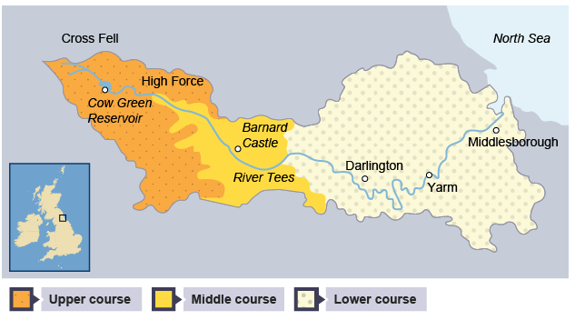
The River Tees is located in NE England. Its source is high in the Pennine Hills. The river flows 128km to its mouth in the North Sea near Middlesbrough.
River Courses
Upper Course
- Characteristics:
- Hard impermeable rocks.
- Vertical erosion has formed a V-shaped valley.
- High Force Waterfall:
- UK's largest waterfall at 21 metres high.
- Located in the upper course.
- Formed by hard rock called Whin Sill (or Whinstone) overlying soft rocks (sandstone and shale).
Middle Course
- Erosion:
- As the River Tees starts to erode sideways (lateral erosion), it forms meanders.
- Meanders can be identified near Barnard Castle.
Lower Course
- Near Yarm, meanders are much larger, and oxbow lakes have formed.
- Levees have formed where the river has flooded.
- Large estuary with mudflats and sandbanks supports wildlife (e.g., Seal Sands protected area).
Human Uses
- Farming:
- Sheep farming in the upper course.
- Tourism:
- The Pennine Way walk and the High Force Waterfall.
- Transport & Settlement:
- The River Tees has been important for transport.
- Towns like Yarm owe their existence to trading stops on the river.