Tropical cyclones (Edexcel GCSE Geography A): Revision Notes
Tropical cyclones
Tropical cyclones are powerful weather systems that develop over warm ocean waters. These massive rotating storms are known by different names depending on where they occur - hurricanes in the Atlantic and Eastern Pacific, typhoons in the Western Pacific, and cyclones in the Indian Ocean and South Pacific regions.
Formation of tropical cyclones
Tropical cyclones develop when specific atmospheric and oceanic conditions come together. The formation process requires several key elements working in sequence.
The most important requirement is warm ocean water with temperatures of or higher. This provides the energy source that powers these massive storm systems. When warm, moist air rises from the ocean surface, it creates the initial conditions needed for cyclone development.
The Formation Process:
The development of tropical cyclones follows a clear sequence:
- Initial Stage: Rising warm air creates thunderstorms that begin to group together, forming a stronger overall airflow system
- Pressure Development: As more warm air continues to rise, an area of very low pressure develops at the centre where all these converging storms meet
- Rotation Formation: The entire system begins to rotate and accelerate, creating the characteristic spinning motion that defines a tropical cyclone
The Coriolis Effect
This rotation occurs due to the Coriolis effect, which is caused by the Earth's rotation. The Coriolis effect deflects moving air masses, creating the curved paths that tropical cyclones follow as they develop and move across ocean basins. This is a fundamental force that shapes the behaviour of all large-scale weather systems.
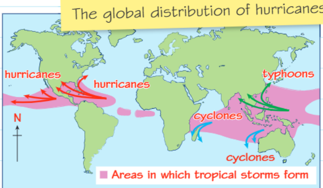
Global distribution and regional names
Tropical cyclones form in specific regions around the world where ocean temperatures remain warm enough to support their development. These areas are concentrated in tropical and subtropical waters, typically between about and latitude in both hemispheres.
Different regions use different names for these storms. In the North Atlantic and Eastern Pacific, they are called hurricanes. The Western Pacific region refers to them as typhoons, while the Indian Ocean and South Pacific regions use the term cyclones. Despite these different names, all of these storms are essentially the same type of weather system with similar characteristics and formation processes.
Why Different Names?
The different regional names for tropical cyclones developed from local languages and historical weather observations. However, meteorologists worldwide use the same scientific classification system to study and track these storms, regardless of their regional names.
Key characteristics
Tropical cyclones have several distinctive features that make them easily identifiable and particularly dangerous weather systems.
The most notable characteristic is their extremely low atmospheric pressure at the centre. This creates a distinctive structure with a cylinder of rising, spiralling air surrounding a central area called the eye. Within the eye, air actually descends, creating an area of high pressure and relatively calm conditions.
The Eye Structure
The eye of a tropical cyclone is typically kilometres in diameter and characterised by:
- Clear skies or broken clouds
- Light winds
- Warm temperatures
- Descending air creating high pressure
Surrounding the eye is the eye wall, which consists of dense cloud banks where the most intense winds and heaviest rainfall occur. This eye wall structure is what gives tropical cyclones their most destructive power.
These storm systems are massive in scale, often reaching kilometres in width and extending up to kilometres high into the atmosphere. This enormous size means they can affect very large geographical areas and maintain their strength over long distances.
Frequency and timing
The timing of tropical cyclone formation follows clear seasonal patterns that differ between the northern and southern hemispheres due to the Earth's orbital cycle and seasonal temperature changes.
In the northern tropics, tropical cyclones are most likely to develop between June and November. This corresponds to the warmest ocean temperatures in these regions. Conversely, in the southern tropics, the cyclone season runs from November to April, when southern hemisphere oceans reach their peak temperatures.
Opposite Seasons
The opposite timing of cyclone seasons in northern and southern hemispheres occurs because when it's summer in one hemisphere, it's winter in the other. This means peak ocean temperatures - essential for cyclone formation - occur at different times of the year in each hemisphere.
Tropical cyclones tend to be more frequent during cooler years, although predicting exact numbers remains challenging for meteorologists. The relationship between global climate patterns and cyclone frequency is complex and influenced by many variables.
Movement patterns
Understanding how tropical cyclones move across ocean basins is crucial for predicting their paths and potential impacts on populated areas.
Cyclone movement is primarily determined by prevailing winds and ocean currents in the surrounding area. These large-scale atmospheric and oceanic circulation patterns essentially steer the storm system along its path.
The distance a cyclone travels over the ocean significantly influences its strength. As the storm moves across warm ocean waters, it continues to collect moisture and energy, often increasing in intensity. This is why storms that travel long distances over warm water can become particularly powerful.
Tropical cyclones typically travel at speeds of around kilometres per hour and can cover distances of up to kilometres in a single day. Modern satellite technology allows meteorologists to track these movements and provide forecasts of likely storm paths, giving coastal communities time to prepare for potential impacts.
Forecasting Improvements
The ability to forecast cyclone movement has dramatically improved emergency preparedness and reduced the loss of life from these powerful weather systems. Advanced satellite tracking and computer modelling now provide accurate predictions days in advance, allowing communities to evacuate and prepare effectively.
The ability to forecast cyclone movement has dramatically improved emergency preparedness and reduced the loss of life from these powerful weather systems, although property damage remains a significant concern in affected areas.
Key Points to Remember:
- Tropical cyclones need warm ocean temperatures of or higher to form and maintain their strength
- They are called different names in different regions: hurricanes, typhoons, or cyclones, but they are all the same type of storm system
- The distinctive eye structure with surrounding eye wall creates the most dangerous conditions in these storms
- Northern and southern hemisphere cyclone seasons occur at opposite times of the year due to seasonal temperature patterns
- Storm movement and intensity are influenced by ocean temperatures and atmospheric conditions along their path