Human Geography of the UK (OCR GCSE Geography B (Geography for Enquiring Minds)): Revision Notes
Human Geography of the UK
Introduction
The UK in the 21st century faces several geographical challenges related to how its population is distributed and how its land is used. Understanding patterns of population density, land use, and housing development helps explain the pressures facing modern Britain.
Population and distribution in the UK
The UK has a population of approximately 65 million people living on a relatively small island. This creates a high population density, meaning there are many people concentrated within a limited land area.
However, the population is not spread evenly across the country. The vast majority of people reside in urban areas such as cities and towns. When viewed from above at night, the pattern becomes clear – bright clusters of light mark where population is concentrated, while large areas remain dark and sparsely populated.
Despite this concentration of people, urban areas cover only 12% of the UK's total land area. This might seem surprising given how crowded cities feel. Even within urban areas, half of the land consists of green space, including parks, gardens, and open areas.
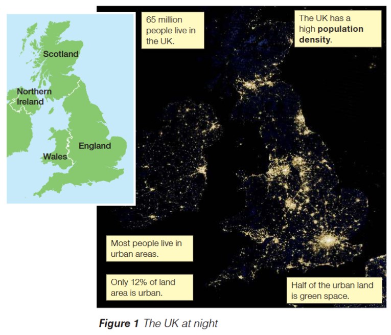
The satellite imagery reveals an interesting paradox: most people live in urban areas, yet these cities and towns occupy a relatively small proportion of the country. This creates a situation where the UK can feel crowded whilst still having substantial amounts of undeveloped land.
Land use patterns in the UK
The way land is used across the UK reveals the country's priorities and geographical characteristics. The breakdown shows distinct patterns:
| Land use type | Percentage (%) |
|---|---|
| Urban (cities and towns) | 12 |
| Arable land (farmland growing crops) | 20 |
| Grassland (grazing land for animals) | 44 |
| Woodland | 13 |
| Mountain and moorland | 7 |
| Water (lakes and rivers) | 1 |
| Other land uses (e.g. roads and transport) | 3 |
Grassland dominates UK land use at 44%, reflecting the country's strong agricultural tradition, particularly for livestock farming. Sheep and cattle grazing occurs extensively across rural areas.
Arable land, where crops are grown, accounts for 20% of the total land area. This agricultural land produces food for the population and contributes to the rural economy.
Woodland covers 13% of the UK, providing habitats for wildlife, recreational spaces, and contributing to carbon storage. Mountain and moorland areas occupy 7%, typically found in upland regions like Scotland, Wales, and northern England.
The relatively small urban footprint of 12% demonstrates that whilst most people live in cities, these settlements are geographically compact. This concentration allows the UK to maintain large areas of agricultural and natural land despite having a substantial population.
Water bodies such as lakes and rivers represent just 1% of land area, whilst roads, railways, and other transport infrastructure account for 3%.
The housing shortage challenge
Despite the UK having substantial undeveloped land, there exists a significant housing shortage, particularly in south-east England. This creates a paradox – there is space available for new homes, yet not enough houses are being built to meet demand.
Three Main Factors Causing the Housing Shortage:
Planning permission requirements - New housing developments require planning permission from local authorities. The planning process can be lengthy and complex. Local communities often oppose new housing developments in their areas, creating delays or preventing construction altogether. This is sometimes called "NIMBYism" (Not In My Back Yard), where residents support housing in principle but object to it being built near them.
Green belt protection - Land surrounding many cities is designated as green belt. These protected areas have strict planning controls that prevent urban sprawl and preserve countryside close to cities. Whilst green belts serve important environmental and recreational purposes, they limit where new housing can be built, restricting the supply of available development land near where people want to live.
Land price speculation - Property prices in the UK have risen consistently over recent decades. Landowners often choose not to sell their land, hoping that values will increase further in the future. This speculation reduces the amount of land available for housing development at any given time, contributing to the shortage and maintaining high property prices.
These factors combine to create a situation where demand for housing significantly exceeds supply, driving up costs and making homeownership increasingly difficult, especially for younger people.
Exam guidance
Tips for Answering Questions on UK Human Geography:
- Describe questions: Use specific statistics such as "12% urban land" or "65 million population" to support your description
- Explain questions: Link causes and effects – for example, connect planning restrictions to housing shortages
- Evaluate questions: Consider both sides – the UK appears crowded in cities but has substantial rural space; green belts protect countryside but restrict housing development
Remember to use precise geographical terminology like "population density", "urban areas", and "land use" rather than vague terms like "busy" or "full".
Remember!
Key Points to Remember:
- The UK has approximately 65 million people, creating high population density despite the relatively small land area
- Most people live in urban areas, which cover only 12% of the total land area, with grassland (44%) being the dominant land use
- A housing shortage exists despite available land because of three main factors: planning permission requirements and local opposition, green belt protection around cities, and land price speculation by owners
- Half of urban land consists of green space, meaning cities contain significant parks and gardens
- The uneven distribution of population creates crowded cities whilst large rural areas remain sparsely populated