Earthworks (Leaving Cert DCG): Revision Notes
Earthworks
Earthworks are a fundamental aspect of road and infrastructure construction that involve moving soil and rock materials to create the desired ground profile. When building roads, car parks, or other structures, engineers must carefully calculate how much material needs to be removed (cut) or added (fill) to achieve the correct formation level.
Understanding cut and fill operations
The formation level refers to the target height or level where the proposed road or car park will be built. This is the finished surface level that vehicles will travel on.
Cut operations involve removing excess material from areas where the natural ground level is higher than the required formation level. This material must be excavated and either moved to fill areas or removed from the site entirely.
Fill operations involve adding material to areas where the natural ground is lower than the formation level. This creates embankments or raised sections that bring the ground up to the correct height.
When constructing roads through varied terrain, sections will typically require both cutting and filling. The goal is to balance the amount of cut material with the fill requirements, minimising the need to import or export soil.
Slope gradients and stability
Different slope ratios are used for cut and fill operations to ensure stability and safety:
Cutting slopes typically use a ratio of 1:1 (45-degree angle). This steeper slope is possible because the material being cut is usually stable existing ground that can support this gradient without significant risk of collapse.
Embankment or fill slopes use a gentler ratio of 1:1.5. This means for every 1 unit of vertical height, the slope extends 1.5 units horizontally.
The gentler gradient for fill slopes is necessary because fill material needs more support to remain stable and prevent sliding or settlement. Using the wrong slope ratio can lead to dangerous collapses or structural failures.
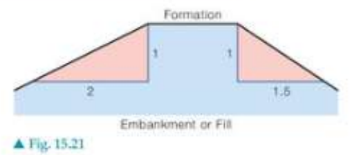
The diagram above shows a typical road embankment cross-section. The formation area (shown in light blue) sits on top of the embankment or fill material. The sloped sides demonstrate the different gradient ratios used for stability.
Formation levels and contour analysis
Engineers use contour maps to analyse the existing ground levels and plan earthwork operations. Contour lines represent points of equal elevation, allowing designers to visualise how the proposed road will interact with the natural terrain.
Ground contours at specific vertical intervals help determine where cut and fill operations will be needed. By comparing the proposed formation level with existing ground levels shown on contour maps, engineers can calculate the volume of earthwork required.
Practical calculations in earthworks
When planning earthworks, several key measurements must be determined:
- Formation width: The width of the finished road surface
- Formation level: The target elevation for the road surface
- Side slope ratios: Different ratios for cuts (typically 1:1) and fills (typically 1:1.5)
- Cut and fill volumes: The amount of material to be moved
Worked Example: Road Planning
If a road has a formation width of 16 metres and a formation level of 75 metres above sea level, engineers must:
- Compare this target level with existing ground elevations from contour maps
- Identify areas where natural ground is above 75m (requiring cut operations)
- Identify areas where natural ground is below 75m (requiring fill operations)
- Calculate the volumes of material to be moved
Key considerations for earthwork design
The topography of the land significantly influences earthwork requirements. In hilly terrain, roads may need substantial cutting through elevated areas and filling across valleys or depressions.
Soil Stability Factors Soil stability and drainage must also be considered. Different soil types have varying load-bearing capacities and drainage characteristics that affect slope design and fill material selection.
Environmental factors such as erosion control and vegetation protection may influence slope gradients and construction methods.
Key Points to Remember:
- Cut removes excess material where ground is too high; fill adds material where ground is too low
- Formation level is the target height for the finished road surface
- Cutting slopes use steeper gradients (1:1) while fill slopes use gentler gradients (1:1.5) for stability
- Contour maps help visualise existing ground levels and plan earthwork operations
- Balancing cut and fill volumes minimises material transport costs and environmental impact