Rural Settlement Patterns (Leaving Cert Geography): Revision Notes
Rural Settlement Patterns
Rural settlement patterns describe how individual houses and buildings are arranged across countryside areas. Understanding these patterns helps explain how people have chosen to live and work in rural environments throughout history.
Settlement patterns reflect the relationship between human communities and their physical environment, showing how geographical features, economic factors, and historical developments have influenced where and how people choose to live.
Types of rural settlement patterns
There are four main types of rural settlement patterns found in the countryside:
- Nucleated settlement (also called clustered settlement)
- Linear settlement (also called ribboned settlement)
- Dispersed settlement
- Absence of settlement
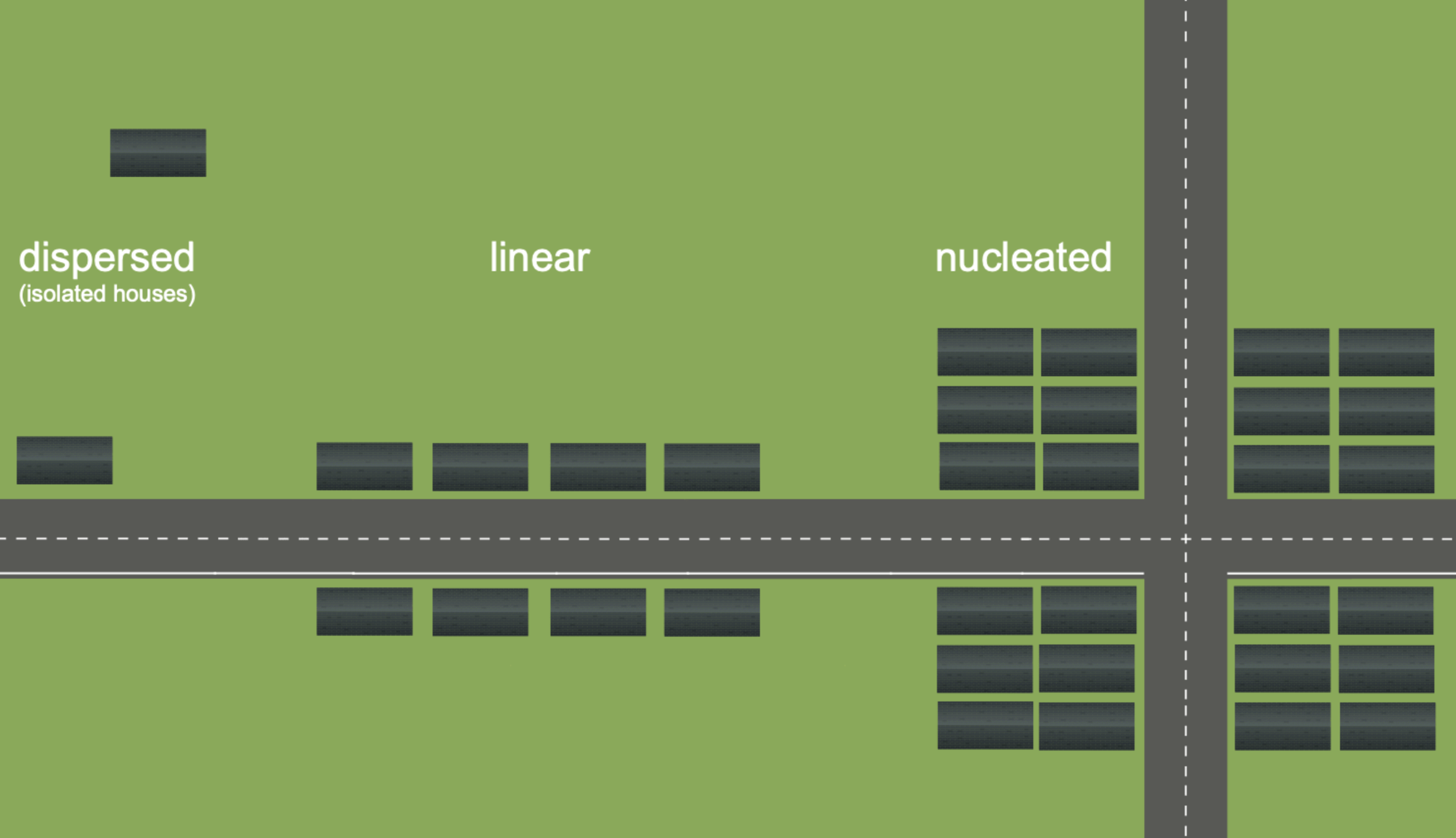
Nucleated settlement
Nucleated settlement refers to houses that are grouped together in clusters, often found in housing estates, at focal points where roads meet, or in villages.
Nucleated settlements develop when houses are built close together in concentrated groups. These settlements commonly form at important meeting points such as:
- Road junctions and crossroads
- River crossing points and bridges
- Areas around housing estates
The clustering effect occurs because businesses like shops and pubs, along with services such as schools and churches, tend to locate at these meeting points. This creates the central core or 'nucleus' of villages and small towns.
Historical development of nucleated settlements
Many older nucleated settlements developed around:
- Former landlord estates - where workers lived close to the main estate
- Castles and monasteries - which provided protection and charity to local people
- Ancient farming systems - particularly in western Ireland, some small nucleated settlements are remnants of the Rundale system, where farming families lived together in small clusters
Example: Village Formation
A typical nucleated settlement might develop at a river crossing where:
- A bridge creates a natural focal point
- A pub and shop establish themselves to serve travellers
- A church and school locate nearby to serve the community
- Houses cluster around these central services
- The settlement grows into a village with a clear centre
Linear settlement
Linear settlement consists of houses built in a line along roads, primarily for easy access to communications and transport links.
Linear settlement became particularly popular in Ireland during the period from the 1960s to 1990s. Several factors combined to encourage this development pattern:
Infrastructure development
During this era, many roads gained access to essential services:
- Electricity and telephone lines were extended along road networks
- Water and sewage mains were installed alongside roads
- Houses with road frontage became highly desirable
Practical advantages
People chose to build along roads because it provided:
- Convenient access to towns and villages with more services
- Easy connection to utilities and communications
- Better transport links for work and daily activities
Coastal linear settlement
Linear patterns also develop along coastlines, particularly in scenic areas where people build houses along seafronts to enjoy attractive views of the sea.
The preference for linear settlement during this period reflected Ireland's modernisation, as improved infrastructure made road-frontage properties particularly attractive for new development.
Dispersed settlement
Dispersed settlement describes isolated, 'one-off' dwellings that are scattered across wide countryside areas, typically farmhouses surrounded by their own farmland.
Historical origins
Dispersed settlement patterns have important historical roots connected to changes in farming:
Before the eighteenth century, Ireland had an open-field system called 'common land'. In this system:
- All animals grazed together on shared land
- A central settlement housed the farming community
- Land was worked collectively
The Agricultural Revolution's impact
During the eighteenth century Agricultural Revolution, significant changes occurred:
- Land ownership patterns changed - common land was divided up
- Individual farmers received their own separate plots
- Farmers built individual houses on their own land rather than living in central settlements
Example: From Common to Individual Land
Under the old system:
- 10 farming families lived together in a village
- They shared 500 acres of common grazing land
- Everyone worked the land collectively
After the Agricultural Revolution:
- Each family received their own 50-acre plot
- Families built houses on their individual land
- The original village was abandoned
- Houses became scattered across the countryside
Modern characteristics
Today, dispersed settlements are characterised by:
- Houses that can be widely spaced apart
- Particularly common in eastern and southern areas where farms are large
- Location near local and third-class roads or at the end of long driveways
Absence of settlement
In some areas, there is no settlement at all. This absence typically indicates that the area is unsuitable for human habitation.
Physical factors causing absence of settlement
Areas without settlement often have challenging physical characteristics:
Waterlogged areas:
- Bogs and marshes
- Flat, low-lying floodplains prone to regular flooding
Difficult terrain:
- Highland and mountainous areas
- Steep slopes that make building houses and roads both difficult and expensive
Human factors
Settlement absence can also result from:
- Outward migration - particularly evident along Ireland's west coast
- Economic factors that make areas unviable for development
Absence of settlement means no evidence of settlement exists, usually because the area is unsuitable for development due to physical constraints like mountainous terrain, bogs, marshes, or flood-prone locations.
Key settlement terminology
Understanding rural settlement patterns requires familiarity with several important terms:
- Rundale system - An ancient land division system where plots were rented and farmed by multiple tenants
- Road frontage - Property that faces directly onto a road, considered desirable for access
- Focal point - A central meeting place where roads converge or important features exist
These terms frequently appear in geography examinations and are essential for understanding how settlement patterns developed and continue to evolve.
Key Points to Remember:
- Four main types of rural settlement exist: nucleated, linear, dispersed, and absence of settlement
- Nucleated settlements form clusters around important meeting points like road junctions and river crossings
- Linear settlements developed along roads, especially between the 1960s-1990s when infrastructure improved
- Dispersed settlements resulted from the Agricultural Revolution when common land was divided into individual farms
- Settlement absence occurs in areas that are physically unsuitable, such as bogs, steep slopes, or flood-prone regions