Folding (Grade 10 NSC Matric Geography): Revision Notes
Folding
Folding is one of the most spectacular geological processes that shapes our Earth's surface. When you see dramatic mountain ranges like the Himalayas, the Alps, or even the Western Cape mountains in South Africa, you're witnessing the incredible results of folding that has taken place over millions of years.
What is folding?
Folding occurs when layers of rock are squeezed and bent by enormous forces within the Earth.
Think of pushing a pile of blankets against a wall - the layers will buckle and fold into wave-like shapes. This is exactly what happens to rock layers beneath the Earth's surface when they experience intense pressure.
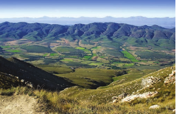
Fold mountains are mountain ranges formed when thick layers of sedimentary rock are compressed and folded during plate movement. These mountains create interconnected ranges that can cover vast areas, like the fold mountains visible in this Western Cape landscape.
A mountain range consists of interconnected mountains of the same type that cover a large area, whilst a mountain peak is the highest point of a mountain that stands out above the surrounding land.
Formation of fold mountains
Fold mountains develop at convergent plate boundaries where tectonic plates collide with tremendous force.
This process unfolds over millions of years through distinct stages - geological processes operate on time scales that are difficult for humans to comprehend!
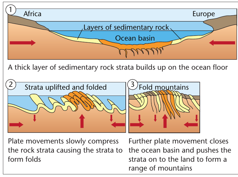
Stage 1: Sediment accumulation
- Thick layers of sedimentary rock build up on ocean floors over vast periods
- These sedimentary deposits can reach thousands of metres in thickness
- The layers remain relatively horizontal during this accumulation phase
Stage 2: Plate convergence and compression
- Tectonic plates begin moving towards each other
- The ocean basin gradually narrows as plates converge
- Enormous compressional forces start building up in the rock layers
Stage 3: Folding and uplift
- The thick sedimentary layers are squeezed and compressed by plate collision
- Rock strata buckle and fold upwards, creating complex wave-like patterns
- The ocean basin closes completely, and fold mountains emerge from the process
Real-World Example: The Alps Formation
The Alps formed when the African plate moved northward and collided with the European plate, compressing and folding the sedimentary rocks that had accumulated in the ancient ocean between them. This process created the dramatic Alpine landscape we see today.
Global distribution of fold mountains
Fold mountains follow specific patterns around the world, closely related to the boundaries between tectonic plates.
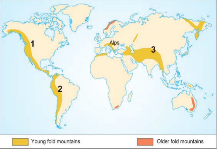
Notice how fold mountains occur in distinct belts around the world - this isn't random! They mark the locations where tectonic plates have collided throughout Earth's history.
The world's fold mountains can be classified into two main categories:
Young fold mountains (relatively recently formed):
- The Rocky Mountains in North America
- The Andes along South America's western coast
- The Himalayas across Asia
- The Alps in Europe
Older fold mountains (formed much earlier in geological time):
- Scattered across various continents
- Significantly lower in elevation due to millions of years of erosion
- More rounded and weathered in appearance
Key insight: Young fold mountains remain tall and jagged because they haven't experienced extensive erosion yet. Older fold mountains have been worn down by weathering and erosion over much longer periods, making them considerably lower and more rounded.
Landforms associated with folding
When rock layers fold under pressure, they create distinctive landforms with specific characteristics and names.
Anticlines and synclines
The fundamental building blocks of folded landscapes are anticlines and synclines:
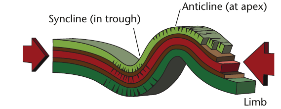
Identifying Anticlines and Synclines
Anticline: The upward-folding section that creates an arch-like shape - think of it as the "peak" of a wave
Syncline: The downward-folding section that forms a trough or valley shape - like the "dip" between waves
Limb: The sloping sides that connect anticlines and synclines
Memory tip: Anticlines are Arches, Synclines are Sinks!
These alternating patterns create the characteristic wave-like appearance of folded mountain landscapes.
How erosion affects folds
Surprisingly, anticlines and synclines behave very differently when exposed to weathering and erosion over time:
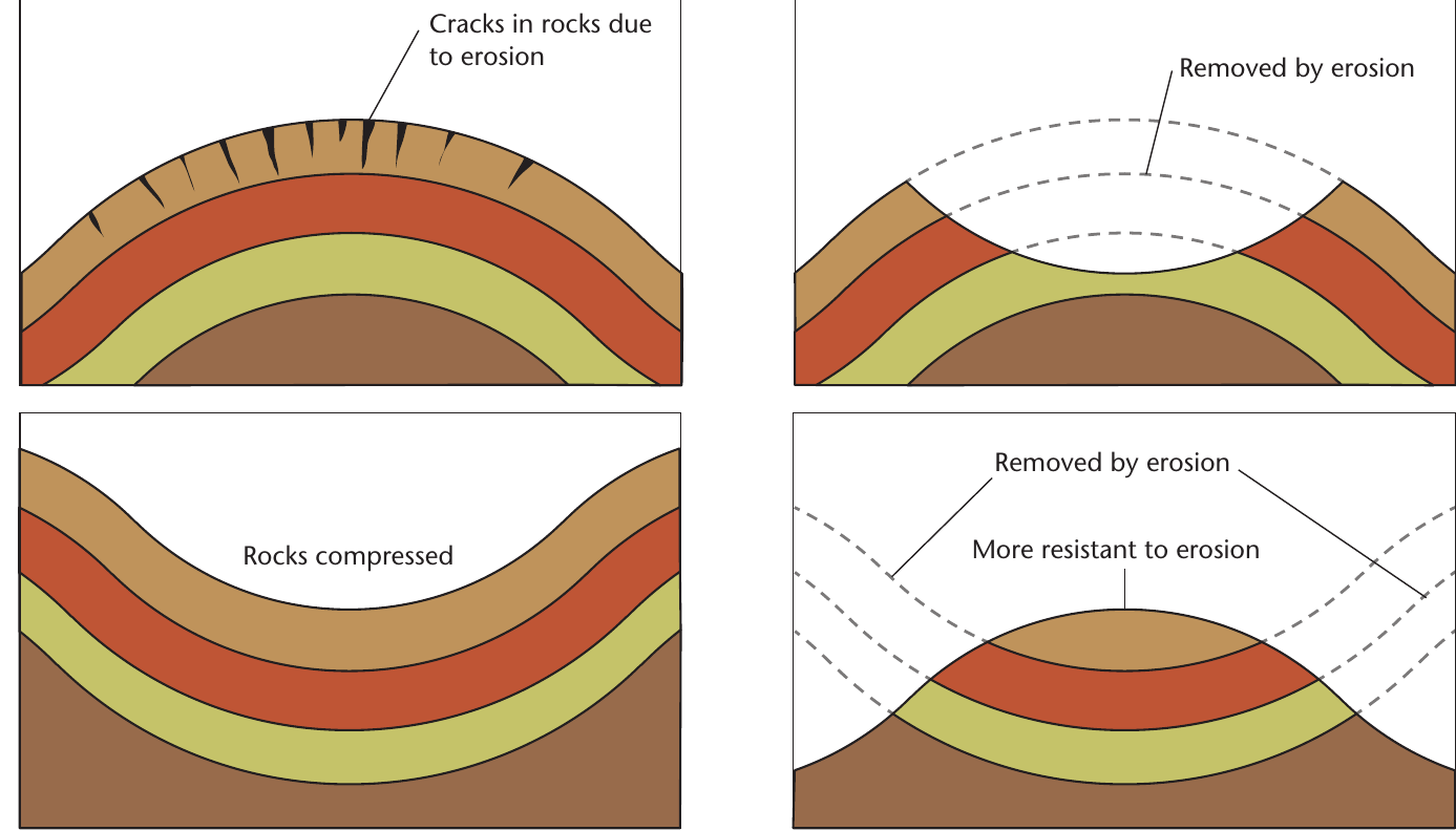
Counterintuitive but True!
Over long periods, anticlines often become valleys whilst synclines often become hills. This seems backwards, but there's a logical geological reason for this reversal.
Why anticlines erode more easily:
- The folding process stretches and creates cracks in the rock at the peak
- Water can penetrate these cracks more readily
- The curved arch shape exposes more surface area to weathering agents
- Over time, anticlines often become valleys
Why synclines resist erosion better:
- Rock layers have been compressed tightly together during folding
- Fewer cracks exist for water and weathering agents to exploit
- The compressed structure makes them more resistant to breakdown
- Synclines often end up forming the higher ground after long periods of erosion
This explains the fascinating phenomenon where today's valleys might mark the locations of ancient anticlines, whilst hills often indicate where synclines originally formed.
Different types of folds
The amount and direction of pressure applied to rock layers creates various types of folds, each with distinctive characteristics:
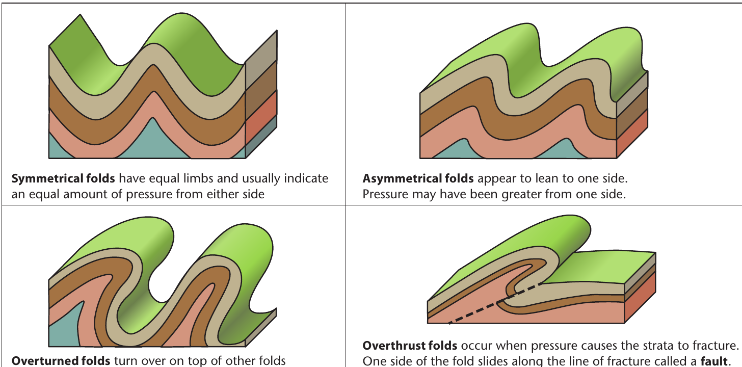
Symmetrical folds:
- Both limbs slope at equal angles
- Indicate balanced pressure from both directions
- Create regular, wave-like patterns in the landscape
Asymmetrical folds:
- One limb slopes more steeply than the other
- Show that greater pressure came from one particular direction
- Common in areas where plates collide at oblique angles
Overturned folds:
- Extreme pressure causes one limb to fold completely over the other
- Create very complex geological structures
- Demonstrate intense compressional forces
Overthrust folds:
- Pressure becomes so intense that rocks actually fracture
- One section slides over another along a fault line
- Create some of the most dramatic and complex mountain landscapes
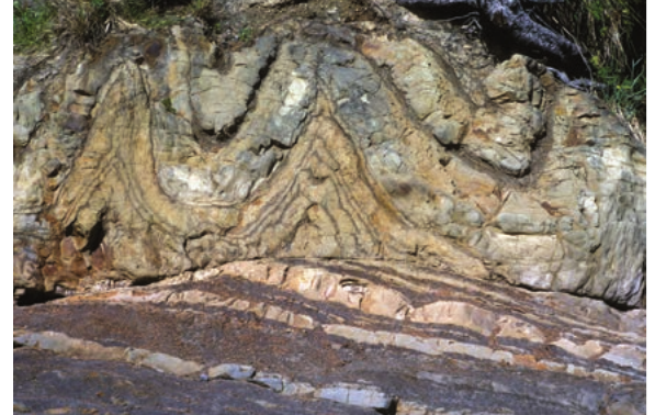
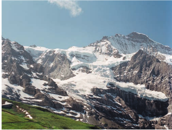
This photograph shows real folded rock formations where you can observe the dramatic zigzag patterns created by intense geological folding processes.
Key Points to Remember:
- Fold mountains form at convergent plate boundaries through compression of sedimentary layers over millions of years
- Anticlines are upward arch-shaped folds, whilst synclines are downward trough-shaped folds
- Young fold mountains are tall and jagged, but older fold mountains have been worn down by erosion
- Synclines often become hills because they resist erosion better than anticlines, which frequently become valleys
- The type and shape of fold depends on the amount, direction, and duration of pressure applied to the rock layers
Key vocabulary for examinations
Essential Terms:
- Compressional forces: Forces of compression or squeezing that push rock layers together
- Convergent plate boundary: Location where two tectonic plates move towards each other
- Sedimentary rock strata: Horizontal layers of sedimentary rock built up over geological time
- Fault: A crack or fracture in rock where movement has occurred
- Limb: The sloping side of a fold structure
- Symmetrical fold: A balanced fold with both limbs at the same angle
- Asymmetrical fold: An unbalanced fold where one limb is steeper than the other
- Overturned fold: A fold where one limb has been pushed completely over the other
- Overthrust fold: A fold that has fractured, with one section sliding over another