Vertical Exaggeration (Grade 11 NSC Matric Geography): Revision Notes
Vertical Exaggeration
What is vertical exaggeration?
Vertical exaggeration is a technique used in geography to make terrain features more visible and easier to study. When we create cross-sections of landscapes, the natural scale often makes hills and valleys appear very flat and difficult to see clearly.
Vertical exaggeration (VE) refers to how much we stretch or increase the vertical scale compared to the horizontal scale in a cross-section. This helps us see physical features like hills, valleys, and slopes much more clearly than they would appear if we used the same scale for both horizontal and vertical measurements.
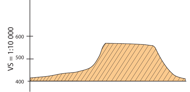
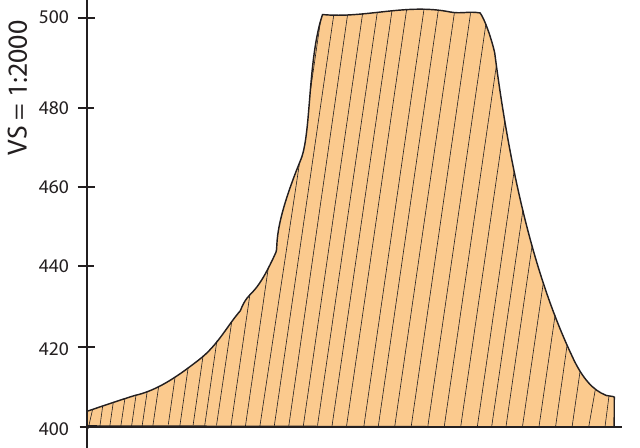
Think of it like this: imagine looking at a photograph of a mountain range from far away - the mountains might look quite flat. But if you could stretch the image vertically, making it taller, the mountains would become much more dramatic and easier to see. This is exactly what vertical exaggeration does for geographical cross-sections.
Why do we use vertical exaggeration?
Without vertical exaggeration, many landscape features would be barely visible on maps and cross-sections. Here's why geographers use this technique:
- Better visibility: Makes small changes in elevation much more obvious
- Easier analysis: Helps students and researchers study terrain features more effectively
- Clearer communication: Makes it easier to show and explain geographical features to others
- Enhanced detail: Reveals subtle landscape patterns that would otherwise be missed
The images below show the same terrain feature drawn with two different vertical scales, demonstrating how vertical exaggeration affects our view of the landscape.
How to calculate vertical exaggeration
The formula for calculating vertical exaggeration is straightforward:
Where:
- VE = Vertical exaggeration
- VS = Vertical scale
- HS = Horizontal scale
Important calculation steps
When calculating vertical exaggeration, you must ensure both scales use the same units. Here's the process:
Worked Example: Converting Units and Calculating VE
Step 1: Convert measurements to the same units
- If the vertical interval is given as 1 cm:20 m, multiply by 100 to convert metres to centimetres
- 1 cm:20 m × 100 = 1 cm:2,000 cm
Step 2: Express as a ratio
- This becomes 1:2,000 for the vertical scale
Step 3: Apply the formula
- Divide the vertical scale by the horizontal scale
- Remember: when dividing ratios, you divide the second number of the first ratio by the second number of the second ratio
Always ensure both scales use the same units before calculating. Unit conversion is crucial - multiply by 100 to convert metres to centimetres.
Working out vertical scales for different map types
Different types of maps use different standard scales, and understanding these is crucial for accurate calculations.
Topographic maps
Topographic maps have standardized scales that are important to remember:
- Horizontal scale: Always 1:50,000
- Vertical interval: Usually 1 cm:20 m or 1 cm:100 m
Worked Example: Topographic Map VE Calculation
Given:
- Vertical interval: 1 cm:20 m
- Horizontal scale: 1:50,000
Step 1: Convert vertical scale to same units
- VS = 1 cm:20 m × 100 = 1:2,000
Step 2: Apply the formula
- times
Orthophoto maps
Orthophoto maps use different standard scales:
- Horizontal scale: Always 1:10,000
- Vertical interval: Usually 1 cm:20 m or 1 cm:40 m
Worked Example: Orthophoto Map VE Calculation
Given:
- Vertical interval: 1 cm:40 m
- Horizontal scale: 1:10,000
Step 1: Convert vertical scale to same units
- VS = 1 cm:40 m × 100 = 1:4,000
Step 2: Apply the formula
- times
Practical applications and examples
Understanding vertical exaggeration is essential for accurate geographical analysis. Key applications include:
- Reading topographic maps accurately: Knowing how much the vertical features have been exaggerated
- Creating cross-sections: Choosing appropriate scales for your own geographical drawings
- Comparing different maps: Understanding why the same area might look different on various map types
- Fieldwork planning: Getting a realistic sense of terrain difficulty and elevation changes
Exam tips
When working with vertical exaggeration questions, success depends on following a systematic approach:
- Always check that your units match before calculating
- Remember the standard horizontal scales (1:50,000 for topographic, 1:10,000 for orthophoto)
- Show your working clearly - marks are often awarded for method even if the final answer is incorrect
- Practice converting between different units (metres to centimetres, etc.)
- Understand that higher vertical exaggeration makes terrain appear more dramatic
Common Mistake to Avoid: Never forget to convert units before calculating! Many students lose marks by trying to divide measurements that are in different units (e.g., metres and centimetres).
Remember!
Key Points to Remember:
- Vertical exaggeration makes terrain features more visible by stretching the vertical scale compared to the horizontal scale
- The formula is - always ensure units match before calculating
- Topographic maps use 1:50,000 horizontal scale while orthophoto maps use 1:10,000
- Unit conversion is crucial - multiply by 100 to convert metres to centimetres
- Without vertical exaggeration, many landscape features would be too flat to see clearly on cross-sections and maps