Overview of South Africa's Topography (Grade 11 NSC Matric Geography): Revision Notes
Overview of South Africa's Topography
Understanding topography
Topography refers to the natural shape and features of the land surface. It shows us where physical features like mountains and valleys are located, and helps us understand which areas are high-lying and which are low-lying. When we study South Africa's topography, we can see that the country has a very distinctive and unusual landscape pattern.
South Africa's landscape is quite remarkable because most of the country sits at a very high elevation above sea level. The country shows dramatic variations in height, from coastal areas that are less than 200 meters above sea level to mountainous regions that reach over 3000 meters high.
South Africa's unique topographical structure makes it stand out from many other countries around the world. This elevated landscape has profound effects on everything from climate patterns to human settlement distribution.
The central plateau
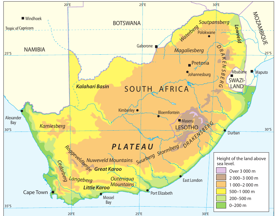
Most of South Africa's interior is covered by a large, raised, and relatively flat area of land called a plateau. This central plateau forms the backbone of South Africa's topography and covers a significant portion of the country's landmass.
The plateau has an average height of approximately 1500 meters above sea level, making it quite elevated compared to many other countries. However, the plateau is not uniform in height across the country. The western side of the plateau sits at just under 1000 meters above sea level, while the eastern side reaches closer to 1800 meters above sea level.
The "Bowl-Like" Shape
This elevated interior plateau is what gives South Africa its characteristic "bowl-like" shape when viewed in cross-section, with the high interior dropping down to lower coastal areas. This unique structure influences many aspects of South African geography.
The escarpment system
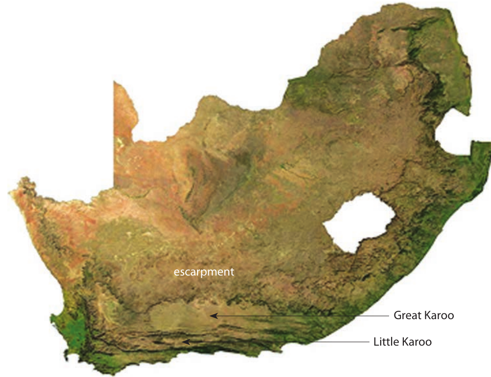
One of South Africa's most distinctive topographical features is the escarpment. An escarpment is essentially a steep slope that connects low-lying coastal areas with the high-lying interior plateau. Think of it as nature's giant staircase leading up from the coast to the elevated interior.
The South African escarpment is particularly impressive because it's made up of several mountain ranges that join together to form this continuous steep slope. When you examine the topographical map, you can identify six major mountain ranges that make up this escarpment system.
Major Mountain Ranges of the Escarpment
The escarpment system consists of several interconnected mountain ranges that create South Africa's dramatic landscape transition. Understanding these ranges is essential for grasping the country's topographical structure.
Some important mountain ranges that form part of the escarpment include the Kamiesberg in the west, the Roggeveldberge, the Nuweveld Mountains, the Stormberg, and the famous Drakensberg in the east. These ranges work together to create the dramatic transition between South Africa's coastal lowlands and its elevated interior.
The Kalahari Basin
In the northwestern part of the country, the plateau gradually slopes downward into an area known as the Kalahari Basin. This region represents where South Africa's elevated interior begins to dip down toward lower elevations as it extends toward neighboring Botswana and Namibia.
The Kalahari Basin shows how South Africa's topography connects with the broader southern African landscape, demonstrating that the country's elevated plateau doesn't just end abruptly but transitions gradually into different geological regions.
Cape Fold Mountains
The southern part of South Africa features a distinctive mountain system known as the Cape Fold Mountains. These mountains are different from the escarpment mountains because they run in chains that are roughly parallel to the southern coast.
The Cape Fold Mountains include several notable ranges such as the Cedarberg, Langeberg, and Outeniqua Mountains. What makes these mountains particularly interesting is that some parts run in a north-south direction, almost parallel to the west coast of the Western Cape, while other sections run east-west parallel to the southern coast.
Directional Patterns of Cape Fold Mountains
The unique directional patterns of these mountain ranges - some running north-south and others east-west - create a complex geographical framework that influences drainage patterns and regional climate variations in the Western and Eastern Cape provinces.
The Karoo regions
Between the various mountain systems, South Africa has two important semi-arid regions known as the Great Karoo and Little Karoo.
The Great Karoo is the larger of these two regions and sits between the escarpment (the steep slopes leading up to the central plateau) and the northern chain of the Cape Fold Mountains. This creates a substantial semi-arid basin in the interior of the country.
The Little Karoo is smaller and lies between the northern and southern chains of the Cape Fold Mountains. This creates a valley-like region between parallel mountain ranges in the southern part of the country.
Agricultural Importance of the Karoo Regions
Both Karoo regions are characterized by their relatively flat terrain and semi-arid climate conditions, making them important agricultural and pastoral areas despite their challenging environmental conditions. These regions play a crucial role in South Africa's sheep farming and agriculture.
Elevation patterns and characteristics
South Africa's topographical map reveals several important patterns. The color-coding system used in topographical maps shows elevation changes clearly - green areas represent the lowest elevations (0-200 meters above sea level), while brown and orange areas show the higher elevations (over 1500 meters above sea level).
The coastal areas, shown in green, demonstrate how narrow the low-lying coastal plain is in most parts of the country. This narrow coastal strip quickly gives way to the dramatic rise of the escarpment, leading up to the elevated interior plateau shown in brown and orange colors.
Topographical Influences on South African Geography
The topographical patterns explain many aspects of South Africa's climate, drainage patterns, and human settlement patterns. The elevated interior creates different climatic conditions compared to the coastal areas, while the escarpment influences rainfall patterns and river flow directions.
Key Points to Remember:
- Topography refers to the relief and physical features of the land surface, showing where mountains, valleys, and different elevations are located
- South Africa's plateau covers most of the interior at an average height of 1500 meters above sea level, with the western side lower (~1000m) and eastern side higher (~1800m)
- The escarpment is a steep slope system made up of multiple mountain ranges that connects the low coastal areas to the high interior plateau
- The Great Karoo lies between the escarpment and northern Cape Fold Mountains, while the Little Karoo sits between the northern and southern Cape Fold Mountain chains
- South Africa's distinctive topography creates a "bowl-like" cross-section with elevated interior and lower coastal areas, influencing climate, drainage, and settlement patterns across the country