Drainage Basins (Grade 12 NSC Matric Geography): Revision Notes
Drainage Basins
Understanding flow characteristics
The type of landscape that a river flows over plays a crucial role in determining how water moves through the river system. There are two main types of water flow that you need to understand: laminar flow and turbulent flow.
Laminar flow occurs when water moves smoothly through a channel with even surfaces. This type of flow is highly efficient because less energy is wasted overcoming friction. You'll typically find laminar flow in the lower sections of rivers where the channel is smoother and more regular.
Turbulent flow happens when water moves through rough, uneven channels with rocky beds and irregular surfaces. This creates swirling patterns and eddies in the water, which increases the surface area exposed to friction. Turbulent flow is much less efficient and commonly occurs in the upper sections of rivers where the terrain is more mountainous and rocky.
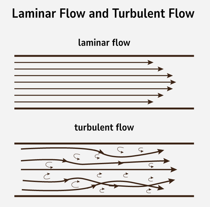
The key difference between these flow types is efficiency - smooth channels allow water to flow more easily, whilst rough channels create resistance and turbulence.
What is a drainage basin?
A drainage basin is the entire area of land that is drained by a river system and all its tributaries. Think of it as a giant funnel that collects all the water from precipitation and channels it towards a single outlet point. Understanding the different components of a drainage basin is essential for analysing how rivers work.
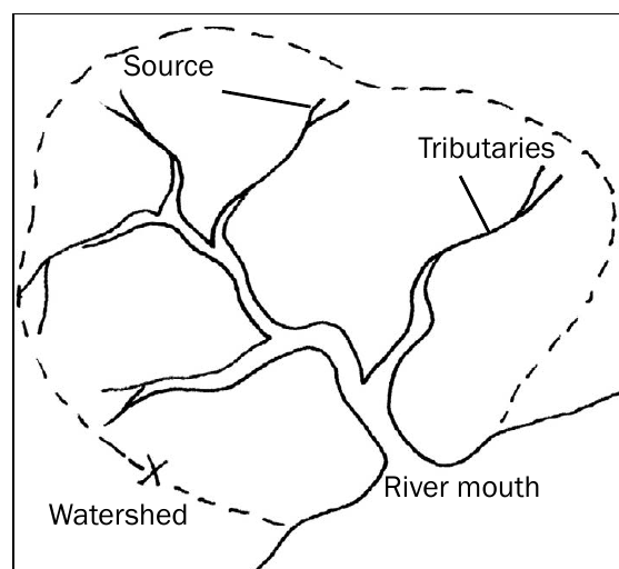
Key components of a drainage basin
Every drainage basin contains several important features that work together as a system:
- Source: This is where the river begins, often in mountainous areas or highland regions where water collects from springs, melting snow, or surface runoff
- Tributaries: These are smaller streams and rivers that flow into the main river, contributing additional water to the system
- River mouth: The point where the river ends, usually flowing into the sea, a lake, or joining a larger river
- Watershed: This is the boundary line that separates one drainage basin from another - imagine it as the ridge line that determines which direction water will flow
Rivers don't exist in isolation. Each river is part of a larger river system that includes the main channel plus all the tributaries that feed into it.
Understanding drainage density
Drainage density is a measure that describes how many streams and tributaries exist within a particular drainage basin. This concept helps geographers understand the characteristics of different river systems and the factors that influence their development.
Factors affecting drainage density
The number of streams in a drainage basin depends on the balance between two key processes: infiltration and surface runoff.
Areas with high infiltration rates tend to have fewer surface streams because more water soaks into the ground rather than flowing over the surface. This results in low drainage density. Several factors promote high infiltration:
- Gentle slopes that allow water time to soak in
- Dense vegetation cover that slows down water flow
- Soft, light rainfall that doesn't overwhelm the ground's capacity to absorb water
- Permeable soil types that allow water to penetrate easily
Areas with high surface runoff develop more streams and tributaries, creating high drainage density. Factors that increase runoff include:
- Steep slopes that cause water flow quickly over the surface
- Heavy, intense rainfall that exceeds the ground's infiltration capacity
- Sparse vegetation that provides little resistance to water flow
- Impermeable rock or soil that prevents water from soaking in
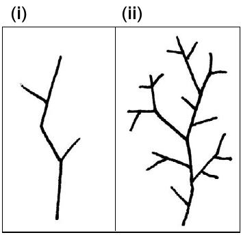
Interpreting drainage patterns
When examining drainage basin diagrams, you can identify the density by counting the number of tributaries and branches. A sparsely branched system indicates low drainage density, whilst a highly branched, tree-like pattern suggests high drainage density.
Practical applications
Understanding drainage basins is crucial for several practical applications. The characteristics of drainage basins directly influence how water behaves in the landscape, making this knowledge essential for various fields of study and practical planning.
Key Applications:
- Flood management: Areas with high drainage density may experience faster flood responses because surface runoff reaches rivers quickly
- Water resource planning: The size and characteristics of drainage basins determine water availability
- Environmental management: Drainage basin boundaries help define catchment areas for conservation efforts
When answering exam questions about drainage basins, remember to:
- Identify all the key components (source, tributaries, mouth, watershed)
- Explain the relationship between infiltration, runoff, and drainage density
- Use specific examples to support your explanations
- Consider how human activities might affect drainage basin characteristics
Key Points to Remember:
- A drainage basin includes all the land area drained by a river system and its tributaries
- Laminar flow (smooth channels) is more efficient than turbulent flow (rough channels)
- Drainage density depends on the balance between infiltration and surface runoff
- High infiltration leads to fewer streams (low density), whilst high runoff creates more streams (high density)
- Key drainage basin components are: source, tributaries, river mouth, and watershed boundary