Coastal Systems (AQA A-Level Geography): Revision Notes
Coastal Systems and Landscapes
Introduction to coastal systems
Coastal areas represent dynamic environments where land meets sea. These zones are created through the interaction of wind, water, and land-based processes, producing distinctive landscape features. Approximately half the global population lives on coastal plains, with over 50% of people residing within 150 km of the sea, making coastal environments particularly important to human societies.
Coasts as natural systems
Coastal environments function as open systems. This means they consist of various interconnected elements that work together to shape the landscape.
An open system contains inputs, components (or stores), flows (or transfers), and outputs that interact to create characteristic landscapes.
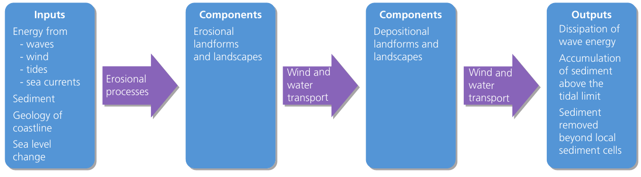
The coastal system includes:
- Inputs: Energy sources and materials entering the system
- Components/stores: Features where materials accumulate temporarily
- Flows/transfers: Processes that move energy and materials through the system
- Outputs: Energy and materials leaving the system
Think of the coastal system like a conveyor belt - materials and energy constantly flow through, but the overall structure can remain stable if inputs and outputs are balanced.
Dynamic equilibrium
When the inputs entering a coastal system balance with the outputs leaving it, the system exists in a state of dynamic equilibrium. This represents a natural balance where the coastal features remain relatively stable over time.
However, if any element within the system changes, this equilibrium can be disrupted. For example:
- Increased sediment deposition on a beach without corresponding sediment removal
- Changes in wave energy affecting erosion rates
- Alterations in sediment supply from rivers
When equilibrium is upset, coastal features begin to change. This disruption is known as feedback.
Feedback mechanisms
Feedback occurs when changes in one part of the system cause adjustments elsewhere. There are two types:
Negative feedback works to restore equilibrium and stabilise the system. The diagram below shows how this operates on a beach:
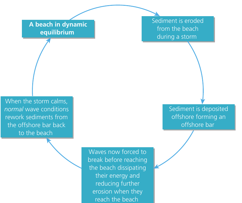
Worked Example: Negative Feedback on a Beach
Initial condition: Beach in equilibrium with normal wave conditions
Step 1: Disturbance During storms, increased wave energy erodes sediment from the beach and deposits it offshore, forming a bar.
Step 2: System response The newly formed bar causes waves to break earlier and further from shore, dissipating their energy before they reach the beach.
Step 3: Restoration When storm conditions subside, normal waves gradually move sediment back from the offshore bar to the beach, restoring the original profile.
Result: The beach returns to dynamic equilibrium through this self-regulating mechanism.
Positive feedback amplifies changes, moving the system further from equilibrium. While not shown in these materials, positive feedback can lead to accelerated coastal change.
Understanding coastal zones
The coastline can be divided into several distinct zones, each characterized by different processes and features. These zones are defined primarily by water levels and wave activity.
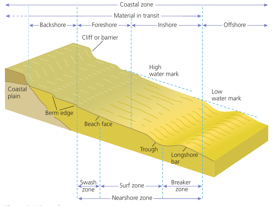
A helpful way to remember the coastal zones from land to sea is the mnemonic BFINO: Backshore, Foreshore, Inshore, Nearshore, Offshore.
Backshore
The backshore extends from the high water mark (HWM) to the landward limit where marine processes have influence. This zone typically only experiences marine activity during storm events when waves reach further inland than usual. During calm conditions, the backshore remains dry and is dominated by terrestrial processes.
Foreshore
The foreshore lies between the high water mark (HWM) and the low water mark (LWM). This represents the most active zone for marine processes during normal conditions (when storms are not occurring). The foreshore experiences regular tidal inundation, being submerged at high tide and exposed at low tide. It includes features such as:
- Beach face: the sloping surface extending down from the berm
- Berm edge: the upper limit of normal wave action
Inshore
The inshore zone extends seaward from the low water mark to the point where waves stop influencing the land beneath them. This area remains permanently underwater but shallow enough for wave activity to affect the seabed.
Nearshore
The nearshore area stretches from the HWM to where waves begin to break. It encompasses several important sub-zones:
Swash zone: This area experiences the turbulent rush of water washing up the beach after a wave breaks. The swash carries sediment up the beach slope.
Surf zone: Located between where waves break and where the swash operates, this zone is characterized by foamy, bubbly water as broken waves move toward the shore. Water moves up the beach as swash within this zone.
Breaker zone: This marks the area where approaching waves become unstable and break. Typically, waves break when water depth reaches approximately 5 to 10 metres. The exact location depends on wave height and seabed gradient.
Offshore
The offshore zone lies beyond where waves impact the seabed. In this deeper water area, wave activity becomes limited primarily to sediment deposition. Erosional processes are minimal, and the environment is dominated by deposition of fine materials settling from the water column.
Systems and processes in coastal environments
Understanding coastal systems requires examining the various elements that interact to shape coastal landscapes. These elements can be organized using the systems approach.
System components
Inputs into the coastal system include:
- Energy from waves, wind, tides, and sea currents
- Sediment from rivers, cliff erosion, and offshore sources
- Geological characteristics of the coastline
- Sea level changes
Components consist of:
- Erosional landforms and landscapes (such as cliffs, wave-cut platforms, caves)
- Depositional landforms and landscapes (such as beaches, spits, bars)
Flows/transfers include:
- Wind and water transport of sediment
- Erosional processes wearing away rock and sediment
- Mass movement of material downslope
Outputs from the system are:
- Dissipation (loss) of wave energy
- Accumulation of sediment above the tidal limit
- Sediment removed beyond local sediment cells
Sources of energy in coastal environments
The energy driving coastal processes comes from four main sources: waves, wind, tides, and currents. These energy sources power the weathering, erosion, and mass movement processes that shape coastal landscapes.
A useful mnemonic for remembering the energy sources is WWTC: Waves, Wind, Tides, Currents.
Wind
Wind serves as a crucial input into the coastal system. It functions both as a primary energy source for other processes and as a direct agent of erosion and sediment transport.
Spatial variations in wind energy occur because wind strength and duration vary from place to place. Locations experiencing persistently strong, uninterrupted winds tend to have higher wave energy. Although local weather patterns may cause short-term fluctuations in wind speed and direction, most coastlines have a prevailing wind direction – meaning the wind generally approaches from one dominant direction. This prevailing direction is important because it controls the direction that waves approach the coast, which in turn influences how coastal processes operate.
Prevailing wind direction refers to the direction from which wind typically blows most frequently at a particular location. This influences the angle at which waves approach the coastline.
The distance of open water over which wind blows uninterrupted is called the fetch.
Fetch refers to the distance of open water over which wind blows uninterrupted by major land obstacles. The length of fetch determines the magnitude (size) and energy of waves reaching the coast.
Longer fetch allows winds to transfer more energy to the water surface, generating larger, more powerful waves. Shorter fetch produces smaller waves with less energy. This explains why coastlines facing large ocean expanses often experience more energetic wave conditions than those sheltered by nearby landmasses.
Key coastal processes
Several processes work together to modify coastal landscapes. Understanding these three fundamental processes is essential for comprehending how coastal environments change over time.
Erosion is the wearing away of the Earth's surface by the mechanical action of processes including glaciers, wind, rivers, and marine waves.
Weathering is the breakdown and/or decay of rock at or near the Earth's surface, creating regolith (broken rock material) that remains in place (in situ) until moved by later erosional processes. Weathering can be mechanical, biological/organic, or chemical in nature.
Mass movement is the movement of material downhill under the influence of gravity. Rainfall may assist this process by adding weight and lubricating the material.
These processes interact continuously to shape coastal landforms. Weathering weakens rocks, erosion removes material, and mass movement transfers sediment downslope, all contributing to the constantly changing coastal landscape.
Think of these processes as a sequence: weathering prepares the material, erosion removes it, and mass movement transports it to new locations.
Remember!
Key Points to Remember:
-
Coastal environments function as open systems with inputs (energy and sediment), components (landforms), flows (transport processes), and outputs (energy dissipation and sediment removal)
-
Dynamic equilibrium occurs when inputs balance outputs, maintaining stable coastal features. Changes to any system element can disrupt this balance through feedback mechanisms
-
The coast is divided into five main zones: backshore (above HWM), foreshore (between HWM and LWM), inshore (below LWM), nearshore (contains swash, surf, and breaker zones), and offshore (deep water beyond wave influence)
-
Wind is a vital energy source for coastal systems, with prevailing wind direction controlling wave approach angles. Fetch (distance of open water) determines wave size and energy
-
Key processes shaping coasts include erosion (wearing away of surfaces), weathering (breakdown of rock in place), and mass movement (downhill sediment transfer)