Coastal Landscape Development - Deposition (AQA A-Level Geography): Revision Notes
Coastal Landscape Development - Deposition
Introduction to coastal deposition
Depositional landforms develop along coastlines where sediment (sand and shingle) accumulates faster than it is removed. This process typically occurs in locations where:
- Wave energy is relatively low
- There is an abundant supply of material from rapid coastal erosion elsewhere
- Waves are unable to carry sediment away effectively
Depositional features often form in low-energy environments where the rate of sediment supply exceeds the rate of removal. Understanding where and why deposition occurs is fundamental to recognizing these distinctive coastal landforms.
These depositional features create some of the most distinctive coastal landscapes and continue to evolve through ongoing coastal processes.
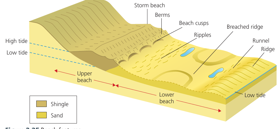
Beach characteristics
Beaches are locations where land meets the sea, consisting of accumulated sediment deposited between the low spring tide line and the highest point that storm waves can reach.
Beaches are primarily composed of two materials with distinctly different characteristics:
Sand:
- Creates gentle beach gradients (typically less than )
- Small particle size causes sand to become compact when wet
- Allows minimal water percolation
- Most water returns as backwash with little energy lost to friction
- Little sediment is transported down the beach
Shingle:
- Produces steeper beach gradients (generally between )
- Larger material size means water percolates rapidly through shingle
- Backwash loses energy to friction more quickly
- Less material is removed from the beach compared to sandy beaches
- The uneven surface further impedes backwash flow
The relationship between material size and beach gradient is therefore clear: larger sediment creates steeper beaches, whilst finer sediment produces gentler slopes.
Beach features and morphology
Beaches display several distinctive features created by wave action and tidal movements. Understanding these features helps explain how beaches function as dynamic systems.
Ridges and runnels:
- Form in the sand at the low-water mark
- Run parallel to the shoreline
- Broken by channels that drain water off the beach
Berms:
- Ridge formations that mark previous high tide positions
- Multiple berms show successively lower high tides
- Created as the tidal cycle progresses from spring tides to neap tides
- Built up by constructive waves
Beach cusps:
- Semi-circular depressions in the beach face
- Form when waves break directly onto the beach
- Develop where both swash and backwash are particularly strong
- Typically occur at the junction between shingle and sandy areas
- The sides of cusps channel incoming swash into the depression centre
- This creates stronger backwash that drags material down the beach, deepening the cusp
Ripples:
- Small-scale features developed on sandy surfaces
- Created by wave action or tidal currents
- Indicate the direction of water movement
Storm beaches:
- Ridge composed of the largest boulders
- Located above the normal high tide mark
- Created by the biggest waves during storm conditions
- Material is thrown up by the most powerful waves
- Below the storm beach are smaller ridges (berms) marking regular tides
Beach classification
Beaches can be classified according to their relationship with wave approach and sediment transport. The two main types demonstrate fundamentally different characteristics.
Swash-aligned beaches
These beaches have the following characteristics:
- Oriented parallel to the incoming wave crests
- Experience minimal longshore drift
- Typically found on irregular coastlines where longshore drift is restricted
- Waves approach the coast head-on rather than at an angle
Drift-aligned beaches
These beaches demonstrate different features:
- Oriented parallel to the direction of dominant longshore drift
- Experience considerable amounts of sediment transport along their length
- Initially develop where a coastline section is relatively straight
- Can extend beyond the coastline if there is a sudden direction change (such as at an estuary)
The concept of equilibrium is particularly significant for drift-aligned beaches. Without a continuous supply of new sediment, longshore drift would gradually remove material faster than it could be replaced, leading to beach erosion.
Spits, tombolos, bars and barrier beaches
Spits
A spit is an elongated, narrow ridge of land with one end joined to the mainland that extends out into the sea or across an estuary. It typically forms on drift-aligned coasts.
Spits are composed of sand and/or shingle. The precise mixture depends heavily on:
- The availability of different sediment types
- The wave energy required to transport the material
The formation of a spit follows a distinct process:
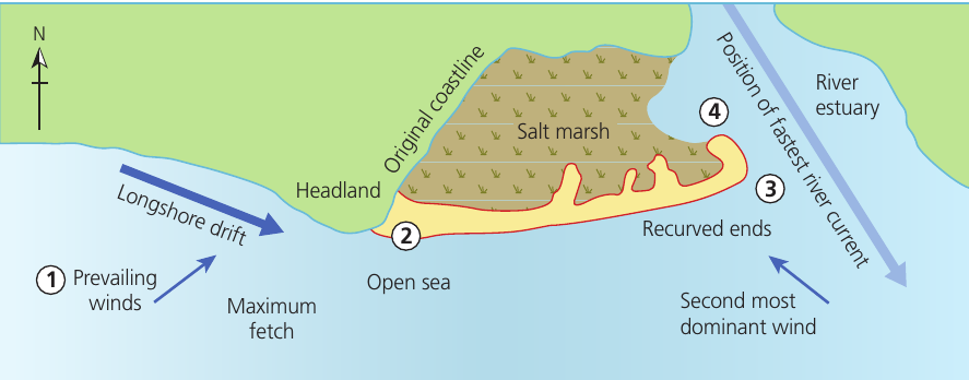
Worked Example: The Formation Process of a Spit
Stage 1: Prevailing winds and maximum fetch create waves from a particular direction (in this example, from the southwest). Material is transported from west to east along the coast through longshore drift.
Stage 2: Where the coastline changes to a more north-south orientation, sediment continues to be transported in the same direction. This causes a build-up of sand and shingle in the more sheltered water in the lee of the headland. As material accumulates above the high-water mark, it gives greater permanence to the developing feature.
Stage 3: Finer sediment is carried further eastward into deeper water at the estuary. As the water loses capacity to transport material further, this sediment is deposited, extending the ridge (spit) into the estuary.
Stage 4: The end of the spit begins to curve round as wave action transports material round into the more sheltered water. The second most dominant wind direction and fetch may contribute to this curving, pushing spit material back towards the mainland. The spit cannot extend completely across the estuary because the river's seaward flow and deeper central water inhibit growth.
Types of spits
Spits are classified as either simple or compound:
Simple spits:
- Are either straight or recurved at the end
- Do not have minor spits or multiple recurved ridges along their landward edge
Compound spits:
- May have similar basic features to simple spits
- Have a number of recurved ridges or minor spits along their landward side
- These features possibly mark positions where the spit terminated in the past
- Show evidence of the spit's development over time
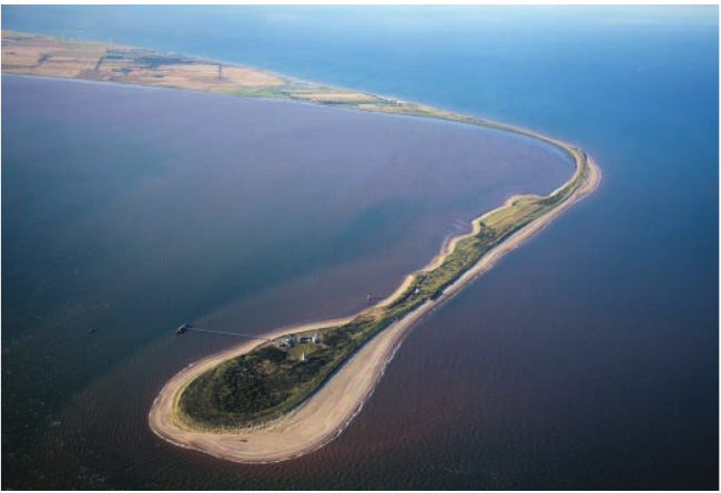
Notable examples of spits:
United Kingdom:
- Spurn Head (East Yorkshire) - illustrates typical spit features
- Borth (west Wales)
- Dawlish Warren (Devon)
- Orford Ness (East Anglia)
- Blakeney Point (Norfolk)
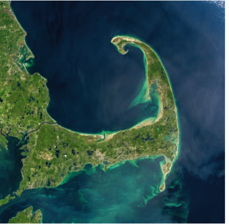
International:
- Cape Cod (Massachusetts, USA) - a compound spit showing distinctive hooked shape
- Farewell Spit (New Zealand)
- Homer Spit (Alaska)
Salt marshes and sand dunes on spits
As spits mature and increase in size, additional features may develop that significantly alter the coastal environment:
Sand dunes:
- Form when deposited sand dries out
- Material is blown to the landward side of the spit
- Vegetation (such as marram grass) colonises and stabilises the dunes
- Create increasingly large, sheltered areas as the spit grows
Salt marshes:
- Develop in the sheltered area between the land and the spit
- Form where low-energy, gentle waves operate
- Finer material (silt and clay) is deposited in these calm conditions
- Vegetation colonises these deposits
- Gradually build up to create distinctive salt marsh ecosystems
Tombolos
A tombolo is a type of spit that connects an island to the mainland.
Formation occurs when:
- The coastline changes shape, causing a spit to grow towards an offshore island
- Material continues to be deposited until the connection is complete
- The former island becomes joined to the mainland
Example: Chesil Beach
The finest example of a tombolo in Britain is Chesil Beach on the south coast of England. This feature:
- Links the Isle of Portland to the mainland
- Extends approximately 30 kilometres in length
- Represents one of the most beautiful and frequently photographed tombolos worldwide
Other notable tombolos include the Angel Road at Shodo Island, Japan.
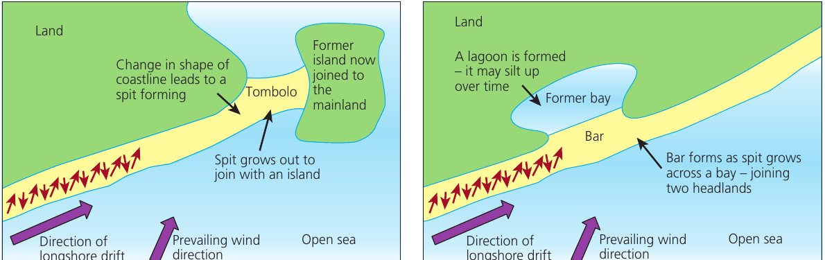
Bars
A bar forms when a spit extends across a bay where there is no strong flow of water from the landward side.
The formation process involves:
- A spit developing along the coast
- The spit extending across a bay between two headlands
- Without strong water outflow, the spit can grow completely across the opening
- The former bay becomes enclosed, creating a lagoon
- Over time, the lagoon may gradually fill with sediment (silt up)
Offshore bars:
A slightly different feature occurs when a ridge of beach material remains semi-submerged. This accumulates seaward of the breaker zone and is known as an offshore bar.
Some offshore bars may result from onshore migration of material from the seabed during rising sea levels following the last ice age, rather than from spit development. Research suggests that a combination of onshore migration and longshore drift may have formed features like Chesil Beach, rather than simple spit extension.
Barrier beaches and barrier islands
A barrier beach or barrier island is an elongated bank of deposited sand or shingle that lies parallel to the coastline and remains above water at high tide.
Characteristics include:
- Parallel orientation to the coast
- Not submerged by incoming tides
- High enough to allow sand dunes to develop on top
- Create sheltered areas (lagoons or coastal marshes) between the barrier and the land
- In tropical locations, mangrove swamps may develop in the sheltered zone
Formation:
Barrier beaches may form through:
- The breaching of a spit by wave action
- Constructive waves pushing a bar of material towards the land
Example: The Lido of Venice
One of the most famous barrier beaches is the Lido of Venice, which protects the city of Venice from the Adriatic Sea.
Other notable features:
The longest spit in the world is the Arabat Spit in the Sea of Azov. This remarkable feature:
- Functions as a bar
- Connects towns in Ukraine to the north and Crimea to the south
- Demonstrates the scale that these depositional features can achieve
Dynamic coastal landscapes
Understanding coastal landscapes requires looking beyond current processes to consider historical development. The diverse coastal landscapes we observe today result from complex interactions of various landforms in each location.
Where sea and land meet, characteristic features include:
- Bays and estuaries
- Beaches
- Deltas
- Dunes
- Mud flats and salt marshes
It is crucial to recognise that with large and ever-changing amounts of energy available from wind-driven waves, tides and currents, coastal landscapes are dynamic systems that constantly change. These are not static features but continue to evolve in response to ongoing processes.
The coastal landscapes visible today are products of factors that shaped them during the Holocene period (approximately the last 12,000 years since the end of the last glacial period). Multiple factors have been important in producing present coastal landscape features and continue to operate today.
Key factors influencing coastal landscape development:
- Local tectonic processes - including land uplift and subsidence
- Sea level change - both global and local variations
- Climatic change - natural variations and human-enhanced changes
- Human activity - affecting sediment supply and coastal processes
- Changing ocean currents and wave regimes - altering energy distribution
- Natural disasters or events - such as storms or tsunamis
- Changing sediment sources - affecting material availability and types
- The changing nature of human activity - including coastal development and management
All these factors, and more, have continually changed over millennia. Each has left distinctive marks as features in today's coastal landscapes. Contemporary coastal processes will inevitably continue to alter and modify these features further into the future.
Coastal sand dunes
Coastal sand dunes are accumulations of sand shaped into mounds by the action of wind.
Sand dunes represent a dynamic coastal landform. Like other depositional features, they can be studied using a systems approach.
Essential requirements for sand dune formation:
- A plentiful supply of sand
- Strong onshore winds to transport the sand
- A large tidal range (exposing extensive areas of sand at low tide)
These conditions allow sand to be blown inland from the beach. As the sand accumulates and vegetation colonises the dunes, they become increasingly stable features of the coastal landscape.
Key Points to Remember:
-
Beaches form where sediment accumulates between tides, with sand creating gentle gradients and shingle producing steeper beaches due to differences in percolation and backwash.
-
Beach features include ridges, runnels, berms, cusps and storm beaches, each created by specific combinations of wave action, tidal movement and sediment characteristics.
-
Spits are elongated ridges that extend from the coast through longshore drift, developing recurved ends in sheltered water and potentially forming salt marshes and sand dunes as they mature.
-
Tombolos connect islands to the mainland, bars enclose bays to create lagoons, and barrier beaches run parallel to the coast, creating sheltered environments behind them.
-
Coastal landscapes are dynamic systems shaped by multiple factors over thousands of years, including sea level change, tectonic processes, climate, human activity and natural events - they continue to evolve constantly.