Emergent Coastlines (AQA A-Level Geography): Revision Notes
Emergent Coastlines
What are emergent coastlines?
Emergent coastlines develop when land rises relative to sea level, or when sea level falls relative to the land. This exposes coastal features that were previously at or below sea level, creating distinctive landforms that provide evidence of past sea levels and coastal processes.
These coastlines show features that were formed by marine processes but now sit above the current level of the sea. Understanding emergent coastlines helps us reconstruct past environmental conditions and predict future coastal changes.
The study of emergent coastlines provides valuable insights into historical sea level changes and helps geologists understand the dynamic relationship between land and sea over geological time scales.
Key emergent coastal features
Fjords
Fjords are spectacular drowned glacial valleys that have been flooded by rising sea levels following the last ice age. These features demonstrate how sea level changes can create emergent characteristics in previously glaciated landscapes.
Key characteristics of fjords include:
- Deep U-shaped valleys carved by glaciers
- Not deepest at the mouth
- Glacial rock basin with a shallower section at the entrance (threshold)
- The threshold formed when glacier ice became thinner as it contacted the sea, reducing erosional power
Notable Examples of Fjords:
Sogne Fjord, Norway
- Nearly 200 km long
- One of the world's longest and deepest fjords
- Demonstrates classic glacial valley characteristics
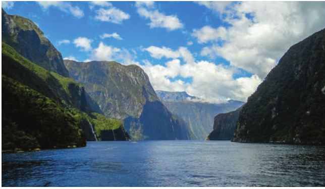
Milford Sound, New Zealand
- Famous for its dramatic cliffs and waterfalls
- Receives over 7 metres of rainfall annually
- Created by multiple glaciation events
Dalmatian coasts
A Dalmatian coast forms where valleys run parallel to the coastline rather than at right angles to it. When sea levels rise, these valleys become flooded, creating a distinctive pattern of islands and peninsulas that align parallel to the mainland shore.
This type of coast takes its name from the Croatian coast along the Adriatic Sea, where this pattern is particularly well developed. The parallel alignment creates a unique coastal geography that distinguishes it from other emergent coastal types.
Raised beaches
A raised beach is an area of former wave-cut platform and beach that now sits at a level higher than the present sea level. These features provide clear evidence of past sea levels and coastal positions.
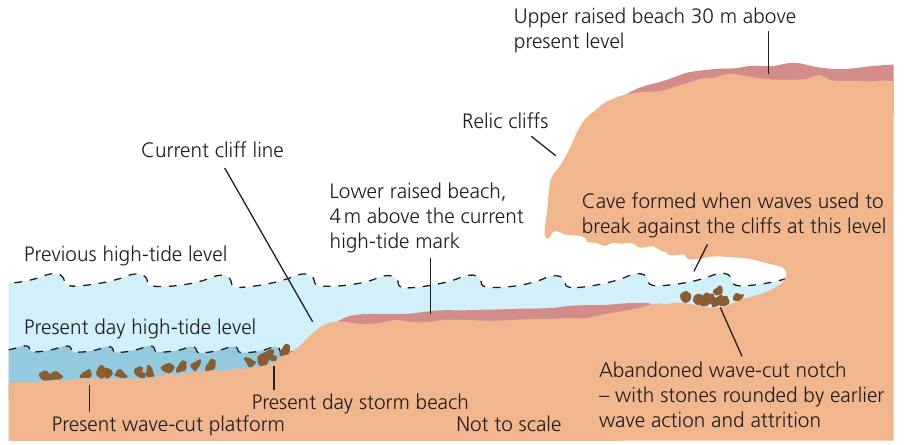
Raised beaches commonly display several distinctive features:
- Old cliff lines (relic cliffs) behind the raised beach
- Wave-cut notches in the relic cliffs
- Sea caves, arches and stacks formed by past wave action
- Rounded stones showing evidence of attrition
- Storm beach deposits now above the active zone
Distribution in the UK:
Raised beaches are particularly common around the coasts of western Scotland, where three distinct levels have been identified:
- 8 metres above present sea level
- 15 metres above present sea level
- 30 metres above present sea level
These are approximate heights due to differential uplift across the region. The variation in height reflects the complex interaction between isostatic rebound and eustatic sea level changes since the last glaciation.
Case Study: Isle of Arran, Scotland
On the west coast of the Isle of Arran, north of Drumadoon, a well-developed raised beach demonstrates these features clearly.
Key Features:
- Sits approximately 4-5 metres above present sea level
- Contains a relic cliff with visible erosional features
- Displays arches, stacks and caves, including the famous King's Cave
- Shows clear evidence of former wave action at this higher level
Interpretation: This raised beach initially appears to suggest that sea levels were once higher. However, we know that sea levels have actually risen considerably (eustatically) since the end of the last ice age. This means the land itself must have risen even faster than the sea level rise through isostatic uplift - a phenomenon where land rebounds after the weight of ice sheets is removed.
Marine platforms and terraces
A marine platform (or marine terrace) is an area of gently sloping, formerly submerged land that has been exposed by either uplift of the land or lowering of sea level.
The key distinction between raised beaches and marine platforms relates to the gradient:
- Raised beaches: Relatively flat former wave-cut platforms with beach deposits
- Marine platforms: More gently sloping areas of exposed continental shelf
Marine platforms may extend for considerable distances both offshore and inland, representing what was once the shallow sea floor.
Impacts of climate change on coasts
Historical sea level changes
Sea level has risen consistently over the past 10,000 years following the end of the last ice age. However, the rate of rise has accelerated significantly in recent decades, creating new challenges for coastal management.
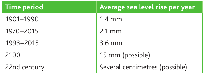
Acceleration in Sea Level Rise:
The data shows a clear acceleration pattern:
- 1901-1990: Average rise of 1.4 mm per year
- 1970-2015: Average rise of 2.1 mm per year
- 1993-2015: Average rise of 3.6 mm per year
This represents more than a doubling of the rate in just over a century, indicating the increasing impact of climate change on global sea levels.
Future predictions
Future sea level rise remains uncertain, but most scientific predictions indicate substantial increases by 2100. Current estimates suggest:
- By 2100: Rise of 30 cm to 110 cm above 1990s levels
- 22nd century: Continued significant increases of several centimetres possible
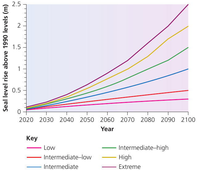
Factors Contributing to Prediction Uncertainty:
The wide range of predictions reflects several complex factors:
- Uncertainty about future greenhouse gas emissions scenarios
- Difficulty predicting ice sheet behaviour during warming conditions
- Complex modelling of thermal expansion effects in different ocean regions
- Unknown effectiveness of future climate mitigation efforts and policy implementations
Scientists continue to refine these models as more data becomes available and our understanding of climate systems improves.
Causes of sea level change
Sea level changes result from two main processes:
1. Increases in ocean volume
This occurs through two mechanisms:
- Thermal expansion: As ocean temperatures warm due to climate change, water expands, taking up more space
- Ice melt: Water currently stored in ice sheets and glaciers is released into the oceans as ice melts
2. Subsidence of the coast
Some coastal areas are sinking relative to sea level, particularly in:
- Southeast England
- East coast margins
- North Sea basin in the east and southeast
This subsidence contrasts with the gradual uplift occurring in northern and western UK areas, which continues as a result of ice sheet removal following the last ice age.
UK-specific impacts
The UK faces particular challenges because different regions are experiencing contrasting changes:
- North and west: Gradual uplift continues from post-glacial isostatic rebound
- Southeast: Gradual subsidence is occurring
Southeast England Vulnerability:
In southeast England, the rise in sea level relative to the land may be greater than the global average, combining both:
- Global sea level rise (eustatic change)
- Local subsidence (isostatic change)
This double impact could lead to increased coastal flooding and erosion unless effective mitigation measures are implemented. Coastal communities in this region face some of the highest risks in the UK from future sea level rise.
Key Points to Remember:
-
Emergent coastlines form when land rises relative to sea level or sea level falls, exposing former marine features above the current sea level
-
Raised beaches are former wave-cut platforms now above sea level, commonly found at 8m, 15m and 30m in western Scotland, formed by isostatic uplift exceeding eustatic sea level rise
-
Fjords are drowned glacial valleys with characteristic U-shapes and shallow thresholds at their mouths
-
Sea level rise is accelerating - from 1.4mm/year (1901-1990) to 3.6mm/year (1993-2015), with predictions of 30-110cm rise by 2100
-
Two main causes of sea level rise are thermal expansion of warming oceans and melting of ice sheets and glaciers, with UK southeast particularly vulnerable due to local subsidence
-
Understanding emergent coastlines helps us reconstruct past environmental conditions and predict future coastal changes