Erosional Landforms (AQA A-Level Geography): Revision Notes
Erosional landforms
Glaciers are incredibly powerful agents of erosion that dramatically reshape the landscapes through which they move. The enormous erosive power comes from the combination of ice, meltwater, and rock debris that work together to carve distinctive features into the bedrock. These erosional landforms provide clear evidence of past glacial activity and include some of the most spectacular mountain scenery on Earth.
The erosional landforms created by glaciers are among the most dramatic features in mountainous regions. Their distinctive shapes - from the armchair-shaped corries to the massive U-shaped valleys - make them easily recognizable in the landscape and provide valuable evidence of past ice ages.
Corries and associated landforms
What is a corrie?
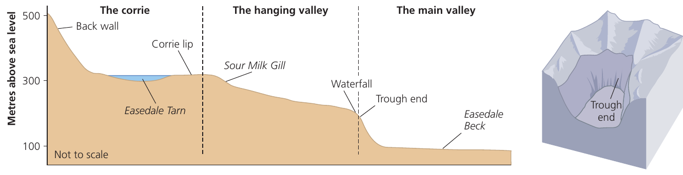
A corrie (also called a cirque) is an armchair-shaped rock hollow with a steep back wall and an over-deepened basin. It has a rock lip at its front edge and often contains a small lake called a tarn after the ice has melted.
In the British Isles, corries mainly form on north-, northeast- and east-facing slopes. These locations receive lower levels of insolation, allowing snow to accumulate more readily and persist for longer periods.
The size of corries varies depending on local topography and the size of glaciers that formed them. For example, Red Tarn in the English Lake District sits in a corrie with a back wall rising 300m to the summit of Helvellyn, and measures approximately 300-400 metres across.
How do corries form?
The development of corries involves several interconnected glacial processes working together over thousands of years.
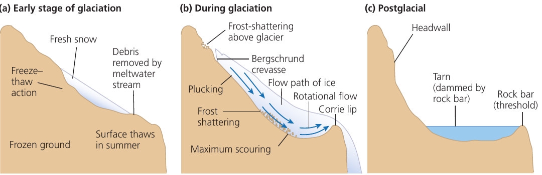
Stage 1: Early glaciation
- The process begins with nivation acting on a shallow, pre-existing hollow on a mountainside
- Nivation involves freeze-thaw weathering beneath and around snow patches
- Debris produced by freeze-thaw action gets removed by meltwater streams in summer
- The frozen ground at the base of the hollow restricts water drainage
- This can be a slow process that continues across several glacial periods within an ice age
Stage 2: Active glaciation
- As the hollow deepens, snow accumulates more easily and becomes compacted into ice
- A deep crack called a bergschrund crevasse opens between the ice and the back wall
- Frost shattering intensifies on the back wall above the glacier, steepening it progressively
- Plucking occurs as ice freezes onto the back wall and pulls away blocks of rock as it moves
- The bowl shape of the hollow creates rotational flow in the ice
- This rotational movement, combined with plucking and frost-shattered debris, abrades and over-deepens the floor of the hollow, creating the characteristic corrie basin
- The thinner ice at the edge of the corrie has less erosive power, so less downcutting occurs here
- This creates a rock lip (threshold) at the front of the corrie
- In some cases, moraines deposited when the glacier's snout remained in one position can increase the height of this threshold
Stage 3: Post-glaciation
- During interglacial periods when ice melts, the corrie fills with meltwater and rainwater
- This creates a small lake called a tarn, held back by the rock lip
- The steep headwall remains as a distinctive feature of the landscape
Arêtes
When two corries develop back-to-back or alongside each other on a mountain, the erosion of their back walls creates a narrow, steep-sided ridge between them.
An arête is a narrow, knife-edge ridge formed when two corries erode backwards towards each other. Over many glaciations, the ridge becomes increasingly narrow and steep-sided.
A classic UK example is Striding Edge above Red Tarn on Helvellyn in the Lake District.
Pyramidal peaks
When more than two corries develop on different sides of a mountain, the central mass of rock between them survives as a pointed summit.
A pyramidal peak is a sharp, pointed mountain summit formed when three or more corries erode backwards into a mountain from different sides. The peak takes on a very sharp appearance due to frost shattering.
The Matterhorn in the Alps (bordering Switzerland and Italy) is one of the most famous examples of a pyramidal peak.
Glacial troughs and associated landforms
Formation of glacial troughs
As glaciers flow down from upland areas, they follow pre-existing river valleys. However, the erosive power of glaciers transforms these valleys dramatically.
Glaciers straighten, widen and deepen river valleys as they move through them. The original V-shaped river valley becomes transformed into the characteristic U-shaped (or trough-shaped) valley typical of glacial erosion.
The difference in erosive power between rivers and glaciers is striking. While rivers carve narrow V-shaped valleys over millions of years, glaciers can transform these same valleys into wide U-shaped troughs in just tens of thousands of years. This is because ice, working together with massive volumes of meltwater and rocky debris carried beneath the glacier, can erode far more effectively than flowing water alone.
Characteristics of glacial troughs
Major features of glacial troughs include:
U-shaped cross-profile
- Steep valley sides
- Wide, flat valley floor
- This contrasts sharply with the narrow V-shape of river valleys
Stepped long profile
- Rather than a smooth gradient, glacial troughs have an irregular long profile
- Alternating steep sections (steps) and flatter sections with rock basins
- These irregularities create a stepped appearance when viewed in profile
Rock basins and ribbon lakes
As both extending flow and compressing flow occur in glaciers, the amount of erosion varies along the valley length. Where compressing flow is present, the glacier applies greater pressure to the valley floor, leading to over-deepening of certain sections.
Rock basins are over-deepened sections of the valley floor created by increased erosion. Scientists suggest this over-deepening occurs at the confluence of glaciers, in areas of less-resistant geology, or in zones of well-jointed rocks.
After glaciation, these rock basins may fill with water to create long, narrow lakes called ribbon lakes. Wast Water in the Lake District is an excellent example of a ribbon lake.
Trough ends
Some glacial valleys end abruptly at their heads with a steep wall. This feature is known as a trough end, and a number of corries typically lie above it. The trough end marks where the main glacier originated from several corries.
Hanging valleys
Hanging valleys are tributary valleys that enter the main glacial trough high up on the valley side. They are either pre-glacial tributary river valleys that were not glaciated, or smaller tributary glacial valleys.
Formation of hanging valleys
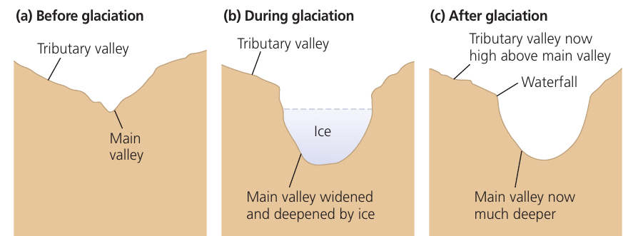
Before glaciation, tributary river valleys joined main river valleys at the same level. However, during glaciation, the situation changed dramatically.
Formation Process: How Hanging Valleys Develop
- Before glaciation: Tributary river valleys join the main river valley at the same level
- During glaciation: The tributary valleys contain either no ice or much smaller glaciers than the main valley
- Differential erosion: The massive glacier in the main valley carves it much wider and deeper through powerful erosion, while the tributary valley floor remains relatively unchanged at its original higher level
- After glaciation: The tributary valley is left "hanging" high above the deepened main valley floor, with streams plunging down as spectacular waterfalls
The tributary valleys contained either no ice (if they remained as river valleys) or much smaller glaciers than the main valley. Consequently, the tributary valleys experienced far less erosion than the main valley.
After the ice retreated, the tributary valley was left "hanging" high above the deepened main valley floor. Streams now plunge from the hanging valley into the main valley, often creating spectacular waterfalls.
UK examples include:
- The valley of Church Beck, which flows down into Coniston Water in the Lake District as a hanging valley
- Sour Milk Gill, which cascades down from Easedale Tarn to meet Easedale Beck in the main valley below
Truncated spurs
Before glaciation, river valleys typically have interlocking spurs - ridges of land that project into the valley from alternating sides.
As glaciers moved down valleys, they had the power to remove these projecting spurs rather than wind around them like rivers do. The glacier essentially sliced off these ridges, creating steep valley sides.
Truncated spurs are areas of land that originally projected from the valley side (spurs) but have been removed by the glacier, leaving steep-sided valley walls.
Small mounds of resistant rock on the valley floor are not always completely removed. As the glacier moves over these obstacles, distinctive features called roches moutonnées are created.
Roches moutonnées
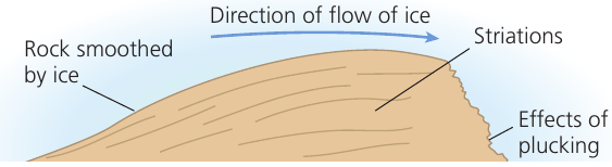
Roches moutonnées are small, streamlined mounds of resistant bedrock on the valley floor. They have an asymmetric shape with a smooth up-valley side (stoss slope) and a jagged down-valley side (lee slope).
Formation of roches moutonnées
These features form through two different erosional processes acting on opposite sides of the rock obstacle:
Up-valley (stoss) side:
- As ice flows up and over the obstacle, it grinds against the rock
- Abrasion by rock fragments embedded in the ice smooths and polishes this side
- This creates a gentle, smooth slope facing up-valley
- Striations (scratches) may be visible on the smoothed surface, showing the direction of ice flow
Down-valley (lee) side:
- On the downstream side, ice freezes onto the rock surface
- As the glacier continues moving, this frozen ice pulls away blocks of rock
- This process, called plucking, creates a steep, jagged surface
- The lee slope appears rough and broken compared to the stoss side
The asymmetric shape of roches moutonnées makes them valuable indicators of ice flow direction. The smooth, polished stoss slope always faces the direction from which the ice came, while the rough, jagged lee slope faces the direction of ice movement. Geologists use these features to reconstruct past ice flow patterns.
Roches moutonnées are relatively small features, typically up to a few tens of metres in length and less than 5 metres in height.
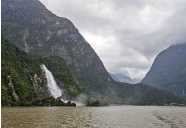
Fjords
After the ice ages ended and glaciers retreated, global sea levels rose as the ice melted. This rise in sea level caused the flooding of many coastal glacial valleys.
Fjords are drowned glacial valleys that were flooded when sea levels rose after the ice ages. They retain the characteristic U-shaped cross-section and over-deepened profile of glacial troughs.
Fjords are found on the coasts of Norway and southwest New Zealand (where Milford Sound is a famous example). These spectacular features demonstrate how glacial erosion created valleys that extended below current sea level.
Key Points to Remember:
-
Corries are armchair-shaped hollows formed by nivation, frost shattering, plucking and rotational ice flow. They often contain tarns (small lakes) after glaciation.
-
Glacial troughs are U-shaped valleys created as glaciers widen and deepen pre-existing river valleys. They feature steep sides, wide floors, stepped long profiles, and may contain rock basins filled with ribbon lakes.
-
Hanging valleys are tributary valleys left high above the main valley floor because the main glacier eroded much more deeply than smaller tributary glaciers or rivers.
-
Roches moutonnées are small asymmetric rock bumps with smooth stoss slopes (created by abrasion) and jagged lee slopes (created by plucking) that show the direction of ice flow.
-
Arêtes and pyramidal peaks form when multiple corries erode backwards into mountains from different directions, creating knife-edge ridges and sharp summits.