Nature and Distribution of Cold Environments (AQA A-Level Geography): Revision Notes
Nature and Distribution of Cold Environments
Introduction to cold environments
Cold environments encompass a wide range of landscapes, climates and ecosystems across the globe. These areas are characterised by freezing temperatures for much or all of the year, limited precipitation (mainly as snow), and unique adaptations in both physical systems and living organisms. Understanding cold environments requires examining their distribution patterns, climate characteristics, and the physical processes that shape them.
Cold environments are found in locations where temperatures remain consistently low enough to support ice, snow or permafrost. The term covers diverse areas, from the polar ice sheets of Antarctica and Greenland to high-altitude mountain regions, and from periglacial tundra zones to areas with active glaciers. Whilst all these environments share the common feature of cold temperatures, they differ significantly in their specific characteristics.
These environments are shaped by the continuous interaction of physical processes driven by energy inputs. As systems, they tend towards dynamic equilibrium, constantly adjusting to changes in energy and material flows. A crucial aspect of cold environments is their sensitivity to temperature changes, exemplified by feedback mechanisms.
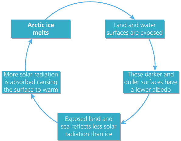
The Ice-Albedo Feedback Loop
One important feedback mechanism is the ice-albedo feedback loop. When Arctic ice melts, darker land and water surfaces become exposed. These darker surfaces have a lower albedo (reflectivity) than ice, meaning they absorb more solar radiation rather than reflecting it back into space. This increased absorption causes further warming, which leads to more ice melting, creating a positive feedback cycle that amplifies the initial warming effect.
Fragile environments are those that are easily damaged or disturbed and then difficult to restore once destroyed. Cold environments are particularly fragile because of their sensitivity to temperature changes and slow recovery rates.
Classification of cold environments
Cold environments can be grouped into four main categories based on their latitude, altitude and physical characteristics. Each type has distinct features that distinguish it from the others.
Polar regions
Polar environments are found at the Earth's northern and southern extremes, almost entirely within the Arctic and Antarctic circles (above approximately 66° north and south of the Equator). These are the coldest places on Earth.
The Arctic region consists primarily of the Arctic Ocean, which surrounds the North Pole, along with northern parts of Asia, Europe and North America. Key characteristics include:
- A central polar area continuously covered by drifting sea ice, averaging 3 metres thick
- Sea ice extent that doubles during winter, reaching 13 to 14 million km²
- A wide range of climates, but continuously cold conditions throughout
- Mean annual temperatures ranging from +4°C to -28°C
- Precipitation levels varying considerably, with the Atlantic area receiving significantly more than other regions (overall average around 100 mm annually)
The Antarctic region encompasses the massive frozen wilderness of Antarctica, surrounded by the Southern Ocean. This region includes:
- The vast ice sheet covering 13 million km² of the continent
- Periodically frozen expanses of the Southern Ocean
- Much colder conditions than the Arctic due to the large landmass and ocean expanse
- Strong westerly winds driven by temperature differences between interior and coastal areas
- Sea ice that develops rapidly in winter (from about 2 million km² in February to around 16 million km² in September)
- The coldest location on Earth: the South Polar Plateau, with mean annual temperatures in places around -55°C
The Antarctic interior contains mountains and high plateaux where atmospheric circulation patterns and high altitude combine to create Earth's most extreme cold. The extent of winter sea ice around Antarctica is increasing, whilst in the Arctic it is shrinking, showing different regional responses to climate change.
Alpine environments
Alpine environments are found in high-altitude mountain areas and are among the most recognisable cold landscapes. They occur in regions where elevation is sufficient to maintain snow and ice throughout the year.
Key characteristics of alpine environments:
- High relief, with peaks often exceeding 3,000 metres above valley floors
- Associated with tectonically active mountain ranges (Himalaya, Karakoram, Tibet, Rockies, Cascades, Andes, New Zealand Alps)
- Spectacular glaciated features created by the combination of tectonic uplift and rapid erosion by water and ice
- Temperatures that drop below freezing for significant periods, often below -10°C, but summer temperatures can rise well above freezing
- At lower latitudes, summer temperatures regularly exceed 20°C
In older, more tectonically stable mountain ranges, relief is lower and glaciated features have been softened and smoothed by subsequent weathering and erosion. These include areas that were formerly glacial, such as mountains in northern and western Britain. Today, alpine regions with active glaciers occur at almost all latitudes but must be at high enough altitude for snow and ice to remain year-round.
Alpine landscapes develop through a sequence over time. An Ergodic model (Flint, 1971) suggests that alpine landscapes evolve from pre-glacial river valleys, which are then modified during glacial and interglacial cycles. Recurring glacial erosion takes these landscapes through several stages to create mature alpine scenery.
Periglacial regions (tundra)
Tundra refers to the climate and vegetation type found across extensive areas of northern Siberia, Scandinavia, Canada and Alaska. Tundra lies between the region of continual snow and ice of the polar regions and the northern limit of tree growth. Similar ecosystems are found around the ice-free fringes of Antarctica and at high altitudes above the tree line in the Alps, Rockies, Andes and Himalayas.
Periglacial regions are generally located in dry, high-latitude areas that are not permanently covered by snow and ice, but are cold enough for periglacial processes to occur. Current active periglacial regions with tundra ecosystems include:
- Northern Alaska and Canada
- Northern Scandinavia
- Siberia
- Arctic Ocean islands such as Spitsbergen
In these areas, cold conditions create permanently frozen ground known as permafrost, which is often overlain by a more mobile unfrozen layer called the active layer. The active layer thaws during summer months, allowing limited biological activity.
Permafrost is frozen ground where temperatures remain below 0°C for at least two consecutive years. It can extend to considerable depths beneath the surface. During the brief summer period, only the surface layer (active layer) melts, whilst the permafrost below remains frozen, creating unique soil and landscape conditions.
Some areas in lower latitudes but at higher altitudes also experience periglacial processes, though these tend to be less extensive than high-latitude regions.
Glacial environments
Glaciers are large masses of ice on land that move downhill due to the influence of gravity. Ice sheets are continental-sized masses of ice covering at least 50,000 km² that are dome-shaped with ice flowing outward from the centre. Ice sheets can be up to 2,000 metres thick today.
Glacial environments are areas currently covered by ice sheets and glaciers. These are permanently cold enough for substantial masses of ice to remain on the landscape throughout the year. The two most significant areas are the ice sheets of Antarctica and Greenland.
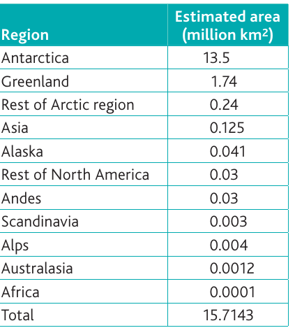
Currently, about 10% of the land area of Earth is covered by ice, including glaciers, ice caps and ice sheets totalling over 15 million km². The table above shows how this ice is distributed globally, with Antarctica and Greenland accounting for the vast majority.
Climate characteristics of cold environments
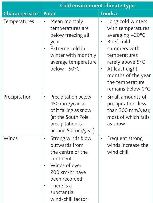
The climate of cold environments varies depending on location, but all share common features of low temperatures, limited precipitation, and often strong winds. The main climate types are polar and tundra.
Temperature patterns
Polar climates experience the most extreme cold:
- Mean monthly temperatures remain below freezing throughout the entire year
- Winter conditions are extremely harsh, with monthly average temperatures dropping below -50°C
- Even during summer months, temperatures rarely rise significantly
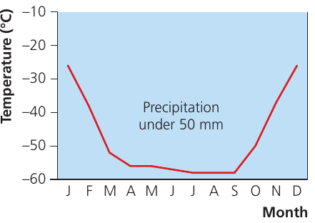
- At the South Pole, precipitation is minimal (around 50 mm per year)
Tundra climates are slightly less extreme but still very cold:
- Long, harsh winters with temperatures averaging around -20°C
- Brief, mild summers when temperatures rarely exceed 5°C
- At least eight months of the year see temperatures below 0°C
- Mean monthly temperatures do not exceed 10°C, which is just warm enough for the surface layer of permafrost (active layer) to melt
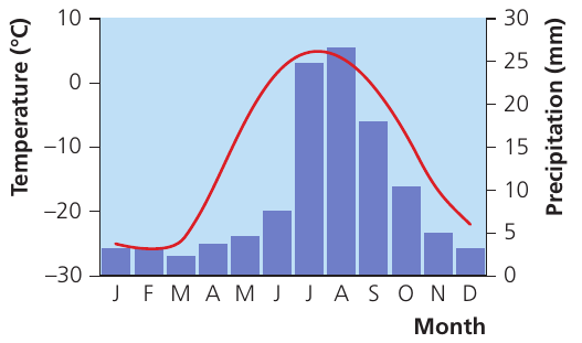
The climate graphs show clear differences between tundra (Barrow, Alaska) and polar regions (Amundsen-Scott Station, South Pole). Tundra areas experience some summer warming and slightly higher precipitation during warmer months, whilst polar regions remain extremely cold year-round with minimal precipitation.
Precipitation levels
Cold environments receive very little precipitation:
Polar regions:
- Annual precipitation below 150 mm per year
- All precipitation falls as snow
- At the South Pole, precipitation is around 50 mm per year, making it technically a desert
- Some areas can be classified as polar deserts due to extremely low moisture levels
Tundra regions:
- Small amounts of precipitation, less than 300 mm per year
- Most precipitation falls as snow
- Slightly higher precipitation than polar regions, particularly during summer months
The low precipitation in cold environments results from several factors: the high-pressure systems that often dominate these regions, the limited moisture-holding capacity of cold air, and the distance from major moisture sources.
Wind conditions
Strong winds are characteristic of cold environments and significantly increase the severity of the cold through wind chill effects:
Polar regions:
- Strong winds blow outwards from the centre of continents
- Wind speeds exceeding 200 km/hr have been recorded in Antarctica
- Substantial wind-chill factor makes temperatures feel even colder
- Katabatic winds form when masses of cold, dense air flow down valleys and across ice sheets
- These winds can exceed 200 km/hr where there are few obstacles
- Winds whip up powdery snow, creating frequent blizzards and white-outs
Tundra regions:
- Frequent strong winds increase the wind chill effect
- Winds affect vegetation patterns and snow distribution
- Strong desiccating winds contribute to the harsh growing conditions for plants
Causes of cold climates
Several interconnected factors create and maintain cold climates in polar, alpine and periglacial regions. Understanding these causes helps explain why certain areas remain cold whilst others at similar latitudes may be warmer.
Low level of insolation
Insolation is the radiant energy emitted by the Sun that reaches Earth's surface as incoming solar radiation. In polar regions, insolation levels are extremely low, which is the primary reason for cold temperatures.
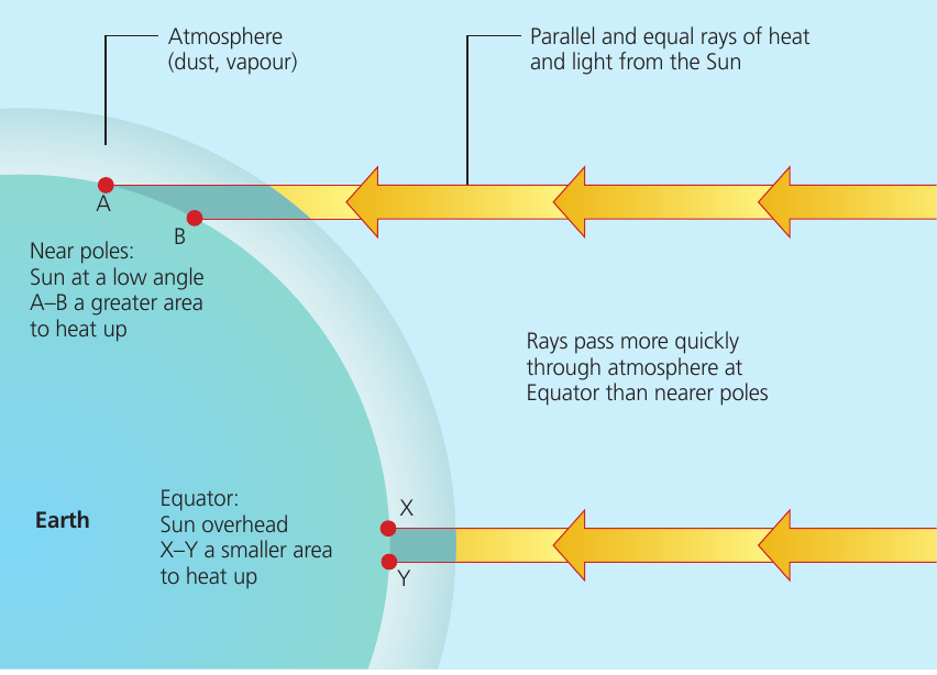
During summer months, the Sun remains at a low level in the sky even though there are periods of continuous sunlight. The rays strike the surface obliquely, which means:
- There is a wider surface area to heat (compare area A-B at the poles to area X-Y at the Equator in the diagram)
- The longer passage through the atmosphere allows increased absorption, scattering and reflection of radiation
- Less insolation actually reaches the surface to provide heating
This contrasts sharply with equatorial regions where the Sun is overhead, rays strike perpendicular to the surface, and pass more quickly through the atmosphere, resulting in much greater heating.
In winter, there is a corresponding period when there is no incoming solar radiation at all because the Sun does not appear above the horizon, leading to extreme cold.
High albedo effect
In areas of continuous snow cover, much of the incoming solar radiation is reflected off the ice and snow surface rather than being absorbed. This is due to the albedo effect:
- Albedo measures the reflectivity of a surface
- Ice and snow have very high albedo values (reflecting up to 80-90% of incoming radiation)
- This reduces the amount of energy available to warm the atmosphere
- The high albedo effect is particularly significant in ice-covered polar regions
The ice-albedo feedback mechanism (shown earlier) demonstrates how changes in ice cover can amplify warming or cooling trends.
High pressure systems
High-pressure systems frequently dominate polar regions:
- Frontal weather systems rarely penetrate these areas
- This results in very low levels of precipitation
- High-pressure systems are associated with clear skies and calm conditions
- However, they also contribute to temperature extremes
Coolness of the air
The extremely cold air in polar regions has a very low capacity to hold water vapour:
- Cold air can only hold limited amounts of moisture
- When precipitation occurs, it is often little more than very light, powdery snow
- The dry conditions further contribute to the desert-like nature of polar regions
Katabatic winds
In Antarctica particularly, katabatic winds are a significant feature:
- These form when masses of cold, dense air flow down from the interior ice sheet
- The cold air descends valleys and flows across the landscape
- With few obstacles to hinder air movement, these winds can exceed 200 km/hr
- Katabatic winds create a real temperature difference between interior and coastal areas
- Together with ocean coldness and the large landmass, they make Antarctica much colder than the Arctic
Tundra vegetation
The vegetation in tundra environments is distinctive and reflects adaptation to extremely challenging growing conditions. Tundra is characterised by a stony or marshy surface with mosses, lichens and other low-lying vegetation including shrubs and dwarf trees.
Main characteristics of tundra vegetation
The key features that distinguish tundra plant communities include:
- Very low productivity: Limited plant growth due to harsh conditions
- Very few plant species: Low biological diversity compared to warmer biomes
- No full-grown trees: The term "tundra" means "treeless plain" in the Sami language, though dwarf varieties of trees may be present
- Perennial plants dominate: Most flowering plants are perennials, flowering year after year with hardy seeds protected by thick seed cases
- Four main plant types: The vegetation consists of lichens, mosses, grasses and cushion plants, and low shrubs
Lichens are pioneer plants that colonise bare areas. They have no roots and can absorb water and nutrients directly into their foliage. Together with mosses, they initiate soil formation processes. The tundra vegetation cross-section shows how different plant types are distributed across the landscape, with variation depending on aspect, drainage and exposure.
Factors limiting plant growth
Several environmental factors make plant growth extremely difficult in tundra environments:
- Low levels of insolation: Limited sunlight for photosynthesis
- Very short growing season: Only 50 to 60 days when conditions allow growth
- Low precipitation: Limited moisture availability, with much of the year's precipitation locked up as ice
- Soil moisture issues: Waterlogged soils develop because thawed water cannot penetrate to depth due to permafrost, and low temperatures mean evaporation levels are minimal
- Strong desiccating winds: Constant winds increase moisture loss from plants
- Permafrost presence: The frozen layer prevents deep root penetration
Plant adaptations
Tundra plants have evolved numerous adaptations to survive in such harsh conditions:
- Ground-hugging growth: Plants grow close to the ground to avoid cold, desiccating winds and to take advantage of any warmth near the surface
- Slow growth rates: Plants grow very slowly, conserving energy
- Shallow root systems: Roots must remain shallow because of the underlying permafrost layer
- Photosynthesis at low temperatures: The ability to photosynthesize even under a thin covering of snow or at extremely low temperatures
- Reduced transpiration: Small leaves and thick cuticles minimise water loss
- Low albedo: Plant surfaces can absorb more radiation than surrounding snow and ice surfaces
- Perennial life cycle: Most plants store food from year to year rather than completing their life cycle annually
Vegetation Distribution Across the Landscape
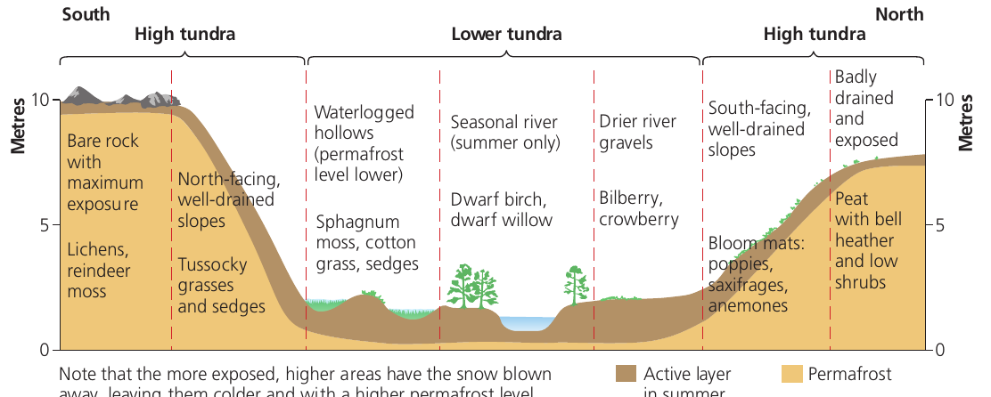
The distribution of vegetation varies across the tundra landscape. Higher, more exposed areas support only the hardiest species like bare rock with lichens and reindeer moss. Lower, better-drained slopes can support tussocky grasses and sedges. In waterlogged hollows, sphagnum moss, cotton grass and sedges dominate. On south-facing, well-drained slopes, dwarf birch and willow may grow alongside bilberry and crowberry. Areas with peat development can support bell heather and low shrubs.
Snow redistribution by wind creates variation in conditions across the landscape. More exposed, higher areas have snow blown away, leaving them colder with a higher permafrost level, whilst lower areas accumulate snow and have slightly warmer conditions.
Tundra soils
A distinctive soil type develops in tundra environments, shaped by the cold climate, limited vegetation, and presence of permafrost. These soils have unique characteristics that distinguish them from soils in warmer climates.
Main characteristics of tundra soils
The key features of tundra soils include:
- Lack of clearly differentiated soil horizons: Unlike soils in warmer regions, tundra soils do not develop distinct layers
- Thin surface organic layer: A shallow layer of peat or organic material forms at the surface, often very acidic
- Uniform blue-grey colour: The soil has a distinctive gleyed appearance
- Waterlogged in summer: Despite low precipitation, soils become saturated when the active layer thaws
- Gleyed profile: The soil shows characteristics of gleying - when waterlogging occurs, iron compounds are reduced to their ferrous form, giving a grey colour rather than the red-brown colour of ferric compounds
- Underlying permafrost: An impermeable layer of permanently frozen ground lies beneath the soil
Factors influencing tundra soil formation
Several factors explain why tundra soils have these distinctive characteristics:
Limited vegetation:
- Surface litter is restricted by the sparse plant cover
- Limited amounts of organic matter are available for incorporation into the soil
- Only a few soil organisms can survive in the harsh conditions
- The slow decay of vegetation and presence of few organisms means organic material accumulates at the surface rather than being mixed into the soil
Poor differentiation of horizons:
- With few soil organisms to act as mixing agents, the soil horizons remain poorly differentiated
- There is minimal biological activity to redistribute materials through the soil profile
- Limited leaching occurs except during spring meltwater periods
Frost action:
- Freezing of the soil in autumn causes it to be churned, with horizons becoming further distorted
- Frost-heave raises fragments (including stones) to the surface
- These processes contribute to the typical periglacial features seen in tundra landscapes
Waterlogging and gleying:
- During summer, the active layer thaws but water cannot drain through the impermeable permafrost below
- Low temperatures mean evaporation rates are minimal, so water accumulates
- Waterlogged, anaerobic (oxygen-poor) conditions lead to gleying
- In gleyed soils, the reduction of iron compounds creates the characteristic blue-grey colour
Tundra Soil Profile Structure
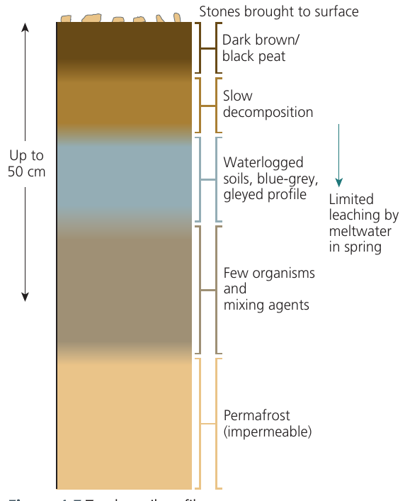
The tundra soil profile typically extends only to about 50 centimetres depth before reaching the permafrost layer. At the surface, stones brought to the surface by frost action are visible. Below this is a dark brown or black peat layer where organic material accumulates. Beneath the peat, a zone of slow decomposition leads into the waterlogged, blue-grey gleyed soils. Limited leaching may occur from spring meltwater, but there are few organisms and minimal mixing. The impermeable permafrost layer forms the base of the active soil profile.
Global distribution of cold environments
Cold environments cover significant portions of Earth's surface, though their extent has varied considerably over geological time. Understanding both current and past distribution patterns provides important context for studying these environments.
Current distribution
At present, cold environments are distributed across several regions:
Polar regions:
- Arctic areas within or near the Arctic Circle, including northern Alaska, Canada, Greenland, Scandinavia, and Russia
- Antarctica and surrounding Southern Ocean
Alpine areas:
- High-altitude mountain ranges on most continents, shown in purple on the distribution map
- Include the Himalaya, Alps, Rockies, Andes, and other major mountain systems
Tundra (periglacial) areas:
- Extensive zones in northern North America and Eurasia
- Fringes of Antarctica where ice-free conditions exist
- Currently cover about 8% of Earth's land area
The distribution map clearly shows that cold environments are concentrated in high latitudes (near the poles) and high altitudes (mountain regions). The largest continuous areas are in the Northern Hemisphere, particularly across northern Canada, Alaska, Scandinavia and Siberia.
Past distribution - the Last Glacial Maximum
Ice ages refer to periods when major cold phases (glacials) occurred and ice sheets covered large areas of the world, interspersed with warmer periods (interglacials). The last 2 million years (the Quaternary Period) contains the Pleistocene epoch lasting from about 1.8 million years to about 11,500 BP (before present). This was characterised by episodes of glaciation, with the last major glacial beginning around 120,000 BP and reaching the Last Glacial Maximum about 18,000 BP.
During the Pleistocene glaciations, particularly at the Last Glacial Maximum approximately 18,000 years ago, cold environments were far more extensive than today:
- About one-third of Earth's surface was covered by ice
- This compares to just one-tenth today
- Huge ice sheets covered large areas of North America and Europe
- Tundra environments extended across central North America and Europe, including the British Isles
- Sea ice extent was far greater in both Arctic and Antarctic regions
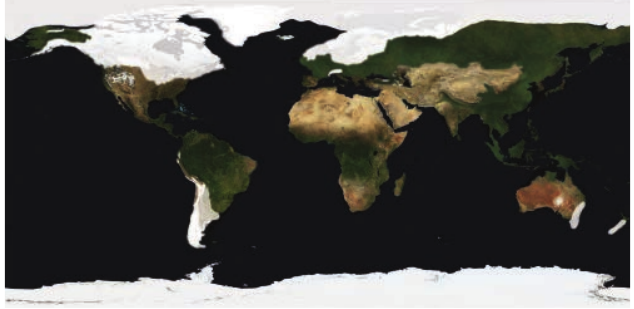
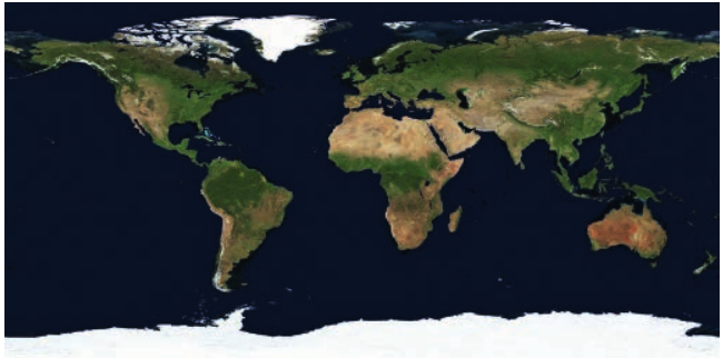
Dramatic Changes Since the Last Glacial Maximum
The images showing ice coverage from 18,000 years ago compared to January 2019 dramatically illustrate the retreat of ice cover since the Last Glacial Maximum. North America and northern Europe, which were covered by massive ice sheets, are now ice-free except in Greenland and the highest mountain areas. This demonstrates the dynamic nature of cold environments and their sensitivity to climate change over different timescales.
Throughout the Pleistocene glaciations between 1.6 million and about 12,000 years ago, glacials and interglacials alternated repeatedly. Cold environments expanded during glacial periods and contracted during warmer interglacial periods. There continues to be scientific debate about the exact number of glacial-interglacial cycles and the extent of ice coverage during various periods, but Figure 4.6 shows the current extent of cold environments globally.
The data in Table 4.1 shows that approximately 15.7 million km² of Earth's surface is currently covered by ice, with Antarctica alone accounting for 13.5 million km² and Greenland contributing 1.74 million km². The remaining ice is distributed across various regions including the Arctic, mountain ranges in Asia, Alaska, the Andes, Alps, and other locations, though in much smaller amounts.
Remember!
Key Points to Remember:
-
Cold environments are classified into four main types: polar (extreme cold at high latitudes), alpine (high-altitude mountains), periglacial (tundra with permafrost), and glacial (ice sheet-covered areas). Each has distinct characteristics based on latitude, altitude and physical conditions.
-
The climate of cold environments features mean temperatures below freezing for much of the year, very low precipitation (often under 300mm annually as snow), and strong winds with significant wind-chill effects. Polar regions are colder than tundra, with Antarctica being Earth's coldest location.
-
Cold climates result from low insolation (oblique sun angle at high latitudes means less heating), high albedo (ice reflects solar radiation), high-pressure systems (giving clear, dry conditions), and katabatic winds that intensify the cold.
-
Tundra vegetation is characterised by low productivity, limited species diversity, no full-grown trees, and hardy perennial plants including lichens, mosses, grasses and dwarf shrubs. Plants show remarkable adaptations like ground-hugging growth, shallow roots, and the ability to photosynthesise at very low temperatures.
-
Currently about 10% of Earth's land surface is ice-covered (15.7 million km²), dominated by Antarctica and Greenland. During the Last Glacial Maximum 18,000 years ago, approximately one-third of Earth was ice-covered, showing how cold environments have dramatically contracted since then.