Periglacial Features and Landforms (AQA A-Level Geography): Revision Notes
Periglacial Features and Landforms
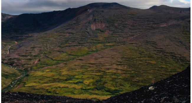
Introduction to periglacial environments
Periglacial environments are landscapes that experience very cold conditions with intense frost action and the development of permanently frozen ground called permafrost. Although these areas are not currently covered by glaciers, they are exposed to similar extreme cold conditions. Today, periglacial regions are found in tundra landscapes of northern Russia, Alaska and northern Canada, as well as high mountainous areas such as the European Alps. However, during past ice ages when ice sheets and glaciers were more extensive, many areas that are currently temperate experienced periglacial conditions.
Climate Characteristics of Periglacial Regions:
The climate in periglacial regions has several distinctive characteristics:
- Temperatures remain very cold throughout the year, with annual averages between -15°C and -1°C
- Annual rainfall is relatively low, typically ranging between 120 mm and 1,400 mm (excluding snowfall)
- Summers are short with temperatures occasionally rising above 15°C, but winters are harsh with temperatures in some areas dropping as low as -50°C
These extreme conditions drive unique processes that create distinctive landforms across periglacial landscapes.
Permafrost
Permafrost refers to ground that remains permanently frozen. In areas where temperatures below the ground surface stay below 0°C continuously for more than two years, permafrost will develop.
Currently, permafrost covers approximately 20-25% of the Earth's land surface. When water is present in the soil, it freezes and binds the mineral and organic particles together. The ground below this frozen layer that remains unfrozen is called talik.
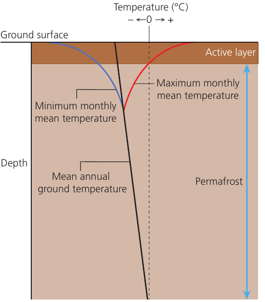
The diagram above shows how temperature changes with depth in permafrost. During summer, the surface warms and temperatures rise above freezing. This causes the surface layer to thaw from the top downwards, forming what is known as the active layer. The depth of this active layer varies based on local conditions, but it can extend up to 4 metres deep. As the ice in this layer melts during warmer periods, large volumes of water are released into the soil.
Types of permafrost
There are three main categories of permafrost, each occurring under different temperature conditions:
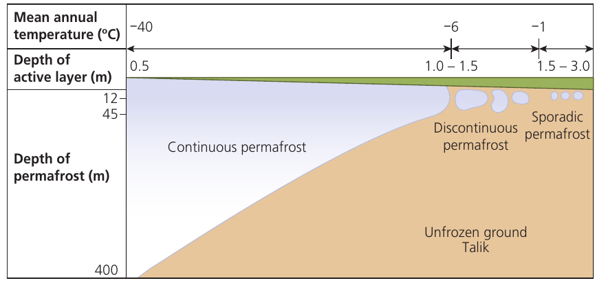
Continuous permafrost is found in the coldest regions where temperatures reach as low as -40°C. Here, the frozen ground extends deep into the surface layers. In Siberia today, permafrost is estimated to reach depths of over 1,500 metres. In the very coldest areas, there is hardly any melting of the uppermost layer even during summer. The active layer in these regions is typically only 0.5 metres deep, and permafrost can extend to depths of 400 metres or more.
Discontinuous permafrost occurs in regions that are slightly warmer, where the ground is not frozen to such great depths. The average frozen area extends 20-30 metres below the ground surface, although it can reach depths of 45 metres. In these areas, there are gaps in the permafrost beneath rivers, lakes and near the sea where the ground remains unfrozen. The active layer here ranges from 1.0 to 1.5 metres in depth, and permafrost extends 12-45 metres down.
Sporadic permafrost is found where mean annual temperatures are around or just below freezing point (approximately -1°C). In these locations, permafrost occurs only in isolated spots where the local climate is cold enough to prevent complete thawing of the soil during summer. The active layer can be 1.5-3.0 metres deep, but permafrost only exists in patches.
Quick Reference - Permafrost Types:
- Continuous: Coldest (-40°C), active layer 0.5 m, permafrost depth 400+ m
- Discontinuous: Warmer (-6°C), active layer 1.0-1.5 m, permafrost depth 12-45 m
- Sporadic: Warmest (-1°C), active layer 1.5-3.0 m, permafrost in patches only
Periglacial mass movement processes
Several processes cause material to move downslope in periglacial landscapes. These are sometimes called cryospheric slope processes because they are driven by freezing and thawing cycles.
Solifluction (also called gelifluction when related to freezing and thawing) occurs when summer temperatures rise high enough to melt the large amounts of ice held in the upper layers of the permafrost. Because the permanently frozen ground below acts as an impermeable layer, meltwater cannot drain away. Additionally, low temperatures mean little water is lost through evaporation. As a result, the surface layer becomes extremely wet and saturated. This excessive water reduces friction between soil particles. Even on slopes as gentle as 2°, this saturated layer becomes quite mobile and soil begins to flow downslope. While downslope movement of saturated soils can occur in many environments, when it is related to the freezing and thawing of the active layer, it is specifically referred to as gelifluction.
Some geographers also use a term for any flows of material within the still-frozen permafrost layer, called congelifluction.
Frost creep refers to the gradual downslope movement of individual soil particles. This occurs due to alternating freeze-thaw cycles within the active layer. The process relates to frost heave, which is explained in more detail in the next section.
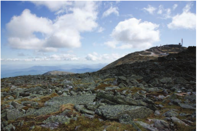
Rock falls result from freeze-thaw action, also known as frost shattering. This process involves the movement of large amounts of material and has already been described in detail in other sections. Scree slopes, which are accumulations of angular rocks called talus, develop at the base of steep slopes as frost shattering breaks rock apart. This is a common feature of periglacial landscapes. On relatively flat areas, extensive spreads of angular boulders are left behind. These are known as blockfield or Felsenmeer, which means "sea of rocks".
Periglacial landforms
A clear link exists between the landforms found in periglacial landscapes and the processes that create them. The main landforms and the processes that form them are explored in the following sections.
Patterned ground
The repeated cycles of freezing and thawing in the active layer produce a range of distinctive landforms collectively called patterned ground. While the formation of specific types of patterned ground can be quite complex, the main process involved is called frost heave.
The Frost Heave Process:
Frost heave is the key mechanism that creates patterned ground features:
- As the active layer starts to freeze, ice crystals begin to develop
- These ice crystals increase the volume of the soil, causing an upward expansion of the surface
- Frost heave is most significant in fine-grained material, and because it is uneven, it forms small domes on the surface
- Within fine-grained material there are stones which, due to their lower specific heat capacity, warm up and cool down faster than the surrounding finer material
- Cold penetrates from the surface and passes through the stones faster than through the surrounding material
- The soil immediately beneath a stone is likely to freeze and expand first, pushing the stone upwards until it reaches the surface

Depending on local conditions, a range of features can form. The table above summarises the key characteristics of the five main types of patterned ground: circles, nets, polygons, steps, and stripes.
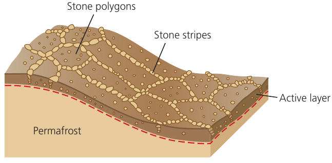
The diagram above shows how stone polygons and stone stripes form on the surface above the permafrost layer, with the active layer experiencing seasonal freezing and thawing.
Ice wedges and ice-wedge polygons
Ice wedges are another feature that creates a distinctive type of patterned ground called ice-wedge polygons. Ice wedges have several key characteristics:
- They are relatively narrow cracks or fissures in the upper layers of the ground that become filled with ice, sometimes extending below the level of the permafrost
- They have a milky appearance due to the presence of air bubbles trapped in the ice
- They begin as small cracks less than 5 cm across, but over hundreds of years can reach over 10 metres wide and extend many metres into the ground
In periglacial landscapes, these features result from ground contraction caused by extreme cold, generally occurring in areas of continuous permafrost.
Worked Example: Ice Wedge Formation Process
Understanding how ice wedges develop over time:
Step 1 - Winter Contraction: During winter, the freezing of the soil in the active layer causes the ground to contract, creating an initial crack in the surface.
Step 2 - Summer Infilling: In the following summer, the initial small crack becomes filled with meltwater, called an ice vein when it freezes.
Step 3 - Repeated Cycles: This process repeats through the cycle of winter and summer, with each cycle widening and deepening the crack until it eventually forms a large ice wedge over hundreds or thousands of years.
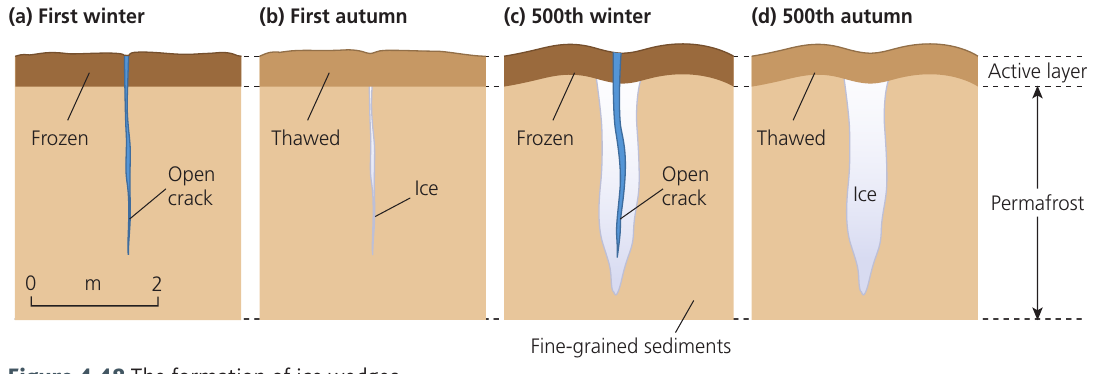
The way the ground contracts creates a pattern of cracks on the surface. When viewed from above, these have a similar shape to stone polygons. They are therefore known as ice-wedge polygons. These features are often larger than stone polygons and are generally 15-30 metres in diameter, though they can reach 100 metres across. They are also generally only found on flat or very gently sloping surfaces.
If the climate warms enough for all the ice to melt, it may be replaced by fine-grained sediment that fills the void, forming an ice-wedge cast. These fossil features provide evidence of past periglacial conditions.
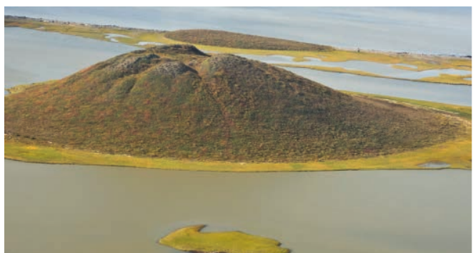
Pingos
Pingo is an Inuit term for a dome-shaped, ice-cored mound of earth found in periglacial landscapes. Pingos vary in size and age. They can be just a few metres in height and diameter, but the oldest pingos, found in areas like the MacKenzie Delta in northern Canada, are believed to be about 1,000 years old and stand over 50 metres high and over 300 metres in diameter. Some have been recorded as exceeding 600 metres across. Research suggests that they may grow by 2 to 3 centimetres per year.
The ice core results from a slow injection of pressurised water into the dome. There are two types of pingo based on the different origins of this water, and the processes underlying their formation are complex.
Two Types of Pingos:
- Closed system pingos: Form through hydrostatic pressure from water trapped beneath former lake beds (found in continuous permafrost)
- Open system pingos: Form through hydraulic pressure from groundwater flowing under artesian pressure (found in discontinuous permafrost)
Closed system pingos (MacKenzie Delta type)
Closed system pingos are famously found in the MacKenzie Delta area of the Northern Territories, Canada. They generally form in areas of continuous permafrost and develop beneath former lake beds. The growth of the ice core is hydrostatic, meaning it results from pressure differences in the water system.
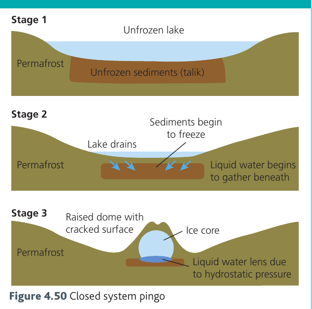
Worked Example: Closed System Pingo Formation
The formation process occurs in three stages:
Stage 1 - Initial Lake Conditions: A deep lake (over 2 metres deep) may remain unfrozen during winter. The permafrost layer at the lakebed is insulated from the cold by the water above it. This creates an area of unfrozen waterlogged ground sandwiched between the lake surface and the underlying permafrost layer, called a talik.
Stage 2 - Lake Drainage and Freezing: If the lake drains or becomes shallower, the lakebed is no longer insulated from the cold. The waterlogged bed begins to freeze from above. As the newly freezing water expands, it gathers together and pushes downward, creating a lens of liquid water beneath the freezing layer.
Stage 3 - Ice Core Formation: Due to localised differences in pressure between the lake bed, the freezing lakebed, and the underlying permafrost, this liquid water is forced together. It forms an ice lens that expands, pushing the lakebed sediments upward and creating the characteristic raised dome shape with a cracked surface. The ice lens continues to grow as long as there is still unfrozen ground in the lakebed acting as a source of pressurised water to add to the ice core.
Open system pingos (East Greenland type)
Open system pingos are common in Greenland and Alaska and are generally found in areas of discontinuous permafrost, particularly in valley bottoms. The growth of the ice core is hydraulic, meaning it is driven by water flowing under artesian pressure.
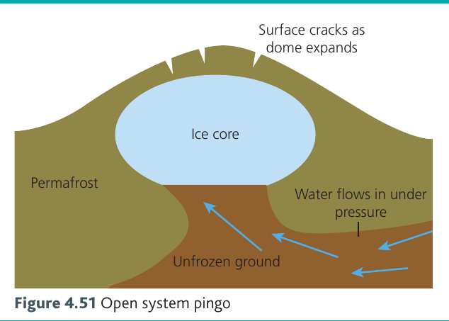
The formation process works differently from closed system pingos:
- Water is able to seep into the upper layers of the ground and flows from higher surrounding areas under artesian pressure
- Water accumulates in flat, low-lying areas where the upper layers of permafrost or soil and frozen ground trap the water beneath them
- As the freezing ice core expands, it domes the overlying layers upward into the classic pingo shape
- Surface cracks appear on the dome as it expands
- The pingo can continue to grow as pressurised water keeps flowing in from the surrounding higher ground
Collapsed pingos
As a pingo grows, increasing cracks and instability develop on the steep sides, which may eventually cause the ice core to be exposed. As ice melts, the pingo collapses. When the ice core has completely melted, all that remains is a doughnut-shaped mound, possibly containing a small lake in the centre. Some present-day temperate regions contain fossil pingos, providing evidence of their colder past climates.
Solifluction features
Where solifluction (or gelifluction) occurs on slopes, distinctive features develop. The exact form depends on the slope gradient.
Solifluction sheets form on slopes of around 1-20°. These have a smooth surface and can extend over 100 metres across a slope.
Solifluction lobes develop where slopes have a steeper gradient of 10-20°. These features have a tongue-like appearance that extends downslope. They can be up to 50 metres in width and 5 metres in height. Depending on local subsurface conditions and slope processes, solifluction features can also form terraces.
Terracettes
Terracettes are small periglacial features often referred to as "sheep tracks" because they resemble small narrow pathways running horizontally along the side of a slope. They are narrow steps with a tread surface usually only tens of centimetres wide that runs generally parallel to the contours of the slope. They are bounded by a low steep border (called a riser) that is steeper than the slope itself.
Some geographers believe terracettes are associated with the processes of frost action and creep described earlier. However, others suggest they may be formed by the trampling of animals traversing steep slopes. Many researchers have not found any in landscapes that would be inaccessible to animals.
Thermokarst
Thermokarst refers to depressions in the ground surface resulting from ice melting within the permafrost. This melting causes localised subsidence, giving a ground surface appearance similar to limestone karst geology, where hollows, depressions and collapsed structures result from erosion and weathering of the limestone bedrock. However, thermokarst only results from temperature changes rather than erosion and weathering. These features occur where human activity inadvertently warms the surface layers of the permafrost.
Process, time and landforms in periglacial landscapes
It is important to view each unique periglacial landscape as an assemblage of features and landforms that combine in that place to give it its own characteristic appearance. To fully understand why a landscape looks as it does today, it is crucial to look beyond the processes currently happening and think about how different processes may have shaped its features through time.
Understanding Landscape Development Rates:
The rate of development of different landscapes in cold environments varies considerably. Some landscapes are shaped rapidly by the almost constant action of erosion, weathering and deposition processes. For example:
- Warm-based glaciers moving rapidly will erode and deposit material far more quickly than landscapes shaped by cold-based glaciers
- Many weathering processes operate at a far faster rate in more temperate cold environments than in the very coldest regions
- Cycles of freezing and thawing may happen dozens of times during a Scottish winter on an almost daily basis
- In the coldest parts of the polar regions, the freezing and thawing cycle may only operate over a timescale of millennia
Therefore, time has an extremely important role in controlling the pace of the processes that shape cold environments, even at the local level. To fully understand the features of a characteristic periglacial landscape, it must be viewed in its entirety as an assemblage of a range of landforms.
Ice ages have come and gone on Earth throughout the Quaternary period, which spans the last 2.58 million years. During this time there have been many glacial and interglacial fluctuations, initially operating on a 41,000-year cycle and more recently on about a 100,000-year cycle. In fact, there have been eight glacials in the last 740,000 years. During each of these periods, ice advanced from the polar regions and, in the northern hemisphere, each glacial advance slowly altered the landscape shaped by the previous ice advance. So the glaciated landscape we see today, in the current interglacial period, is the result of cycles of processes acting through millennia.
The Land Systems Approach:
As periglacial landscapes often border current glacial landscapes, they too are ever-changing environments. In the past, during glacials, landscapes that are currently periglacial may have been glacial and covered by ice. Therefore, the characteristic landscape we see today is not just the result of recent periglacial processes, but a combination of short-term and long-term cycles of glacial and periglacial activity.
This land systems approach to studying landscapes provides a much broader geographical context to the study of glacial landscapes, taking into account not just current processes but also cycles of processes that have occurred over a very much longer timescale.
Key Points to Remember:
-
Periglacial environments are cold regions with intense frost action and permafrost, but not currently covered by glaciers. They are found today in tundra regions and high mountains.
-
Permafrost is ground that remains frozen for at least two years, with an active layer on top that thaws seasonally. There are three types: continuous (coldest), discontinuous, and sporadic (warmest).
-
Mass movement processes in periglacial areas include solifluction (saturated soil flow), frost creep (gradual particle movement), and frost shattering (creating blockfields).
-
Patterned ground forms through frost heave creating distinctive surface patterns (circles, polygons, steps, stripes). Ice wedges form through repeated thermal contraction and create polygonal patterns.
-
Pingos are ice-cored mounds formed by two mechanisms: closed system pingos (hydrostatic pressure from lake drainage) and open system pingos (hydraulic pressure from groundwater flow).
-
Current periglacial landscapes reflect both recent processes and long-term cycles of glacial and interglacial activity over millennia. Understanding these timescales is essential to interpreting the features we see today.