Impacts of Climate Change and Tropical Revolving Storms (AQA A-Level Geography): Revision Notes
Impacts of Climate Change and Tropical Revolving Storms
Understanding tropical revolving storms
Tropical revolving storms are powerful, rotating weather systems that develop over warm tropical oceans. These storms are known by different names depending on where they occur in the world, but they all share similar characteristics and formation processes. Understanding where they form, how strong they can become, and how climate change is affecting them is essential for predicting their future behaviour and preparing communities.
Tropical revolving storms represent some of nature's most powerful and destructive weather phenomena. While they go by different names around the world, they all form through the same fundamental processes and pose similar threats to coastal communities. Modern science has revealed that climate change is significantly altering these storms' characteristics, making it more important than ever to understand their behaviour.
Distribution of tropical revolving storms
These powerful weather systems develop in specific tropical regions between 5° and 20° latitude on both sides of the Equator. Once they form, they typically move westward and reach their most destructive force in particular areas.
Regional names and locations
Different parts of the world use different names for these storms:
- Hurricanes form in the Caribbean Sea and Gulf of Mexico region, accounting for 11% of all tropical revolving storms globally
- Hurricanes also develop on the western side of Central America in the eastern Pacific Ocean (17% of all storms)
- Cyclones occur in the Arabian Sea and Bay of Bengal area (8% of all storms)
- Typhoons develop off southeast Asia, representing the largest proportion at one-third of all storms occurring worldwide each year
- Cyclones also form near Madagascar in the southeast African region (11% of storms)
- Willy-willies is the local name given to storms in the north-western and north-eastern regions of Australia (20% of global storms)
Seasonal patterns
Each region experiences these storms during specific seasons. For example, hurricanes in the Caribbean typically occur from August to October, while typhoons in East Asia happen between May and December. These seasonal patterns are linked to when ocean temperatures are warmest in each region.
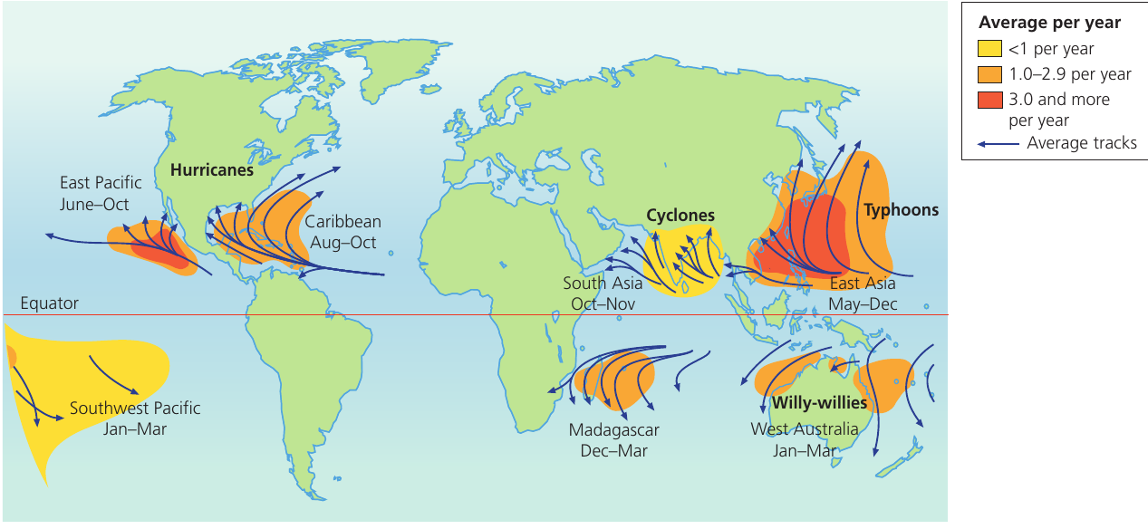
Quick Reference - Storm Names by Region:
Remember the global distribution using these regional terms:
- Caribbean & Gulf of Mexico: Hurricanes
- Indian Ocean (Arabian Sea & Bay of Bengal): Cyclones
- Western Pacific (Southeast Asia): Typhoons
- Australia: Willy-willies (informal local name)
All these storms share the same basic structure and formation process, but cultural and geographic differences led to different naming conventions in each region.
Magnitude and classification
Understanding the strength of tropical revolving storms is crucial for warning systems and emergency preparations.
The Saffir-Simpson scale
Tropical revolving storms are measured using the Saffir-Simpson scale, which classifies storms into five categories based solely on wind speed. This scale helps authorities and communities understand the potential danger of an approaching storm.
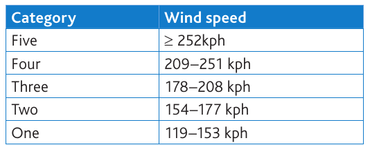
The five categories range from:
- Category One (least intense): wind speeds of 119-153 kph
- Category Two: wind speeds of 154-177 kph
- Category Three: wind speeds of 178-208 kph
- Category Four: wind speeds of 209-251 kph
- Category Five (most intense): wind speeds of 252 kph or greater
Limitations of the scale
There is ongoing debate about whether the Saffir-Simpson scale should be revised or replaced. The scale only measures wind damage, but research shows that nearly 90% of deaths from tropical storms in the United States result from water-related hazards rather than wind. These water hazards include storm surges, extreme rainfall, and inland flooding, which the current scale does not directly measure.
Critical Limitation of the Saffir-Simpson Scale:
While the Saffir-Simpson scale is widely used for storm classification, it has a major flaw: it only measures wind speed. However, research demonstrates that 90% of deaths from tropical storms result from water-related hazards (storm surges, flooding, and rainfall) rather than wind damage. This means the scale may not accurately reflect a storm's true danger to human life, as a slower-moving Category 1 hurricane with extreme rainfall can be deadlier than a fast-moving Category 4 storm.
Definition: Tropical revolving storm
A powerful rotating weather system that develops over warm tropical oceans, characterised by extremely strong winds, heavy rainfall, and low atmospheric pressure. These storms typically last 7-14 days and develop when ocean temperatures exceed 26.5°C.
The impacts of climate change on tropical revolving storms
Climate change is altering the behaviour and characteristics of tropical revolving storms in significant ways. Research has provided important insights into how these changes are occurring and what we might expect in the future.
Evidence of changes since 1970
In 2005, researchers published findings examining changes in tropical cyclone patterns since 1970, when reliable satellite data became available. Their analysis revealed important trends:
- Overall, the total number of cyclones globally has decreased
- However, in the North Atlantic Ocean specifically, there has been a significant increase in both the number and proportion of very strong cyclones
- The intensity of storms in certain regions has increased notably
Why is climate change affecting storms?
The increase in ocean temperatures caused by climate change creates conditions that lead to more intense storms. Here's how this process works:
Increased ocean warming leads to:
- Higher air temperatures above the warmer water surfaces
- Enhanced uplift (rising of warm, moist air) which lowers atmospheric pressure at the surface
- Greater oceanic evaporation, which increases the amount of water vapour in the atmosphere
These factors then work together in a feedback process. When parcels of very moist air rise and cool at higher altitudes, they release enormous amounts of latent heat through condensation. This further strengthens the uplift process, creating more powerful storm systems.
Understanding the Climate Change-Storm Intensity Connection:
Warmer oceans act like fuel for tropical storms. As climate change raises ocean temperatures:
- More water evaporates from the ocean surface (increased evaporation)
- Warm, moist air rises more vigorously (enhanced uplift)
- More water vapour condenses at altitude, releasing latent heat
- This heat release strengthens the storm's circulation further
This creates a positive feedback loop where warmer oceans lead to more intense storms. Think of it like adding more fuel to a fire - the warmer the ocean, the more energy available to power the storm.
Predictions for 2100
Scientists have used climate models to predict how tropical storms might change by the year 2100. While predictions vary between different models, the general consensus suggests:
- An increase of 2-11% in the average intensity of storms
- A decrease of between 6% and 34% in the total number of tropical storms
- A substantial increase in the frequency of the most intense storms (Categories 4 and 5)
This means that while we might see fewer storms overall, the ones that do form are likely to be significantly more powerful and destructive.
Key Climate Change Prediction:
By 2100, we face a concerning paradox: fewer but fiercer storms. While total storm numbers may decrease by 6-34%, storm intensity could increase by 2-11%, with a dramatic rise in Category 4 and 5 events. This means communities need to prepare for less frequent but far more devastating storm impacts.
Slow-moving storms
A study published in 2017 identified another concerning trend: tropical storms are slowing down. As polar regions warm due to climate change, there is less difference in atmospheric pressure between the poles and the tropics. This reduced pressure gradient means the winds that normally push storms along are becoming weaker, causing storms to move more slowly across the landscape.
Why slower storms are more dangerous:
Slow-moving storms can produce significantly more rainfall because they remain over the same area for longer periods. Research suggests there could be a 20% increase in precipitation falling within 100 km of a storm's centre. This enhanced rainfall is further amplified by the greater amount of water vapour carried in the warmer atmosphere. Additionally, slower storms increase wind damage simply because strong winds affect areas for longer periods. They also create larger walls of seawater (storm surges) in front of them, increasing the potential for devastating coastal flooding.
The Slow-Moving Storm Phenomenon:
Climate change is causing atmospheric pressure differences between polar and tropical regions to decrease. This weakens the jet stream and other atmospheric winds that normally push tropical storms along their paths. As a result:
- Storms move more slowly across land and sea
- They drop more rainfall in concentrated areas (up to 20% more)
- Wind damage persists for longer periods
- Storm surges have more time to build up
Hurricane Harvey (2017) and Hurricane Florence (2018) both demonstrated this dangerous trend, remaining nearly stationary and causing catastrophic flooding.
Case study: Hurricane Florence (2018)
Hurricane Florence provides a clear example of how climate change is influencing storm impacts. This Category 1 hurricane moved very slowly after making landfall in North Carolina, USA, in September 2018. The storm remained nearly stationary for several days, causing widespread and prolonged flooding.
Worked Example: Hurricane Florence (2018) - A Climate Change-Influenced Storm
Hurricane Florence demonstrated how climate change amplifies storm impacts through slow movement and enhanced rainfall:
Storm Characteristics:
- Classification: Category 1 (relatively weak on the Saffir-Simpson scale)
- Movement: Nearly stationary for several days after landfall
- Location: North Carolina, USA, September 2018
Key Impacts:
- Rainfall: 760mm over just 5 days (exceptionally high)
- Storm surge: 1.7 metres in coastal areas
- Deaths: At least 55 people
- Economic costs: $17.9 billion in damages
- Flooding extent: Extensive inland flooding far from the coast
Climate Change Connection: Research demonstrated that the exceptional rainfall was made approximately 50% worse by human-influenced climate warming. Without climate change, the storm would have dropped significantly less rain, reducing the catastrophic flooding impact.
Key Lesson: Even a Category 1 storm can cause massive destruction when climate change factors (slow movement, enhanced rainfall) amplify its impacts. This challenges the traditional focus on wind speed as the primary danger metric.
The impacts of tropical revolving storms
The damage and disruption caused by tropical revolving storms depend on multiple interconnected factors. Understanding these helps explain why some storms cause much more damage than others, even when they have similar wind speeds.
Factors affecting vulnerability
Several factors determine how vulnerable a location is to storm damage:
- Storm intensity (Categories 1-5 on the Saffir-Simpson scale)
- Speed of movement - slower storms cause more damage as they affect areas for longer
- Distance from the sea - areas further inland typically experience less severe impacts
- Physical geography - the width of coastal plains, presence of river deltas, and location of mountain ranges all influence impact severity
- Community preparations - whether adequate warning systems, evacuation plans, and protective infrastructure exist
- Warning and response - how quickly authorities issue warnings and how effectively communities respond
Understanding Vulnerability is Key:
A storm's category alone doesn't determine its total impact. Vulnerability depends on a complex interaction of factors. For example:
- A Category 3 storm hitting a well-prepared coastal city with evacuation plans may cause fewer deaths than a Category 1 storm hitting an unprepared river delta community
- Slow-moving storms cause more damage than fast-moving ones, regardless of wind speed
- Physical geography matters: low-lying river deltas and wide coastal plains face greater flood risks
This is why emergency planning must consider all vulnerability factors, not just storm intensity.
Primary impacts
Tropical revolving storms create three main types of direct impact, each capable of causing severe damage and loss of life.
Winds
The powerful winds associated with these storms can often exceed 150 km/hr, with Category 5 events experiencing winds over 250 km/hr. These extreme winds cause several types of damage:
- Structural damage to buildings, with winds strong enough to cause buildings to collapse entirely
- Destruction of roads, bridges, and other infrastructure
- Bringing down electricity transmission lines, leaving areas without power for extended periods
- Devastating agricultural areas by destroying crops and farm buildings
- Creating dangerous flying debris that poses a serious threat to people and property
The massive amounts of debris flung about by the winds create additional hazards, damaging anything in their path.
Heavy rainfall
Tropical storms bring intense rainfall that commonly ranges from 200mm to 300mm, though higher amounts frequently occur. This extreme precipitation causes multiple problems:
- Severe flooding across wide areas, both near the coast and inland
- Landslides on steep terrain where heavy rain saturates the soil
- Mudslides in areas with loose soil or deforested slopes
In coastal areas with high relief (elevation), rainfall amounts can increase dramatically to over 500mm per day. This is particularly dangerous as it combines with other storm impacts to create compound disasters.
Storm surges
Storm surges occur when strong winds push ocean water towards the coast, causing sea levels to rise dramatically as a result of lower atmospheric pressure in the storm. These surges create walls of water that surge inland.
Storm surges have a particularly devastating effect on low-lying coastal areas. River deltas are especially vulnerable because flooding can extend far inland along river channels. During major storm events, agricultural areas near the coast can suffer damage for extended periods as the soil becomes contaminated by sea water, making it unsuitable for farming until the salt can be washed away or broken down naturally.
Definition: Storm surge
A temporary rise in sea level caused by a storm's winds pushing water towards the coast and lower atmospheric pressure allowing the ocean surface to rise. Storm surges can extend flooding many kilometres inland, especially in low-lying coastal areas. They represent one of the most deadly aspects of tropical storms, accounting for a large proportion of storm-related deaths.
The Three Primary Impacts - Remember the "Three Ws":
-
Winds - Direct damage from extreme wind speeds (150-250+ km/hr)
- Structural damage to buildings
- Infrastructure destruction
- Flying debris hazards
-
Water (Rainfall) - Flooding and landslides from extreme precipitation (200-500+ mm)
- Inland flooding
- Landslides on steep terrain
- Prolonged waterlogging
-
Waves (Storm Surge) - Coastal flooding from wind-driven ocean water
- Low-lying coastal area inundation
- Saltwater contamination of agricultural land
- Extension of flooding along river channels
Remember: 90% of deaths come from water impacts (rainfall flooding and storm surges), not from wind damage!
Responses to storm hazards
Modern technology and scientific understanding have greatly improved our ability to predict and prepare for tropical storms.
Preparedness
Advances in data collection and analysis mean that tropical storm prediction has become increasingly sophisticated and accurate. This improved forecasting gives communities more time to prepare and potentially save lives.
Modern forecasting systems:
Weather bureaus, such as the National Hurricane Centre in Florida, USA, use multiple data sources to track and predict storms:
- Weather satellites provide real-time views of storm location, track, size, and strength from space
- Specialised aircraft fly directly into hurricanes to investigate their structure and gather detailed measurements
- Weather balloons collect atmospheric data at different heights
- Powerful supercomputers analyse all this data from different sources to predict storm paths and intensity changes
These forecasting systems allow authorities to issue timely warnings to communities in the path of approaching storms, giving people time to evacuate to safer areas or secure their property. The more accurate the predictions, the more effective the preparations can be.
Modern Storm Tracking Technology:
The combination of multiple technologies has revolutionised tropical storm prediction:
Space-based monitoring:
- Weather satellites provide continuous surveillance of storm development and movement
- Enable tracking of storms from formation through to dissipation
Direct measurement:
- Hurricane hunter aircraft fly through storms collecting real-time data
- Weather balloons measure atmospheric conditions at various altitudes
Data analysis:
- Supercomputers process vast amounts of data from all sources
- Generate predictions of storm tracks and intensity changes
- Allow forecasters to issue warnings days in advance
This multi-layered approach has dramatically improved prediction accuracy, giving communities precious time to prepare and evacuate, ultimately saving countless lives.
Key Points to Remember:
-
Tropical revolving storms form between 5° and 20° latitude and have different regional names (hurricanes, cyclones, typhoons, willy-willies) depending on location
-
Climate change is making storms more intense but potentially less frequent overall, with predictions suggesting a 2-11% increase in intensity but a 6-34% decrease in total numbers by 2100
-
Storms are becoming slower-moving due to reduced atmospheric pressure differences, leading to 20% more rainfall and longer periods of damaging winds in affected areas
-
The three main impacts are winds (causing structural damage), heavy rainfall (causing flooding and landslides), and storm surges (causing coastal flooding) - with 90% of deaths resulting from water rather than wind
-
Modern forecasting using satellites, aircraft, and supercomputers has greatly improved prediction accuracy, allowing communities more time to prepare and potentially save lives
-
The Saffir-Simpson scale classifies storms by wind speed (Category 1: 119-153 kph to Category 5: 252+ kph) but has limitations as it doesn't account for water-related hazards
-
Hurricane Florence (2018) demonstrated climate change impacts: as a Category 1 storm, it caused $17.9 billion in damages and 55 deaths due to slow movement and 50% enhanced rainfall from climate warming