Impacts of Seismic Events (AQA A-Level Geography): Revision Notes
Impacts of Seismic Events
Earthquakes themselves rarely kill people who are in open areas. The real danger comes from collapsing buildings, falling debris, tsunamis, and landslides triggered by the shaking. Some impacts occur immediately during and after the earthquake (primary effects), while others develop over time and depend on the affected area's ability to recover (secondary effects).
Measuring earthquake intensity
Understanding the severity of an earthquake requires measuring not just its magnitude but also its observable effects on people, buildings, and the landscape.
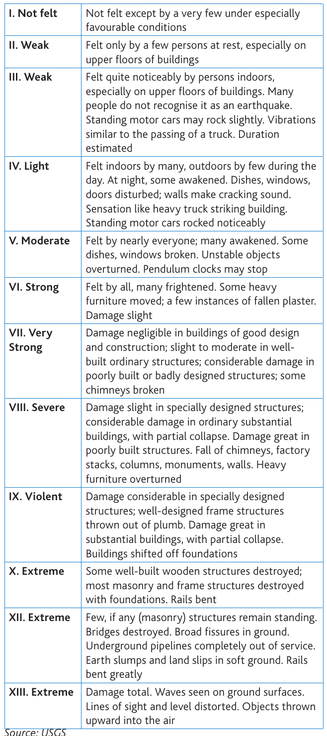
The Modified Mercalli scale provides a way to assess earthquake intensity based on observed damage and human experience rather than instrumental measurements. This scale ranges from level I (not felt except by very few people) to level XIII (extreme, causing total damage with visible waves on the ground surface).
The scale is particularly useful because it accounts for local conditions. For example, buildings on soft sediments may experience more severe shaking than those on bedrock, even at the same distance from the epicentre. Seismic records using instruments only date back to 1848, so for earlier earthquakes we must rely on historical accounts and the Modified Mercalli scale to understand their impacts.
Primary effects
Primary effects are the immediate consequences of ground shaking during an earthquake. These occur as seismic waves travel from the earthquake's focus through the Earth's crust.
Ground shaking
Primary hazard: The initial impact of an earthquake caused by shock waves travelling through the crust from the focus to the surface and then radiating outwards.
When an earthquake strikes, shock waves move up from the underground focus to the surface, then spread outwards in all directions. The intensity of shaking depends on several factors:
- The earthquake's magnitude (strength)
- Depth of the focus (shallow earthquakes cause more surface damage)
- Distance from the epicentre
- Local geological conditions (soft sediments amplify shaking)
Case Study: Mexico City earthquake (1985)
Although the earthquake occurred far from the city, the shock waves were amplified several times by the ancient lake sediments beneath Mexico City. Different districts experienced varying levels of shaking depending on their underlying soil foundations, with ground motion in the city measuring five times greater than in outlying areas.
This demonstrates how local geology can dramatically affect the severity of ground shaking, even at considerable distances from the epicentre.
Ground rupture
Ground rupture: The visible breaking and displacement of the Earth's surface, usually along the line of a fault.
Ground rupture creates cracks and displacement at the Earth's surface, typically following existing fault lines. This poses major risks to large engineered structures such as:
- Dams (which could fail catastrophically)
- Bridges (which may collapse if supports are displaced)
- Nuclear power stations (which require stable foundations)
Even relatively small amounts of ground displacement can render these critical structures unsafe or inoperative.
Secondary effects
Secondary effects develop as consequences of the primary shaking. These can be equally or even more devastating than the earthquake itself.
Soil liquefaction
Soil liquefaction: When violently shaken, soils with a high water content lose their mechanical strength and start to behave like a fluid.
During intense shaking, waterlogged soils can temporarily lose their solid properties and flow like liquid. This causes buildings and infrastructure to sink, tilt, or collapse even if they were well-constructed.
Case Study: Palu, Indonesia (2018)
The Indonesia earthquake caused major soil liquefaction within and around the city of Palu. This led mudflows that submerged many buildings, and in one tragic case, an entire village was swallowed.
The city is built on lake sediments with high water content, making it particularly vulnerable to this hazard. This case demonstrates how geological conditions can amplify earthquake impacts through secondary effects.
Land slides and avalanches
Earthquake shaking can trigger slope failure, particularly in mountainous regions. The ground vibrations reduce the stability of slopes, causing them to collapse.
Case Study: Gorkha earthquake, Nepal (2015)
Following this earthquake, scientists from NASA documented 4,312 landslides occurring between the earthquake in April and the onset of monsoon rains in June. Most landslides were relatively small rockfalls and debris avalanches, but some were large enough to block entire valleys.
In the Langtang valley, the village of Langtang was almost completely buried by landslide debris. This demonstrates how mountainous terrain significantly increases vulnerability to earthquake-triggered landslides.
Tsunamis
Tsunami: A dangerous series of waves that can be triggered by any event that disrupts the sea floor.
Tsunamis are giant sea waves generated by shallow-focus underwater earthquakes. They can also be triggered by underwater volcanic eruptions, debris slides, or large landslides entering the sea. These waves have distinctive characteristics:
- Very long wavelength (sometimes exceeding 100 km)
- Low wave height in the open ocean (under one metre)
- Extremely high speed (over 700 km per hour in deep water)
- Increase dramatically in height when reaching shallow coastal waters
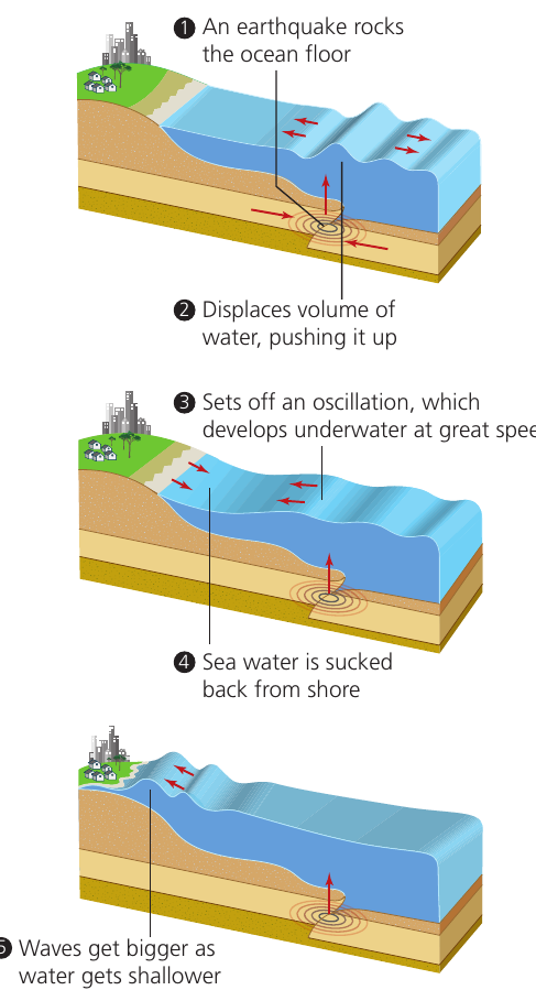
When tsunamis approach land, they slow down but grow significantly in height. The first sign of an approaching tsunami is often a wave trough, causing the sea to recede dramatically from the shore (called drawdown). This is followed by the tsunami waves themselves, which can reach heights exceeding 25 metres.
Tsunami impacts depend on:
- The length of the event at its source
- Whether warnings could be issued
- Coastal geography (both offshore and onshore features)
- Coastal land use and population density
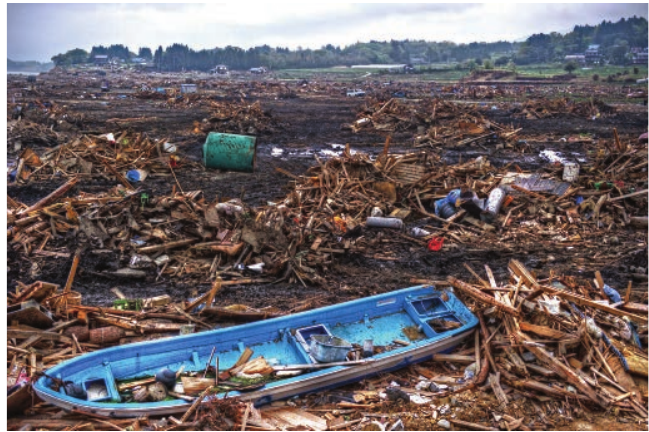
The waves wash boats and wooden coastal structures far inland. The backwash then carries this debris back out to sea. Both the water itself and the debris it carries are hazardous. Buildings, roads, bridges, harbour structures, trees and even soil can be washed away. Tsunamis typically have an impact zone extending at least 500-600 metres inland, depending on coastal geography.
Distribution of tsunamis: Around 90% of all tsunamis occur within the Pacific Basin, associated with tectonic activity around its edges. Most are generated at convergent plate boundaries where subduction is occurring, particularly on the western side of the Pacific (25% of all events).
Fires
Fires frequently break out after earthquakes due to:
- Broken gas pipes leaking flammable gas
- Collapsed electricity transmission systems creating sparks
- Damaged infrastructure preventing fire-fighting efforts
These fires can spread rapidly, particularly if water mains are also damaged, preventing effective fire-fighting responses.
Case study examples
Boxing Day tsunami, east Indian Ocean (2004)
On 26th December 2004, a powerful magnitude 9.0 earthquake struck 25 km below the Indian Ocean floor off northwest Sumatra. This was one of the largest earthquakes ever recorded.
Impact Analysis: Boxing Day Tsunami
Human toll:
- Killed an estimated 300,000 people in bordering countries
- Devastated hundreds of communities
Infrastructure damage:
- Caused extensive damage to coastal communications, particularly bridges and railway lines
- Left local economies unable to support affected populations
Economic cost:
- The insurance industry estimated total costs at less than $5 billion
- The relatively low insurance cost reflects that many affected areas had low levels of insurance coverage
Positive outcome:
- A tsunami warning system was established among countries bordering the Indian Ocean
Tohoku earthquake and tsunami, Japan (2011)
In March 2011, a magnitude 9.0 earthquake occurred 70 km offshore on the Pacific coast of the Tohoku region of Japan. This was the most powerful earthquake ever recorded in Japan, with estimates suggesting it moved the main island of Honshu 2.4 metres eastward.
Impact Analysis: Tohoku Earthquake and Tsunami
Tsunami characteristics:
- Tsunamis reached heights exceeding 40 metres
- Waves penetrated over 10 km inland in some locations
Human toll:
- Nearly 16,000 deaths
- Over 6,000 people injured
- 2,500 people missing
- Over 300,000 people displaced from their homes
Infrastructure damage:
- 127,000 buildings destroyed
- 277,000 buildings 'half collapsed'
- 750,000 buildings partially damaged
- Fukushima nuclear power plant seriously affected, resulting in evacuation of residents within 20 km
Economic cost:
- Total insurance costs exceeded $30 billion
- Economic cost to Japan estimated at $235 billion
Secondary impacts: Tsunami waves travelled right across the Pacific Ocean to North and South America. In Chile, the tsunami created waves 2 metres high.
Sulawesi earthquake and tsunami, Indonesia (2018)
In September 2018, following a series of small tremors, a shallow magnitude 7.5 earthquake struck the island of Sulawesi in Indonesia. The epicentre was 77 km from the city of Palu.
Case Study: Sulawesi Tsunami - Unique Characteristics
Unusual features:
- Generated a localised tsunami with an estimated height of 4-7 metres
- The tsunami struck Palu shortly after the earthquake
- Caused by a mostly horizontal crustal movement (most large tsunamis are caused by vertical movement)
- Triggered underwater rockslides, which generated the tsunami
- Located at the end of a narrow bay, the tsunami's force became more concentrated
- Reached heights of nearly six metres at Palu
Human impact: The waves particularly affected a festival taking place on Palu's main beach at the time, killing or injuring many participants. This demonstrates how timing can significantly affect casualty figures from natural hazards.
Responses to seismic hazards
Preparedness
Earthquakes can strike with no warning, making them particularly challenging hazards. Therefore, people living in earthquake-prone regions must adopt a constant state of readiness. The simple mantra 'Drop, cover, and hold on' should be taught to children from a young age and practised regularly.
Within the home:
- Secure heavy items such as televisions, refrigerators and bookcases
- Store breakable items at low levels
- Create a family communication plan (for example, a WhatsApp group)
- Establish an emergency meeting place
Emergency supplies:
- Maintain an emergency supply kit lasting a few days
- Include tinned food, water, clothing, bedding
- Add a first-aid kit, toilet paper, torch, fire extinguisher and whistle
- Store important documents and a radio
Building standards:
- Homes should be constructed to be structurally sound
- This is most important in countries where building codes are lax or non-existent
- Where financially possible, people should take out specialised earthquake insurance
Earthquake prediction challenges
Predicting earthquakes remains extremely difficult. Scientists can identify high-risk regions through plate tectonics theory, but predicting exactly when and where an earthquake will strike is currently beyond our capabilities.
Prediction attempts: Some efforts have focused on monitoring:
- Groundwater levels
- Release of radon gas from rocks
- Unusual animal behaviour
- Movement along fault lines (such as the San Andreas Fault)
Despite these monitoring efforts, predicting an earthquake even a few hours before it occurs remains unrealistic for the foreseeable future.
Fault line studies: Close examination of fault lines can sometimes indicate where along the fault the next earthquake might occur. Scientists study the pattern of previous events along the fault to identify sections that are 'overdue' for movement. However, this provides only a general indication of location, not timing.
Key Points to Remember:
-
Primary effects occur immediately during ground shaking, including ground rupture and building collapse, while secondary effects like tsunamis, landslides, soil liquefaction and fires develop afterwards.
-
The Modified Mercalli scale (I-XIII) measures earthquake intensity based on observed damage and effects rather than instrumental readings, making it useful for historical earthquakes.
-
Tsunamis are characterised by very long wavelengths and low heights in open ocean, but slow down and increase dramatically in height when reaching shallow coastal waters, often exceeding 25 metres.
-
Soil liquefaction occurs when waterlogged soils lose strength during shaking and behave like fluid, causing buildings to sink or collapse even if well-constructed.
-
Preparedness is essential because earthquakes cannot be predicted - people in at-risk areas should practise 'drop, cover, and hold on', secure heavy objects, maintain emergency supplies, and ensure buildings meet earthquake-resistant standards.