Responses to Volcanic Hazards (AQA A-Level Geography): Revision Notes
Responses to Volcanic Hazards
Understanding how to respond to volcanic hazards is essential for protecting communities living near active volcanoes. While we cannot prevent eruptions, various strategies can help reduce their devastating impacts. These responses fall into four main categories: preparedness, mitigation, prevention, and adaptation.
The effectiveness of volcanic hazard response depends on combining multiple strategies. No single approach can fully protect communities, but together these methods significantly reduce risk and save lives.
Preparedness
Preparedness involves predicting when a volcanic eruption might occur and taking action before disaster strikes. Early warning can save thousands of lives by allowing people to evacuate danger zones in time.
Historical context
The importance of preparedness becomes clear when we look at historic disasters.
Historical Lesson: The Destruction of Pompeii
In AD 79, the Roman cities of Pompeii and Herculaneum were completely destroyed by Mount Vesuvius. A fast-moving current of hot gas and volcanic matter (pyroclastic flow) and heavy ash fall killed thousands of people. Despite being part of an advanced civilisation, the inhabitants had no understanding of the danger they faced.
This tragedy demonstrates what happens when communities lack volcanic hazard awareness and monitoring systems. Even today, people sometimes underestimate volcanic risks. In 2002, many residents were caught out by the eruption of Mount Nyiragongo in the Democratic Republic of the Congo.
Modern prediction capabilities
Scientists can now predict volcanic eruptions with increasing accuracy. Early prediction means authorities can move people away from high-risk areas, protecting lives. This represents a major advance in volcanic hazard management.
Monitoring techniques
Volcanoes are continuously monitored using various methods:
- Local observatories: Ground-based stations track volcanic activity
- Satellite monitoring: Space-based systems detect changes from above
- Seismic networks: Arrays of instruments detect earthquake activity
Modern volcanic monitoring uses multiple complementary systems. By combining data from different sources, scientists can identify patterns and warning signs more reliably than any single monitoring method could achieve.
Warning signs of eruption
Scientists look for several key indicators that a volcano may be about to erupt:
- Increased gas emissions: Higher levels of gases escape from the volcano, particularly sulphur dioxide and carbon dioxide
- Rising lava lakes: The level of molten rock in volcanic craters increases
- Ground deformation: The land around the volcano bulges upwards due to pressure from below
- Earthquake swarms: An increasing number of small earthquakes occur as magma rises through the crust
These warning signs rarely appear in isolation. Volcanologists look for patterns across multiple indicators. A combination of increasing seismic activity, rising gas emissions, and ground deformation provides much stronger evidence of an impending eruption than any single sign.
Studying eruption history
Examining a volcano's past behaviour helps scientists predict future activity. Different types of volcanic activity leave distinctive deposits around volcanoes. For example, ash layers, lahars (volcanic mudflows), and pyroclastic flows create characteristic patterns. If a particular type of hazard occurred before, we can expect it to happen again. This historical analysis also helps identify which areas face the greatest risk and how frequently eruptions occur.
Mitigation
Mitigation refers to actions taken to reduce or eliminate the long-term risks posed by volcanoes. Several strategies can lessen the impact of volcanic hazards.
Risk assessments
Risk Assessment: A systematic evaluation of volcanic hazards that helps governments identify danger zones and establish alert level systems.
Risk assessments form the foundation of effective volcanic hazard management. They identify who is at risk, where the greatest dangers lie, and what types of hazards pose the most serious threats.
Countries at risk from volcanic activity, such as the Philippines, conduct detailed risk assessments. These assessments produce maps showing different levels of hazard and create warning systems to alert the public when danger increases. Figure 5.18 demonstrates a risk assessment for the area around Mount Rainier in the Cascade Range, USA. This is particularly important as approximately 3.5 million people live and work near this volcano.
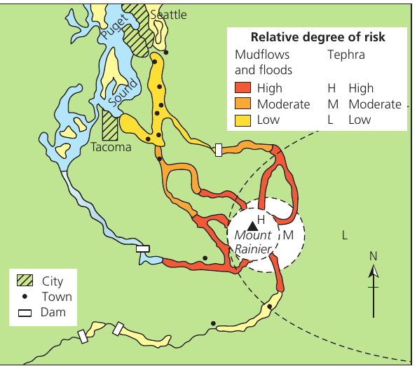
The map shows different zones of risk from mudflows, floods, and tephra (volcanic ash). High-risk zones appear in red, moderate risk in orange, and low risk in yellow. Notice how the danger extends down river valleys away from the volcano itself, highlighting the threat from lahars that can travel many kilometres from the source.
Physical interventions during eruptions
When a volcano erupts, some immediate actions can help reduce impacts:
Lava diversion:
Once viscous (thick, slow-moving) lava begins flowing, it may be possible to divert it away from populated areas. On Mount Etna in Sicily, authorities have dug trenches, placed blocks in the lava stream, and used explosives. These methods have successfully slowed lava flows and, in some instances, diverted them away from buildings.
Cooling with Water: Heimaey, Iceland (1973)
In 1973, residents of Heimaey in Iceland took a creative approach to a lava flow threatening their vital fishing port. They poured seawater onto the advancing lava front, causing it to solidify before it could cut off their access to the open sea.
This innovative intervention demonstrated that human action can sometimes influence the direction and progress of lava flows, though success depends on the specific characteristics of the eruption and local conditions.
Protective barriers:
In parts of the Hawaiian Islands, barriers have been constructed across valleys to protect settlements from lava flows and lahars. These physical structures can deflect or slow down volcanic hazards.
Evacuation strategies
The most common method of protecting people from volcanic hazards is evacuation. When risk becomes too high, authorities move vulnerable populations to safer locations.
Evacuations present challenges. If carried out carelessly, future evacuations become more difficult to manage because people may not trust warnings. Building and maintaining public trust in warning systems is essential for effective volcanic hazard management.
Evacuations have been successfully conducted several times in the Philippines, including before the Pinatubo eruption in 1991 and the Mayon eruption in 2018.
Sometimes permanent evacuation becomes necessary. Following the eruption of the Soufrière Hills volcano on Montserrat in 1995, two-thirds of the Caribbean island was designated an exclusion zone where people cannot live. This represents a drastic but sometimes unavoidable response to extreme volcanic risk.
Prevention
Critical Understanding: Prevention is Impossible
There is no way to prevent a volcanic eruption from occurring. The immense geological forces involved are far beyond human control.
However, disasters can be prevented or significantly reduced through mitigation strategies, particularly evacuation conducted well in advance of an eruption. While we cannot stop volcanoes from erupting, we can prevent eruptions from becoming catastrophes.
Adaptation
Perhaps the most effective long-term response involves moving away from areas surrounding active volcanoes. In Montserrat, this relocation proved to be permanent for many residents.
Adaptation can also mean changing how people live near volcanoes. After the eruption of Nyiragongo in 2002, farmers in the Democratic Republic of the Congo returned to their fields and adapted their agricultural practices. They shifted from growing maize to cash crops such as cabbage and bananas. This change proved economically beneficial - in some cases, farmers' income doubled compared to before the eruption.
Adaptation strategies recognise that volcanic risk cannot always be eliminated. Instead, communities find ways to live with volcanic hazards while minimising their exposure to danger. This approach acknowledges both the threats and benefits (such as fertile volcanic soils) that volcanoes bring.
Case study: Mount Mayon, Philippines (2018)
Background and location
Mount Mayon rises to 2,462 metres above sea level, making it the most active volcano in the Philippines. This composite volcano (a steep-sided volcano built from layers of lava and ash) has a documented eruption history dating back to 1616. The volcano sits within an area of 250 square kilometres, and although it's located in a national park, it's surrounded by the city of Legaspi and eight other towns. The region has a population of approximately 200,000 people. Mount Mayon is also a popular tourist destination, renowned for its symmetrical conical shape.
The volcano's activity is regularly monitored by PHIVOLCS, a Philippine government department dedicated to providing information on the activities of volcanoes, earthquakes, and tsunamis. Mount Mayon's position results from the subduction of the Philippine Sea Plate underneath the Sunda Plate, forming part of the Pacific Ring of Fire.

Risk and vulnerability
Several factors make communities around Mount Mayon particularly vulnerable:
Ash hazards:
Large ash emissions from Mount Mayon generally settle within a few kilometres of the volcano. This ash affects Legaspi, the capital of Albay province, which has a population of almost 200,000 people. Legaspi serves as a major centre for tourism, education, health services, commerce, and transportation. The ash, composed of fine grains of rock, settles on roofs and often causes buildings to collapse under the weight.
Lahar risk:
Ash emissions also settle in the gullies on the volcano's flanks. The area receives high rainfall (3,432 millimetres annually), with January and February being the wettest months. This heavy rain creates conditions for lahars to form. These volcanic mudflows destroy everything in their path. In the short term, ash emissions destroy local agriculture, but over the long term, volcanic ash can enrich the soil.
Pyroclastic flows:
Nuées ardentes (a type of pyroclastic flow - a fast-moving, extremely hot mixture of gas and volcanic matter) concentrate in the gullies. These extremely dangerous flows destroy everything they encounter.
Lava flows:
These directly damage or destroy local agriculture and infrastructure.
Mount Mayon presents multiple, overlapping hazards. Communities face threats from ash fall, lahars, pyroclastic flows, and lava flows simultaneously. This complexity makes risk management particularly challenging, as different hazards require different response strategies.
The 2018 event
Historical data shows that Mount Mayon's eruption events follow a cycle. Eruptions typically begin with ash emissions and basaltic eruptions, followed by longer-term andesitic lava flows from the central crater. These lava flows travel far down the mountain's flanks. Pyroclastic flows and mudflows commonly sweep down the approximately 40 ravines that radiate from the summit, often devastating populated lowland areas.
The 2018 Eruption Event
Mount Mayon has erupted regularly throughout the first 20 years of this century, but the most significant eruption occurred in 2018. The event demonstrated the importance of monitoring and rapid response systems in protecting vulnerable populations living near active volcanoes.
The 2018 eruption showcased how effective preparedness and mitigation strategies can prevent volcanic activity from becoming a major disaster. PHIVOLCS monitoring detected early warning signs, allowing authorities to evacuate thousands of people before the eruption intensified.
Key Points to Remember:
-
Preparedness saves lives: Early prediction through monitoring allows evacuation before eruptions, preventing casualties
-
Multiple monitoring methods work together: Scientists use seismic networks, gas sensors, ground deformation measurements, and satellite imagery to detect warning signs
-
Mitigation takes many forms: Risk assessments, physical barriers, lava diversion, and evacuation planning all help reduce volcanic impacts
-
Adaptation may be necessary: Sometimes the best response is permanent relocation away from volcanic areas, though communities can also adapt by changing agricultural practices or settlement patterns
-
Prevention is impossible: Volcanic eruptions cannot be stopped, but their impacts can be significantly reduced through proper planning and response strategies