Storm Hazards (Typhoons, Hurricanes) (AQA A-Level Geography): Revision Notes
Storm Hazards (Typhoons, Hurricanes)
Introduction
Tropical revolving storms are among the most powerful and destructive natural hazards on Earth. These intense weather systems go by different names depending on where they occur - hurricanes, typhoons, cyclones, or willy-willies - but they all share the same basic characteristics and formation processes. Understanding how these storms develop, where they strike, and their potential impacts is essential for geography students studying atmospheric hazards.
Nature of tropical revolving storms
Tropical revolving storms are intense low-pressure weather systems that develop in tropical regions. These violent storms typically measure between 200 and 700 kilometres in diameter, making them enormous atmospheric phenomena that can affect vast areas.
Studies of atmospheric pressure patterns reveal a broad zone of low pressure that circles the globe on either side of the Equator. Within this zone, winds converge from different directions. On the northern side, north-east trade winds blow in from the north-east, whilst on the southern side, south-east trade winds blow from the south-east.
Critical Conditions for Storm Formation
The formation of these powerful storms requires several specific conditions to come together simultaneously. All of these conditions must be present for a tropical revolving storm to develop.
The formation of these powerful storms requires several specific conditions to come together:
-
Warm ocean water: The sea surface temperature must be at least 27°C, with this warmth extending to a depth of 70 metres or more. This warm tropical ocean provides the energy source for the storm.
-
Distance from the Equator: Storms must form at least 5° latitude away from the Equator. This distance is necessary for the Coriolis force to have sufficient effect on the developing system.
-
Rising air and low pressure: Within the low-pressure zone, air heats up as it passes over the warm ocean. This heated air rises in discrete parcels, creating thundery showers that may group together into larger thunderstorm systems. As these storms intensify, low pressure develops at the surface.
-
The Coriolis effect: When the storm system is far enough from the Equator, the Coriolis force acts upon the converging winds. This force causes the incoming air to spiral inward and accelerate around the central depression.
-
Condensation and latent heat: As the air rises, it cools and expands. This cooling leads to condensation of moisture vapour in the air. When water vapour condenses, it releases latent heat, which acts as feedback to fuel further uplift. This creates a self-sustaining cycle that powers the storm's development.
Energy Source and Storm Lifespan
The storm continues to exist as long as there is a supply of latent heat and moisture to provide energy, and low frictional drag on the ocean surface allows the system to maintain its intensity. Once the storm moves over land or reaches colder waters towards the poles, its energy source is cut off and it begins to decline.
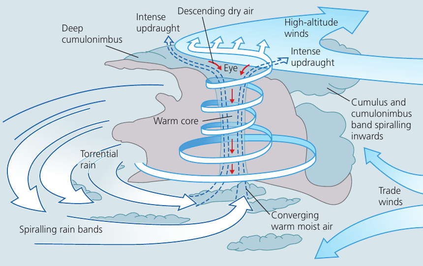
Structure of a tropical revolving storm
A mature tropical revolving storm has a distinctive structure with several key features:
The eye: At the centre of the storm sits a remarkable feature - the eye. This is an area approximately 10-15 kilometres in diameter where conditions are surprisingly calm. Within the eye, there are clear skies, higher temperatures, and descending air. It provides a brief respite before the second half of the storm arrives.
The Most Intense Zone
Surrounding the calm eye, wind speeds can exceed 300 kilometres per hour. This is where the most intense conditions occur - a stark contrast to the calm conditions just a few kilometres away in the eye itself.
The warm core: The storm system has a warm core running through its centre, created by the latent heat released during condensation.
Rain bands: Spiralling outwards from the centre are bands of cumulus and cumulonimbus clouds that produce torrential rainfall. These rain bands spiral inwards towards the storm's centre.
Air circulation: At the surface, warm moist air converges and spirals inward. This air rises rapidly through intense updrafts. At high altitude, winds blow outward from the centre, allowing the system to maintain its circulation.
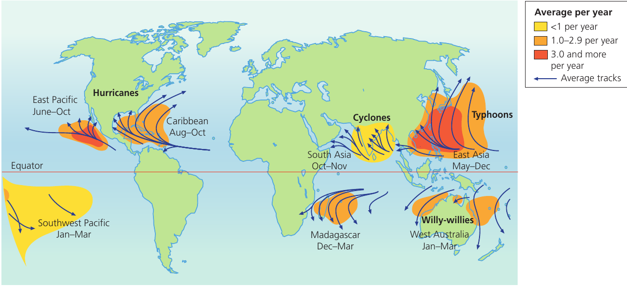
Distribution of tropical revolving storms
Tropical revolving storms occur in specific regions around the world, always between 5° and 20° degrees north and south of the Equator. Once formed, they tend to move in a westward direction and are at their most destructive in these zones.
Regional Names and Locations
These storms have different names depending on where they occur in the world:
-
Hurricanes: Found in the Caribbean Sea and Gulf of Mexico area (accounting for 11 per cent of all tropical revolving storms globally). Peak season is August to October. They also occur in the East Pacific from June to October (17 per cent of global storms).
-
Typhoons: These occur off south-east Asia and are known by this name in the East Asia region from May to December. This is the major area for such storms, with one-third of all storms every year occurring here.
-
Cyclones: Found in the Arabian Sea and Bay of Bengal area (8 per cent of global storms). Peak season is October to November, with another period in South Asia.
-
Willy-willies: The distinctive name given to these storms in north-western and north-eastern Australia (20 per cent of global storms). In West Australia, the peak season is January to March.
Other affected regions include areas off Madagascar in south-east Africa (11 per cent of storms, December to March) and the Southwest Pacific (January to March).
The average lifespan of a tropical storm is between 7 and 14 days, although scientists believe these storms may be lasting longer as a result of climate change. Each year, approximately 80-100 such storms develop around the world, with around 80 per cent of these developing into fully-fledged tropical revolving storms.
Magnitude and the Saffir-Simpson scale
Tropical revolving storms are measured using the Saffir-Simpson scale. This is a five-point classification system based solely upon wind speed.
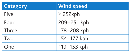
The categories range from:
- Category One: Wind speeds of 119-153 kph (the weakest category)
- Category Two: 154-177 kph
- Category Three: 178-208 kph
- Category Four: 209-251 kph
- Category Five: 252 kph or greater (the most intense category)
The Wind Speed Paradox
There is an important debate about whether this scale remains the most useful way to classify these storms. Recent research has shown that nearly 90 per cent of tropical storm deaths in the United States were not caused by wind damage, but rather by water-related hazards including storm surges, extreme rainfall, and inland flooding.
This finding suggests that classifying storms solely by wind speed may not accurately reflect their true danger to human life.
Key Definition: Storm Surge
A storm surge is a rapid rise in sea level in which water is piled up against a coastline to a level far in excess of normal conditions at high tide. Storm surges are produced during the passage of a tropical storm. Wind-driven waves pile up water against a coastline, whilst simultaneously the ocean surface heaves upwards as a result of the much lower air pressure associated with the storm. This combination can raise sea levels by several metres, causing devastating coastal flooding.
Storm surges represent one of the most deadly aspects of tropical revolving storms, often causing more casualties than the high winds themselves.
The impacts of climate change on tropical revolving storms
Climate change is having measurable effects on tropical revolving storm patterns. Research published in the scientific journal Science in 2005 examined changes in tropical cyclone number, duration, and intensity since 1970 - the period when satellite data became available for reliable monitoring.
The findings revealed a complex picture:
-
Global decrease: The overall number of cyclones across the world had decreased during this period.
-
Regional variation: Despite the global decrease, there was a substantial increase in both the number and proportion of very strong cyclones that occurred in the North Atlantic Ocean.
Understanding the Changes: Ocean Temperature Effects
Scientists propose that the increase in ocean temperatures provides one explanation for these changes. Higher ocean temperatures lead to:
- Increased air temperature above the warmer water
- Enhanced uplift of air and local lowering of atmospheric pressure
- Greater oceanic evaporation
- A corresponding increase in atmospheric water vapour content
These conditions create a more favourable environment for the development of intense storms in certain regions, even as overall global numbers decline.
This suggests that whilst we may see fewer storms in total, the ones that do form may be more likely to reach the highest intensity categories, making them potentially more dangerous and destructive.
Key Points to Remember
-
Tropical revolving storms are intense low-pressure systems (200-700 km diameter) that require warm ocean water (27°C+), distance from the Equator (5°+ latitude for Coriolis effect), and rising moist air to form.
-
These storms have different regional names: hurricanes (Caribbean/Americas), typhoons (East Asia), cyclones (Indian Ocean region), and willy-willies (Australia).
-
The storm's structure features a calm eye (10-15 km wide) surrounded by extreme winds (300+ km/hour), spiralling rain bands, and torrential rainfall.
-
The Saffir-Simpson scale classifies storms into five categories based on wind speed, but 90% of deaths actually result from water hazards (storm surge, flooding) rather than wind damage.
-
Climate change is creating fewer storms globally but increasing the proportion of very strong cyclones, particularly in the North Atlantic, due to rising ocean temperatures that enhance uplift and increase atmospheric moisture.