Hot Desert Systems (AQA A-Level Geography): Revision Notes
Arid Landscape Development
Introduction to desert landscape formation
Desert landscapes are shaped by the combined action of wind and water, despite the limited rainfall. The unique climate of hot deserts means that both erosional and depositional processes work differently compared to more humid environments. Understanding how these processes interact with local geology helps explain the spectacular variety of landforms found in arid regions worldwide.
The episodic role of water in hot deserts
Patterns of rainfall in arid regions
Rainfall in hot desert regions is highly irregular and unpredictable. Subtropical deserts like the Sahara experience prolonged dry periods punctuated by occasional intense storms. These areas typically receive very low annual rainfall (around 25 mm per year on average), though some locations in high plateaux may receive up to 100 mm annually.
The variability is extreme - some desert areas can go between two and five years without receiving more than 0.1 mm of rain in any 24-hour period. However, when rain does fall, it can be remarkably intense. Individual storms can deliver two to three times the annual average in just a few hours. For example, some slopes in Algeria have recorded intensities of 8.7 mm in 3 minutes and 46 mm in just over an hour.
This episodic nature of rainfall is particularly pronounced in the Sahara during summer months when the West African Monsoon occasionally pushes moist air northward into the desert. Disruption of the subtropical high-pressure belt can also create low-pressure areas, bringing rainfall to the southern edges of the Sahara.
Despite being arid environments, water plays a crucial role in shaping desert landscapes through rare but powerful erosional and depositional events.
Sheet flooding
When intense rainfall occurs, the impermeability of many desert surfaces combined with the sheer volume and speed of rainfall can lead to widespread surface water flow. This process, known as sheet flooding or overland flow, begins when rainwater dislodges and moves loose material across the surface (called sheet wash or sheet erosion).
As the volume of water increases, this overland flow intensifies and can rapidly develop into extensive but relatively shallow floods. These floods can remove large volumes of material through sheet erosion, creating erosional features whilst simultaneously contributing to depositional features downstream.
Channel flash flooding
Wadis (also called arroyos in the Americas) are steep-sided, narrow valleys that remain dry most of the time but can carry powerful flash floods during storms.
If overland flow becomes concentrated and funnelled into steep-sided narrow valleys, channel flash flooding occurs. These sudden torrents can move significant volumes of sediment and possess enormous erosive power. The concentration of water in a narrow valley creates a deep, fast-flowing torrent capable of substantial erosion and sediment transport, forming significant depositional features when the flow eventually subsides.
Aeolian landforms created by wind
Introduction to wind processes
Wind plays a fundamental role in shaping desert landscapes through erosion, transport and deposition. These aeolian processes (wind-related processes) create distinctive landforms. Although similar processes occur in most desert environments, the resulting landscapes are unique to each location, reflecting how erosional, transport and depositional processes interact with local geology and climate.
Ventifacts
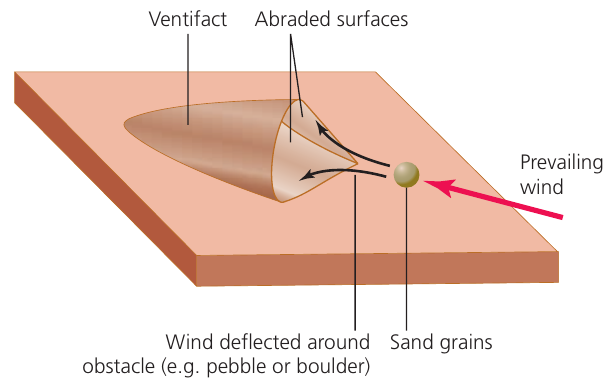
Ventifacts are rocks lying on the desert surface that have been abraded and sculpted by wind-blown sediment. This process is similar to a sand-blasting effect, where sand or finer silt and clay-sized particles carried by the wind gradually wear away exposed rock surfaces.
Ventifacts range in size from small pebbles (as little as a centimetre) to huge boulders many metres in diameter. They are characterised by smooth and/or flattened sides (called facets) and sharp edges or ridges. Many exhibit different 'faceted-types' with varying numbers of flattened sides and sharp edges.
The precise formation mechanism is not completely understood. Some ventifacts have multiple smooth facets, which may have formed because:
- The rock changed position over time, exposing different sides to the prevailing wind
- The prevailing wind direction changed over time
- There are areas with seasonal reversals of wind direction (different prevailing winds in summer and winter)
Yardangs
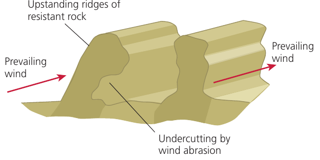
A yardang is a streamlined parallel ridge of rock, often compared to an upturned boat keel. These features are aligned in the direction of prevailing winds, with neighbouring yardangs separated by wind-scoured grooves or troughs.
The streamlined shape - featuring a rounded upwind face and a long tapering section downstream - suggests that aeolian erosional processes are the dominant formation mechanisms. Wind abrasion is crucial in shaping and defining the ridge, whilst also eroding material from the intervening troughs.
However, the formation of larger yardangs likely took millions of years, so other processes may have contributed. Where yardangs exist in areas of horizontal geological bedding, deflation, sporadic fluvial erosion, weathering and mass movement may also play a role.
Yardangs vary considerably in size. Ridges can range from a few centimetres high and several metres long up to so-called mega-yardangs measuring tens of metres high and extending for many kilometres. Several regions of the central Saharan desert contain large numbers of these massive features, including areas west of the Tibesti Mountains in northern Chad. These mega features are so large and occur in such high concentrations that they are easily visible in remotely sensed satellite imagery.
Zeugen
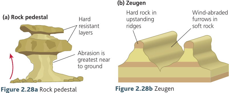
Zeugen is a collective term referring to features such as rock pillars, rock pedestals and rock mushrooms that display considerable undercutting. This range of names reflects different characteristics, but all form where less-resistant rock underlies a layer of more resistant geology at the surface.
As wind transports large amounts of sediment (mainly within two metres of the surface), abrasion becomes the main agent of erosion. Rock pedestals and mushrooms are relatively small features with dimensions of several metres. However, where features become elongated in the direction of the prevailing wind, they can develop dimensions similar to yardangs.
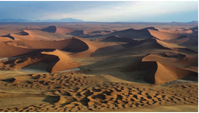
Sand dunes
Conditions required for dune formation
Sand dunes are the principal depositional landforms in hot desert environments. However, certain conditions must be met for dunes to form:
Dune Formation Requirements:
- A ready supply of sand
- Prevailing winds strong enough to transport sediment, but not so strong that they remove more material than is deposited
- Steady winds from one dominant direction
- An obstacle (such as vegetation or rocks) to trap the sediment and encourage deposition
Where large sand supplies exist and extensive dune development occurs, the landscape is called an erg. The specific size and shape of dunes varies widely depending on:
- The direction and strength of prevailing winds
- The supply of sediment available
- The morphology of the landscape where dunes form
- The presence of any other winds
Barchans
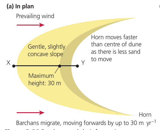
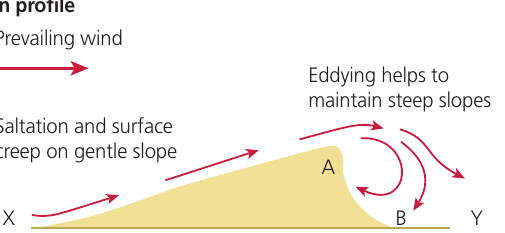
Barchans are crescent-shaped sand dunes with a gently sloping convex windward side. Two distinctive horns or wings extend laterally, curving in a downwind direction. The leeward, downwind face (or slip face) of the dune forms a steeper concave slope.
Barchans only develop where winds arrive almost exclusively from one direction. As material is moved up the windward slope by saltation and creep processes, it then slides, falls and flows down the leeward side. This movement causes the entire dune to migrate downwind across the desert landscape. The leeward slope remains steep due to eddying of wind as it descends down the dune.
Worked Example: Barchan Dune Migration
The height of barchans ranges from a few millimetres to giant dunes between 500 m and 1,000 m tall. Barchans can migrate forward by up to 30 metres per year. The horns advance more rapidly than the centre of the dune because there is less sand mass to move in these areas.
Individual barchans do exist, but they more commonly occur in groups or linear formations to create constantly shifting 'sand-seas'.
Seif dunes
Seif dunes derive their name from an Arabic term meaning 'sword-dune'. These knife-edged ridges of sand, also called longitudinal dunes, form long parallel ridges separated by wind-scoured depressions.
Groups or chains of seif dunes can extend over 100 km and reach heights exceeding 200 m. The tops and sides of such dunes are often serrated due to local wind action and eddying processes.
Other dune classifications
Contemporary classifications recognise several other dune types:
-
Transverse dunes: Resembling large-scale sand ripples, these feature large ridges of sand with a steep downwind face. They form in large groups or 'fields' of dunes in areas with an abundant, constant sand supply. They can result from barchan dunes coalescing if their supply of sand increases significantly.
-
Parabolic (or blowout) dunes: A horseshoe-shaped dune where the open end faces upwind. These are relatively stable features that develop where vegetation has colonised the dune. They occur where there is a constant sand supply, often in coastal locations.
-
Star dunes: These have variable slip face directions as they occur in areas with an abundant sand supply but variable wind directions. They are often massive and permanent dome-like features extending over hundreds of kilometres and reaching hundreds of metres high, creating a draa landscape.
Landforms created by water
Introduction to fluvial processes
Despite episodic and low-intensity rainfall being the norm, occasional sudden isolated heavy downpours can significantly affect desert landscape development. In mountainous upland areas and plateaux, water primarily acts as an agent of erosion. In lowland regions, depositional features tend to dominate.
Wadis
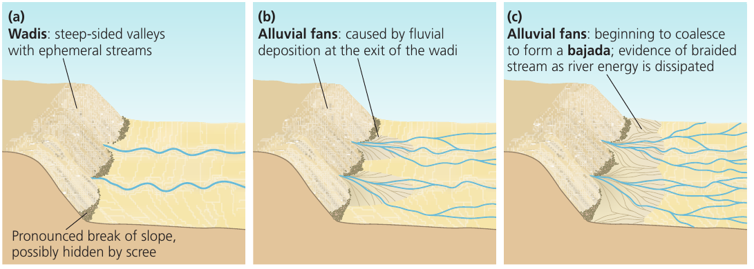
Wadis are steep-sided, wide-bottomed, gorge-like valleys carved by fluvial erosion in arid and semi-arid regions. Since wadis are rarely filled with water, the valley walls are typically steep and often covered with thick layers of weathered material, with sediment accumulation on the valley floor.
These valleys are either permanently dry (due to climate change and the drying up of former rivers) or only occasionally occupied by ephemeral streams (temporary water flows following sudden storms). They can range from small channels a few metres wide to complex channel systems extending over 100 km in length.
When ephemeral channels do appear on the valley floor, they are often braided. This occurs because the large amounts of previously deposited material force the stream to find multiple pathways through the sediment. The stream pattern changes following each flash flood event.
Bajadas and pediments
Where a distinct break in gradient occurs as highland regions meet more gently sloping lowland areas or depressions, a pediment develops. These are gently sloping areas (less than 7° gradient) of bare rock and debris.
Pediments form through various processes including fluvial erosion and the deposition of material washed down from uplands. The material is deposited as the capacity (total volume of sediment) and competence (size of particles) of the water suddenly decreases due to the abrupt change in slope angle.
If wadis or valleys containing ephemeral or perennial streams run down from uplands, depositional material may accumulate on these pediments. This occurs because water rapidly loses energy when meeting the much gentler slopes. The deposited load creates alluvial fans - distributaries that spread out from wadi exits onto the pediment.
The deposited material is graded, meaning the coarsest material remains at the upstream end of the alluvial fan whilst the smallest material is carried to the downstream end. Alluvial fans can extend from a few metres to several kilometres from the mouth of the wadi.
In areas where a linear mountain range has several parallel wadis in close proximity, alluvial fans from adjacent wadis may coalesce, forming a bajada that covers or extends just beyond the pediment.
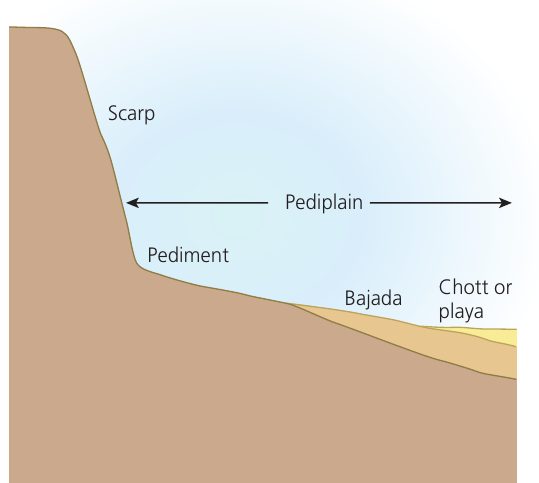
Playas
Permanent standing bodies of water or lakes are rare in hot desert regions due to the intermittent nature of rainfall. Where ephemeral streams flow into inland basins or depressions, temporary salt lakes (also called chotts or playas) form. Following rare rainfall periods, water quickly evaporates due to intense heat, leaving a dry lakebed behind.
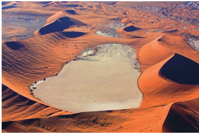
These lakebeds consist of salt deposits (evaporites) that were carried in by streams and precipitated during evaporation. Sodium chloride (NaCl) is the most common precipitate, giving the dry lakebed a colour resembling a beach (the possible origin of the name 'playa', which means beach in Spanish). Other salts commonly found in these crusts include calcium sulphate (gypsum), sodium sulphate, magnesium sulphate, and potassium and magnesium chlorides.
One notable example is Chott el Djerid in southern Tunisia, which occupies an intermontane basin over 100 km wide consisting almost entirely of bare salt flats.
Inselbergs, mesas and buttes
Mesas and buttes form in regions where the bedrock is sedimentary with horizontal bedding planes and a resistant cap rock. Fluvial erosion creates these isolated features.
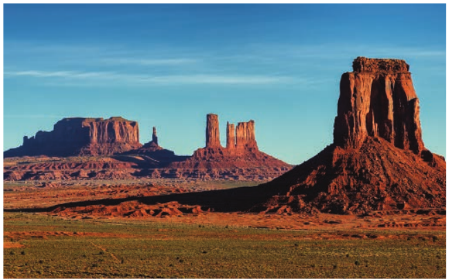
Derived from the Spanish word for table, mesas are isolated flat-topped plateaux or hill-like features with steep slopes or cliffs on at least one side, often falling away to a wadi or canyon. Buttes closely resemble mesas but are much smaller. Both are remnants of heavily dissected plateaux where water has eroded all but a thin isolated rock pillar.
The lower slopes of both features are covered by scree resulting from mechanical weathering and rock fall from the upper sections. Monument Valley National Park in Arizona is home to some of the most spectacular examples of these features.
Inselbergs are more rounded steep-sided hills that rise abruptly from a lowland plain. They are characteristic of tropical savanna zones but are found across various climatic zones. They are generally composed of solid crystalline rocks such as granite.
There has been considerable debate about the processes that formed inselbergs, though most geographers agree they are relict features of previous geomorphological processes. One theory suggests the surrounding slopes retreated in parallel as pediments encroached into the remaining highlands through a process called pediplanation. Others argue they result from deep chemical weathering when the resistant rock was buried beneath the surface and has since been exposed by subsequent removal of surrounding regolith.
Both mechanisms suggest that the desert environments where inselbergs are found today were once more humid, supporting the theory that deserts experienced wetter periods (called pluvials) in the past.
Characteristic desert landscapes through time
Diversity of desert landscapes
When considering characteristic desert landscapes, sand immediately comes to mind for many people. However, hot desert landscapes encompass some of the most spectacular and varied scenery in the world, ranging from seemingly endless flat plains to fields of massive dunes and exceptional mountainous terrain.
From massive dune fields to mountain ranges, deserts are home to remarkable features that attract millions of tourists annually. Examples include Uluru in the Red Centre of Australia and the Grand Canyon in southwestern USA. What distinguishes a desert landscape from others is the lack of vegetation, leaving the geological structure and geomorphological features clearly visible.
Unique combinations of processes and time
No two hot desert landscapes are identical due to the unique interaction of processes, time and landforms in different locations. Each desert landscape results from the processes explored earlier in this chapter and comprises unique assemblages of the features and landforms discussed.
Several factors contribute to the remarkable diversity of hot desert landscapes:
Speed and nature of weathering: Rocks break down more quickly in areas with greater diurnal temperature ranges, where more rapid cycles of heating and cooling affect different minerals in rocks.
Presence of moisture: The amount and availability of water in different locations leads to the formation of different landscapes. Moisture can accelerate weathering processes, including the growth of salt crystals or frost shattering, particularly where temperatures fluctuate rapidly. Where moisture is present, deserts are more likely to have landscapes with biological and organic features, from lichens and bacteria to grasses and cacti.
Rate of landscape formation: The speed at which desert landscapes develop is heavily dependent on time. Some deserts experience extreme temperature fluctuations on a daily basis, whilst others have more moderate diurnal ranges. Some will regularly have moisture present, whilst others remain completely arid for years.
Temporal aspects of landscape development
The landscape of a hot desert may be dominated by erosional or depositional landforms, and these may be either aeolian or fluvial in origin. The rate of formation will vary depending on the presence of wind and flowing water, which may be constant, seasonal or sporadic, depending on the climate.
Water and wind not only have the power to shape the present-day desert landscape, but may also have played a fundamental role in the geological history of the landscape:
-
Some landscapes contain features that record a much wetter past, where great rivers may once have flowed through areas that are now almost completely arid. For example, the presence of inselbergs indicates that an area was once far wetter than it is today.
-
Some desert landscapes may be dominated by features that are relatively recent, such as alluvial fans at the mouth of wadis that may have developed over hundreds to a few thousand years.
-
Other desert landscapes are truly ancient, like the great 'shield deserts', including much of central Australia, which is dominated by vast almost featureless plains with rare outcrops of resistant rock, like Uluru.
Wind and water have been slowly wearing away these landscapes since the ancient super-continents, like Gondwana, broke up between 100 and 200 million years ago. In truth, no two deserts are exactly alike.
Key Points to Remember:
-
Water plays a crucial role in desert landscapes despite low rainfall - intense storms create powerful sheet floods and channel flash floods that cause significant erosion and deposition.
-
Wind creates distinctive erosional features through sand-blasting, including ventifacts (abraded rocks), yardangs (streamlined ridges), and zeugen (rock pedestals and pillars with undercutting).
-
Sand dunes form when specific conditions are met: adequate sand supply, steady prevailing winds, and obstacles to trap sediment. Different dune types include barchans (crescents), seif dunes (linear ridges), transverse, parabolic and star dunes.
-
Fluvial landforms include wadis (dry valleys), alluvial fans (sediment deposits at wadi exits), bajadas (coalescing fans), pediments (gentle rock slopes), and playas (temporary salt lakes).
-
Desert landscapes are highly diverse and result from unique combinations of wind and water processes, local geology, climate, and time. Features may be ancient (like inselbergs from wetter past climates) or relatively recent (like alluvial fans), creating the spectacular variety seen in deserts worldwide.