Quantitative and Qualitative Skills (AQA A-Level Geography): Revision Notes
Quantitative and Qualitative Skills
Introduction to research methods in hot desert environments
Geography utilises both quantitative and qualitative research techniques to investigate environmental systems and processes. Understanding when and how to apply each approach is fundamental to effective geographical research. These methods are explored in detail in Chapter 12 of your course materials.
Conducting fieldwork directly in hot desert environments presents significant challenges for most students. However, it remains essential to understand how different research methods can be applied to study desert landscapes and processes. Most hot deserts are remote and inaccessible, making it crucial to reflect on how various quantitative and qualitative skills could be utilised effectively in these environments.
Hot desert fieldwork is particularly challenging due to extreme temperatures, remoteness, and harsh environmental conditions. Despite these difficulties, understanding research methodologies applicable to these environments is essential for geographical studies.
This section examines how both approaches contribute to understanding hot desert systems, with particular focus on sand dune landscapes. These areas are typically dry and dominated by aeolian (wind-driven) processes, making them ideal contexts for exploring different research methodologies.
Quantitative data collection in twenty-first century desert research
The power of satellite technology
Satellite technology represents one of the most effective methods for gathering quantitative data about hot desert environments. This approach has proven particularly valuable for monitoring the ongoing process of desertification over the past 30 years.
The Landsat programme exemplifies this technological advancement. This collaboration between NASA and the United States Geological Survey (USGS) commenced in 1972. Landsat 8, operational since 2013, continues to provide robust evidence for the geographical spread of desertification processes. Landsat 7, which launched in 1999, has now been succeeded by Landsat 9 in 2021.
Temporal analysis through satellite imagery
A key strength of the Landsat system lies in its ability to capture images of identical geographical locations across different time periods. When images are taken during the same growing season, they reveal where significant landscape changes have occurred. This temporal comparison is invaluable for tracking environmental change.
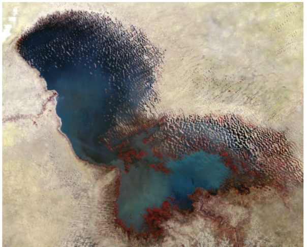
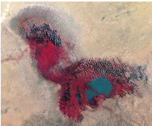
These satellite images demonstrate the dramatic shrinking of Lake Chad between 1973 and 2017, illustrating how Landsat technology tracks environmental change over time.
GIS and remote sensing applications
Powerful geographical information systems (GIS) and geospatial mapping techniques enable researchers to apply sophisticated analytical tools to satellite imagery. High-specification software can apply different filters to identify specific changes to desert surfaces, including:
- Vegetation cover extent and density
- Soil characteristics and composition
- Water content and moisture levels
- Cover patterns across the landscape
- Surface temperatures and thermal properties
These quantitative measurements provide precise data about environmental conditions and changes occurring in desert regions.
Global databases and integrated approaches
Contemporary research increasingly combines multiple data sources. Scientists are developing global databases that integrate field observations with remotely sensed data. Researchers on the ground record changes in land use patterns, which are then analysed alongside satellite imagery. This integrated approach enables comprehensive documentation of both the extent and impacts of desertification across different regions.
Qualitative data collection in twenty-first century desert research
Understanding the complexity of desertification
Desertification is a multifaceted environmental issue. Numerous researchers emphasise that understanding its causes requires more than just quantitative measurements. Whilst empirical data excellently documents the existence and geographical extent of desertification, it cannot explain the underlying social and economic factors driving the process.
The Limitation of Quantitative Data Alone
Quantitative data reveals what is happening and where it occurs, but it cannot explain why local populations engage in practices that degrade their environment. Understanding the human dimensions of desertification requires qualitative research methods.
Qualitative research techniques provide opportunities to explore these human dimensions. Understanding why desertification occurs requires investigation into the connections between social and economic factors and local development pathways that produce and intensify land degradation.
In-depth interviews as a research method
One particularly effective qualitative approach involves conducting in-depth interviews with affected communities. A study conducted on the Greek island of Lesvos demonstrates this methodology. Researchers prepared their interview framework in advance but deliberately avoided formulating specific research hypotheses.
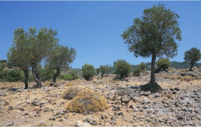
Soil degradation in Lesvos, Greece - the landscape studied through qualitative interview methods.
By not using leading questions, researchers successfully collected extensive information about the experiences and perspectives of local respondents. This open approach allowed participants to share their genuine thoughts without being directed towards particular conclusions.
Interview themes and structure
The interview schedule used with local farmers in Greece explored five key themes:
- Characteristics of respondents and their farming practices - understanding who is affected and how they work the land
- Views on rural development and development processes - exploring perceptions of change and progress in rural areas
- Views on local socio-economic conditions - examining the economic context influencing land management decisions
- Community resilience - investigating alternative employment opportunities, income diversification and social relationships
- Views on desertification and land degradation problems - understanding local perceptions of environmental issues
Coding and analysing qualitative data
In-depth interviews generate substantial amounts of information that requires systematic organisation. This qualitative data must be coded - organised into different categories to enable detailed analysis.
Understanding Coding
Coding is the process of categorising qualitative information into thematic groups, enabling researchers to identify patterns and draw meaningful conclusions from interview data. This systematic organisation transforms raw interview content into analysable categories.
The researchers suggest it is impossible to formulate effective solutions to desertification without fully comprehending the motivations and circumstances of local populations in affected areas. This depth of understanding can only be achieved through qualitative techniques that explore human experiences, perspectives and decision-making processes.
Understanding why communities make particular land management choices is essential for developing appropriate interventions. Solutions imposed without this understanding risk being ineffective or even counterproductive.
Practical applications
Skills focus question
Reflect on GIS Applications
Consider how geographical information systems (GIS) and remotely sensed data could be valuable for monitoring desertification processes. What specific advantages do these technologies offer? How might they be combined with other data sources to provide comprehensive understanding?
Fieldwork opportunities
The Toubkal National Park and surrounding region offers accessible fieldwork opportunities. Located approximately two hours' drive from Marrakesh in Morocco, this area provides possibilities for studying water management practices in the margins of a hot desert environment. Additionally, situated on the edge of the Saharan desert, this location enables investigation of desertification impacts and their potential effects on local populations and their livelihoods.
Remember!
Key Points to Remember:
-
Satellite technology, particularly Landsat, provides powerful quantitative data about desert environments, enabling temporal comparison of landscape changes over decades.
-
GIS and remote sensing filter satellite imagery to identify specific environmental variables including vegetation cover, soil characteristics, water content and surface temperatures.
-
Quantitative methods reveal the extent of desertification but cannot explain the underlying human causes and motivations driving environmental degradation.
-
Qualitative techniques like in-depth interviews are essential for understanding why local populations make land management decisions that may contribute to desertification.
-
Coding qualitative data into categories enables systematic analysis of complex social and economic factors influencing environmental change in desert regions.