Physical processes (Edexcel GCSE Geography A): Revision Notes
Physical processes in changing UK landscapes
Introduction to physical processes
The distinctive upland and lowland landscapes we see across the UK today have been shaped by various physical processes working together over thousands of years. These processes include glacial activity, weathering, climate effects, and river action. Understanding how these processes interact helps us explain why different parts of Britain look so different from each other.
The diversity of UK landscapes reflects the complex interaction of multiple geological and climatic processes operating over different timescales. Some features formed millions of years ago, while others continue to develop today.
Upland landscape formation
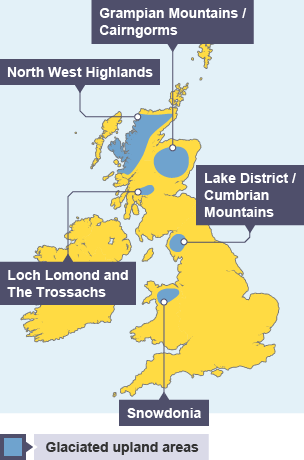
Upland areas in the UK show clear evidence of past glacial activity combined with ongoing weathering processes. The Lake District provides an excellent example of how these processes have worked together to create today's mountainous landscape.
Glacial erosion
During the Ice Age, massive glaciers moved across the landscape, carving out distinctive features that we can still see today. In places like Stickle Tarn in the Lake District, glaciers carved out bowl-shaped depressions called corries. These deep, circular hollows were formed as glaciers rotated and scraped away the bedrock beneath them. The steep back walls and relatively flat floors of these features provide clear evidence of glacial erosion.
Glacial erosion also created the characteristic U-shaped valleys found throughout upland Britain. Unlike river valleys which tend to be V-shaped, glacial valleys have wide, flat floors and steep sides where the ice carved away the landscape.
The key difference between glacial and river valleys is their cross-sectional shape: glacial valleys are U-shaped with wide, flat floors, while river valleys are typically V-shaped. This distinction provides crucial evidence for identifying past glacial activity.
Weathering processes
Weathering continues to shape upland landscapes today, particularly through freeze-thaw action. When water gets into cracks in the rock and freezes, it expands, widening the cracks. Over time, this process breaks off fragments of rock that fall down the mountainside. These broken rock pieces collect at the bottom of cliffs to form sloping piles of debris called scree slopes.
The exposed rock faces in upland areas are particularly vulnerable to this type of weathering because they experience frequent temperature changes around the freezing point, especially during winter months.
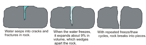
Freeze-thaw weathering is most effective when temperatures regularly fluctuate around 0°C. This is why upland areas, with their exposure to temperature variations, show such clear evidence of this process in the form of scree slopes and broken rock faces.
Climate effects
The high rainfall typical of upland areas creates additional challenges for the landscape. Water cannot soak into impermeable rocks, so it flows rapidly over the surface, creating numerous streams and contributing to erosion. The combination of high precipitation and steep slopes means that surface water moves quickly, carrying away loose material and continuing to modify the landscape.
Post-glacial rivers
An interesting feature of many upland valleys is that the streams running through them today seem too small for the valleys they occupy. This is because these U-shaped valleys were carved by glaciers, not by the relatively small streams we see now. The valley floors are much wider than the current streams could have eroded, providing evidence of the much more powerful glacial forces that once shaped these landscapes.
This mismatch between valley size and current river size is called "under-fit streams" and provides compelling evidence that these valleys were carved by much more powerful forces - the glaciers of the Ice Age.
Lowland landscape formation
Lowland areas of the UK have been shaped primarily by river processes operating over thousands of years. The landscape of Herefordshire demonstrates how rivers create wide valleys through erosion and deposition.
River erosion
As rivers flow through the landscape, they gradually erode the land around them, particularly as they meander from side to side. Over time, this lateral erosion widens valleys and creates the gently rolling terrain characteristic of lowland Britain. Rivers like the Lugg and Wye have carved broad valleys between low hills through this process of gradual erosion and sediment transport.
The meandering nature of lowland rivers means they constantly change course slightly, eroding material from the outside of bends while depositing it on the inside. This process slowly widens valleys and creates the flat-bottomed profile typical of river valleys.
River deposition
When rivers flood during periods of heavy rainfall, they deposit the sediment they have been carrying across the surrounding land. Over many flood events, this process builds up layers of fertile silt, creating wide, flat floodplains. These floodplains are characteristic features of lowland landscapes and explain why many lowland areas have such flat, productive farmland.
The alternating processes of erosion during normal flow and deposition during floods work together to create the gentle, undulating landscapes typical of lowland Britain.
River floodplains are not just geographical features - they represent thousands of years of sediment deposition during flood events. This is why floodplain soils are typically so fertile and why these areas have been favoured for agriculture throughout history.
Case study: Bowerman's Nose, Dartmoor
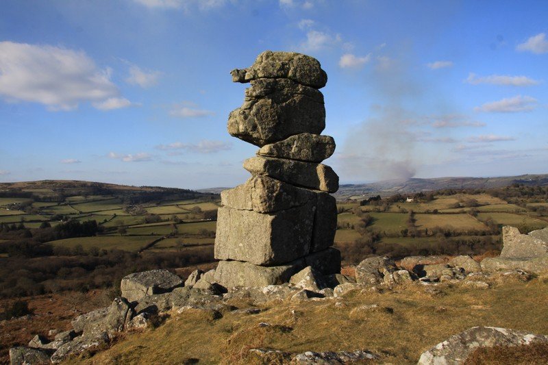
Dartmoor's granite tors, such as Bowerman's Nose, provide excellent examples of how multiple physical processes work together to create distinctive landscape features. The formation of these impressive rock stacks involves several stages of geological and weathering processes.
Worked Example: Tor Formation Process
Step 1: Underground formation (290 million years ago)
- Molten rock (magma) formed a large underground body called a batholith
- Slow cooling created granite with distinctive jointed structure
Step 2: Exposure
- Overlying rocks gradually worn away over millions of years
- Granite exposed at surface and vulnerable to weathering
Step 3: Weathering and erosion
- Chemical weathering attacked joints in granite
- Loose blocks removed by erosion and mass movement
- Freeze-thaw weathering broke up surface layers
Step 4: Tor formation
- More resistant granite blocks remained as tors
- Less resistant areas worn away
- Scattered boulders created around tor bases
Formation process
The story of Dartmoor's tors begins deep underground around 290 million years ago. A large body of molten rock (magma) formed what geologists call a batholith beneath the surface. As this magma cooled very slowly, it formed granite - a hard, crystalline rock with a distinctive jointed structure.
Over millions of years, the rocks above the granite were gradually worn away, exposing the granite at the surface. Once exposed, the granite became vulnerable to weathering processes, particularly chemical weathering which attacked the joints in the rock, gradually widening them.
Weathering and erosion effects
Chemical weathering works particularly effectively on granite because it attacks the minerals that hold the rock together. As the joints in the granite widened, blocks of rock became loose and were gradually removed by erosion and mass movement processes.
The areas of granite most affected by weathering and erosion were worn away, leaving behind the more resistant blocks that now form the tors. Freeze-thaw weathering also played a role, particularly in breaking up the surface layers of granite and creating the scattered boulders found around many tors.
This combination of processes - underground formation, exposure, chemical weathering, and physical erosion - working together over millions of years created the dramatic granite landscapes we see on Dartmoor today.
Key Points to Remember:
- Physical processes work together: UK landscapes result from multiple processes operating simultaneously, not just one type of erosion or weathering
- Glacial evidence remains: Many upland features like U-shaped valleys and corries provide clear evidence of past ice age activity
- Rivers shape lowlands: Meandering rivers create wide valleys through lateral erosion and build floodplains through repeated flooding and deposition
- Weathering continues: Freeze-thaw weathering actively shapes upland landscapes today, creating scree slopes and breaking down exposed rock faces
- Time creates complexity: Features like granite tors require millions of years and multiple processes to develop their distinctive appearance