Lower course landscape 1 (Edexcel GCSE Geography A): Revision Notes
Lower course landscape 1
In the lower course of a river, distinctive landforms are created through depositional processes. These include floodplains, levées, and point bars - all formed when the river slows down and deposits the sediment it has been carrying.
Floodplains
A floodplain is a broad, flat area of land found on either side of a river that gets covered with water when the river overflows its banks during flooding events.
Floodplains are some of the most fertile agricultural areas in the world because of the nutrient-rich sediment deposited during flooding events.
How floodplains form
In the lower course, rivers are approaching the sea and carry enormous amounts of sediment called alluvium. Several key processes work together to create floodplains:
When the river floods, excess water spreads across the surrounding landscape. As this happens, the river's velocity drops significantly, causing it to lose energy and deposit the sediment it was carrying. This creates the flat floodplain surface.
The floodplain's shape develops through lateral erosion as meanders gradually shift downstream over time. Material is also deposited on the inner bends of these meanders, further building up the floodplain area.
The key to floodplain formation is the relationship between river velocity and energy - when the river slows down during flooding, it loses the energy needed to carry sediment and must deposit it instead.
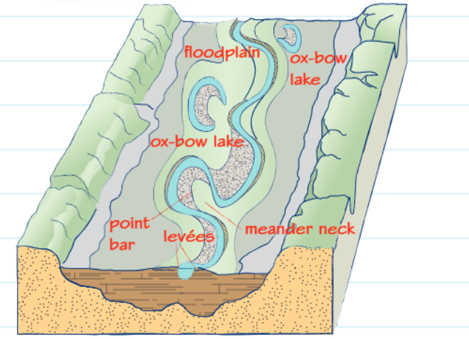
How levées develop
Levées are natural raised embankments that form alongside rivers through a gradual depositional process that occurs during repeated flooding events.
The formation process
During flooding, the heaviest sediment gets deposited first because the river loses energy quickly as it overflows. This heavier material creates natural embankments right beside the river channel.
After each flood, finer sediment and alluvium gets deposited further away from the river because it requires less energy to transport. Over many flood cycles, these embankments grow higher and create the distinctive levée landforms we observe.
Natural levées can reach heights of several metres and act like natural flood defences, though they can sometimes be breached during particularly severe flooding events.
The process continues with each flooding event, making the levées progressively taller and more prominent features of the landscape.
Point bars
Point bars are curved depositional features that form on the inside bends of river meanders where the current moves more slowly.
Formation of point bars
On the inside bends of meanders, the river current is relatively slow and has low energy. This means the river cannot transport its sediment load effectively, so material gets deposited instead. Over time, deposits of sand, silt, and pebbles accumulate to form the distinctive curved shape of a point bar.
This process contrasts with what happens on the outside bends, where faster-flowing water causes erosion rather than deposition.
Remember the key contrast: inside bends = slow current = deposition = point bars, while outside bends = fast current = erosion = river cliffs.
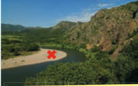
Identifying river landforms
When studying photographs or diagrams of river landscapes, look for these key features to identify lower course landforms:
- Wide, flat areas beside the river indicate floodplains
- Raised banks running parallel to the river show levées
- Curved sandy or rocky deposits on meander bends reveal point bars
- Ox-bow lakes demonstrate where old meanders have been cut off
Understanding these formation processes helps explain why lower course rivers have such distinctive, depositional landscapes compared to their upper course counterparts.
Geographers often use aerial photographs and topographic maps to identify these landforms, as the patterns are most clearly visible from above.
Key Points to Remember:
- Lower course rivers create landforms through deposition when they lose velocity and energy
- Floodplains form when rivers overflow and deposit sediment across wide, flat areas
- Levées develop as natural embankments through repeated flooding, with heavier sediment deposited closest to the channel
- Point bars occur on the inside bends of meanders where slow currents allow sediment to accumulate
- All these features work together to create the characteristic flat, wide valleys found in lower course river landscapes