Weather and climate challenges (Edexcel GCSE Geography A): Revision Notes
Weather and climate challenges
Weather and climate patterns significantly influence river systems across the UK, creating various challenges that affect how rivers behave and shape the landscape. Understanding these relationships is crucial for predicting and managing river-related risks like flooding and erosion.
The relationship between weather, climate, and river systems is fundamental to understanding flood risk management and landscape evolution. These connections help explain why some areas are more prone to flooding than others.
How climate affects river processes
Climate conditions directly control several key river processes, each responding differently to changes in temperature, precipitation, and seasonal patterns.
Discharge and erosion relationships
The amount of water flowing through a river (discharge) has a profound impact on its ability to erode the landscape. When climate conditions lead to higher discharge - such as during prolonged wet periods or intense rainfall events - rivers gain significantly more erosive power. This increased energy allows them to cut deeper into their channels and remove more material from riverbanks and beds.
In wetter climates, rivers consistently carry more water, meaning they can continuously erode more material compared to rivers in drier regions. This relationship explains why some river valleys are much deeper and wider than others, depending on their local climate conditions.
Key relationship: As discharge increases, erosive power increases exponentially, not just proportionally. This means even small increases in water flow can lead to dramatically more erosion.
Sediment transport capacity
The energy available in flowing water determines how much sediment a river can carry. Rivers in wetter climates, with their higher discharge levels, possess greater energy and can therefore transport much larger amounts of material downstream. This includes everything from fine particles like clay and silt to larger materials like pebbles and boulders.
During dry periods, reduced water flow means rivers lose much of their transport capacity, causing them to deposit sediment they were previously carrying. This process helps explain how river channels and floodplains change shape over time.
Weathering processes
Temperature fluctuations caused by climate patterns affect how quickly rocks break down around river systems. Freeze-thaw weathering becomes particularly important in areas where temperatures regularly cross the freezing point. When water in rock cracks freezes, it expands and gradually splits the rock apart. Repeated cycles of freezing and thawing can rapidly break down rock faces along river valleys, providing more material for rivers to transport.
Freeze-thaw weathering process: Water expands by approximately 9% when it freezes, creating enormous pressure within rock cracks. This mechanical weathering process is especially effective in upland areas where temperatures frequently fluctuate around 0°C.
Changing weather patterns in the UK
Recent years have brought increasingly extreme weather conditions to the UK, creating new challenges for river management and flood risk.
Increasing storm frequency and intensity
The UK has experienced more frequent periods of heavy, intense rainfall in recent decades. These storm events can dramatically increase the risk of river flooding because they deliver large volumes of water to river systems in short time periods. When rivers cannot cope with this sudden influx of water, they overflow their banks and flood surrounding areas.
Storm events are particularly dangerous because they can cause rapid changes in river behaviour. The sudden increase in discharge and velocity during storms enhances the river's erosive power, allowing it to reshape channels quickly and potentially damage infrastructure.
Critical flood risk factor: Storm events create a double threat - not only do they increase flood risk through higher discharge, but they also increase erosion rates that can undermine bridges, buildings, and flood defences.
Extended dry periods
Climate change has also brought longer periods of hot, dry weather to many parts of the UK. During these periods, the upper layers of soil become baked hard and lose their ability to absorb water effectively. When rain eventually arrives after a dry spell, water cannot soak into the ground as it normally would. Instead, it runs rapidly across the surface, reaching rivers quickly and causing discharge to rise sharply. This surface runoff can lead to sudden flooding even from relatively modest rainfall amounts.
Counterintuitive flooding: This explains why some of the most serious floods occur after dry spells rather than during consistently wet periods. The soil's inability to absorb water creates conditions similar to flooding on concrete surfaces.
Cold weather impacts
Cold conditions create their own challenges for river systems. When soil becomes frozen or waterlogged, it becomes impermeable - meaning water cannot infiltrate into the ground. Snowmelt during warmer periods can also contribute large volumes of water to rivers very quickly. Both scenarios increase flood risk by forcing more water to flow directly into river channels rather than being absorbed by surrounding land.
Impermeable surface effect: Frozen ground acts like a giant impermeable surface, similar to concrete or tarmac. This forces nearly all precipitation to become surface runoff, dramatically increasing the speed at which water reaches river systems.
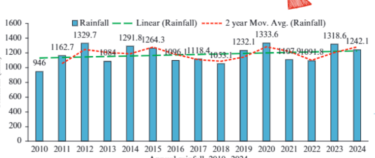
Understanding rainfall patterns like those shown in this data helps predict how river systems might respond to varying weather conditions. The chart demonstrates how annual rainfall can fluctuate significantly from year to year, with these variations directly affecting river discharge and associated flood risks.
Analysing weather impacts on rivers
When examining how weather patterns affect river systems, it's essential to consider both immediate and longer-term impacts. Storm events can cause immediate increases in river discharge and velocity, leading to enhanced erosion and sediment transport. This increased hydraulic action and abrasion can widen and deepen river channels rapidly.
The effects extend beyond the channel itself. Flood events deposit sediment across floodplains, gradually raising their height. This process also builds up natural levees - raised banks that run parallel to the river channel. Over time, these changes alter the river's relationship with its surrounding landscape.
System-wide connectivity: River systems are interconnected networks. A storm in the upland headwaters can cause flooding problems many hours or even days later in lowland areas hundreds of kilometres downstream.
Extreme weather events don't just affect individual rivers in isolation. They can impact entire river systems, from small tributaries in upland areas all the way down to major rivers flowing through urban areas. Understanding these connections helps explain why weather events in one area can cause flooding problems many kilometres downstream.
Essential for flood prediction: Understanding the time lag between weather events and their downstream impacts is crucial for effective flood warning systems and emergency response planning.
Key Points to Remember:
- Climate directly controls river power: Higher discharge from wet conditions increases both erosion rates and sediment transport capacity
- Extreme weather increases flood risk: More frequent storms and longer dry periods both contribute to sudden increases in river discharge
- Temperature affects weathering: Freeze-thaw cycles provide more material for rivers to erode and transport
- Soil conditions matter: Dry, baked soil and frozen ground prevent water infiltration, forcing more surface runoff into rivers
- Weather impacts are connected: Changes in upland areas can affect river behaviour many kilometres downstream