Bearings (Edexcel GCSE Maths): Revision Notes
Bearings
What are bearings?
Bearings are a way to describe direction using angles measured from north. They're incredibly useful for navigation, whether you're sailing, hiking, or solving maths problems. Think of bearings as a precise way to give directions - instead of saying "go that way," you can say "go on a bearing of " which tells someone exactly where to head.
Bearings are used extensively in real-world navigation systems, from ship navigation to GPS technology. Understanding bearings gives you the foundation for reading maps, using compasses, and understanding how modern navigation works.
The three-step method for finding bearings
To successfully work with bearings, you need to master a simple three-step process that uses three key concepts. This method works for any bearing problem you'll encounter.
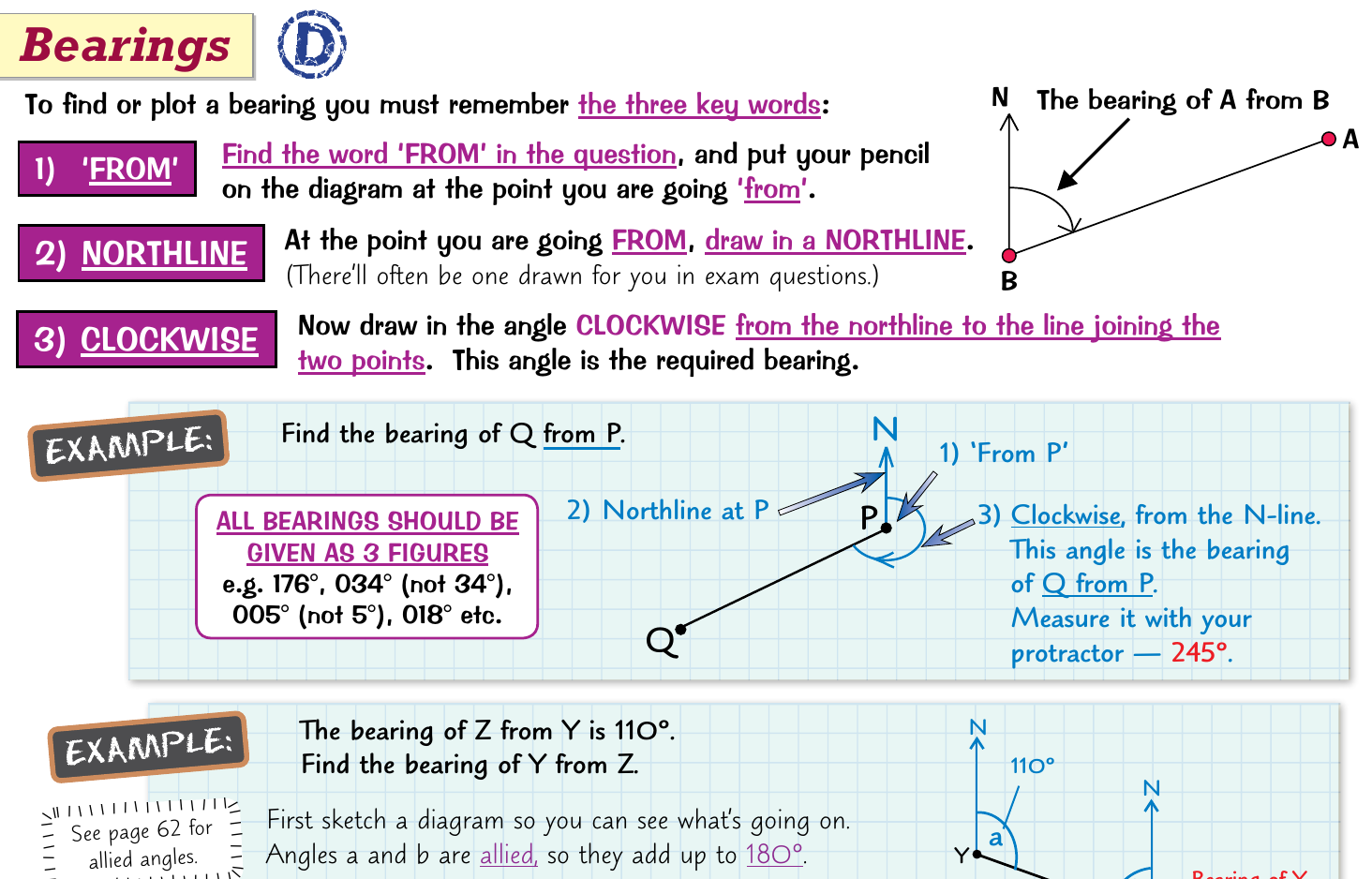
The Three Key Steps for Any Bearing Problem:
- FROM - Find your starting point
- NORTHLINE - Draw a vertical line pointing north
- CLOCKWISE - Measure the angle clockwise from north
Remember this sequence: FROM → NORTHLINE → CLOCKWISE
Step 1: Find the "FROM" point
The first step is to identify where you're measuring from. Look for the word "FROM" in the question - this tells you your starting point. Place your pencil or finger on this point in the diagram, as this is where you'll begin your measurement.
Step 2: Draw the northline
At your starting point (the FROM point), you need to draw a vertical line pointing north. This northline is your reference point for measuring the bearing. In exam questions, this line is sometimes already provided, but you should always check and draw one if it's missing.
Step 3: Measure clockwise from north
Now you measure the angle clockwise from the northline to the line connecting your two points. This clockwise angle is your bearing. Remember - it's always clockwise from north, never anticlockwise.
Worked Example: Finding a Basic Bearing
Question: Find the bearing of point B from point A.
Step 1: Identify the FROM point
- The question asks for "B from A", so A is our FROM point
Step 2: Draw the northline
- Draw a vertical line pointing north from point A
Step 3: Measure clockwise
- Measure the angle clockwise from the northline to the line AB
- If this angle is , then the bearing of B from A is
Understanding three-figure bearings
All bearings must be written as three-figure numbers, even if the angle is less than . This is a crucial rule that many students forget.
Three-Figure Format Rule:
- becomes
- becomes
- stays as
This three-figure format prevents confusion and is the standard way bearings are written in navigation and mathematics.
Working with reverse bearings
Sometimes you'll need to find the bearing in the opposite direction. For instance, if you know the bearing of Z from Y is , you might need to find the bearing of Y from Z. This involves understanding how angles work in a complete circle.
When dealing with reverse bearings, you can use the concept of allied angles. If two points are connected by a straight line, the bearings in opposite directions are related by either adding or subtracting , depending on which gives you an angle between and .
Worked Example: Reverse Bearing Calculation
Given: The bearing of Z from Y is Find: The bearing of Y from Z
Step 1: Understand the relationship
- Points Y and Z are connected by a straight line
- The reverse bearing uses allied angles
Step 2: Calculate the reverse bearing
- If the original bearing is less than , add
- If the original bearing is greater than , subtract
Step 3: Apply the rule
- Original bearing: (less than )
- Reverse bearing:
- Therefore, the bearing of Y from Z is
Bearings with scale drawings
Bearings become even more powerful when combined with scale drawings and distance calculations. This allows you to solve real-world navigation problems involving both direction and distance.
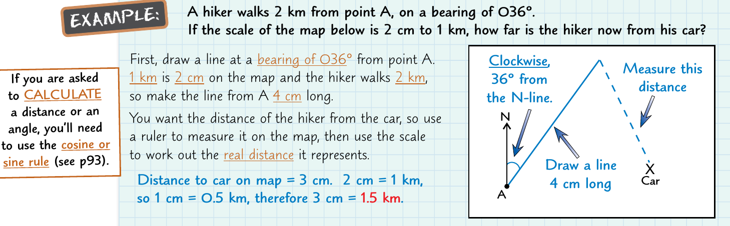
When working with scale drawings, you'll often need to:
- Use the given bearing to draw a line in the correct direction
- Apply the scale to convert between map distances and real distances
- Use measurement tools to find distances on the map
- Convert these measurements back to real-world distances
Scale conversion is crucial for practical applications. For example, if a map scale shows that 2 cm represents 1 km, and you measure a distance of 3 cm on the map, the real distance would be 1.5 km.
Worked Example: Bearings with Scale Drawings
A hiker walks on a bearing of for 4 km, then changes direction to a bearing of for 3 km.
Step 1: Set up the scale drawing
- Choose a suitable scale (e.g., 1 cm = 1 km)
- Mark the starting point
Step 2: Draw the first leg
- From the starting point, draw a northline
- Measure clockwise from north
- Draw a line 4 cm long in this direction
Step 3: Draw the second leg
- From the end of the first leg, draw a new northline
- Measure clockwise from north
- Draw a line 3 cm long in this direction
Step 4: Find the final position
- The end of the second leg is the hiker's final position
- Measure the direct distance and bearing from start to finish
Practical applications
Understanding bearings opens up many practical applications beyond maths exams. Navigation systems, surveying, and even computer graphics use bearing concepts. When you give someone directions using compass points, you're using a simplified version of bearings.
Modern GPS systems use bearing concepts combined with satellite positioning to provide accurate location and direction information. The principles you learn here form the foundation of these advanced navigation technologies.
The key to mastering bearings is practice with the three-step method. Once you can automatically identify the FROM point, draw the northline, and measure clockwise, you'll find bearing problems become much more manageable.
Key Points to Remember:
- Always follow the three-step method: FROM → NORTHLINE → CLOCKWISE
- All bearings must be written as three-figure numbers (, , )
- Bearings are always measured clockwise from north
- The "FROM" point is where you start your measurement, not where you're going
- For reverse bearings, add or subtract depending on the original angle
- When working with scale drawings, remember to convert between map distances and real distances