Physical Geography of the UK (OCR GCSE Geography B (Geography for Enquiring Minds)): Revision Notes
Physical Geography of the UK
Introduction
The UK's physical geography is characterised by distinct patterns in relief (the height and shape of the land) and rainfall distribution. Understanding these patterns is essential for explaining climate variations, water availability, and regional differences across the country.
Relief and rainfall patterns are interconnected. The height and position of mountains directly influence where and how much rain falls, creating the UK's distinctive climate regions.
Relief patterns in the UK
Relief refers to the variations in height and shape of the land surface. The UK displays clear regional differences in its physical landscape, with a distinctive pattern of uplands in the north and west contrasting with lowlands in the south and east.
Distribution of upland and lowland areas
Mountains and upland regions are concentrated in the north and west of the UK. Major upland areas include:
- Scottish Highlands – the highest and most extensive upland area
- Grampians – mountain range in central Scotland
- Cairngorms – high mountains in eastern Scotland
- Pennines – often called the 'backbone of England', running north-south
- Lake District – mountainous region in north-west England
- Cambrian Mountains – upland region in Wales
- Brecon Beacons – mountain range in south Wales
In contrast, lowland areas dominate the south and east of the UK, particularly across central and southern England. These areas typically lie below 200 metres above sea level.
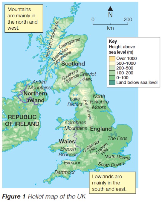
Critical Pattern to Remember:
There is a clear diagonal divide across the UK:
- North and west = mountainous uplands (over 200m elevation)
- South and east = flat lowlands (below 200m elevation)
This pattern is fundamental to understanding all UK climate and rainfall distributions.
Why relief matters
Relief has a significant influence on both weather patterns and climate. The height and position of mountains affect wind movement, temperature, and particularly rainfall distribution across the UK.
Rainfall patterns in the UK
The UK experiences substantial variation in rainfall amounts across different regions, closely linked to relief patterns.
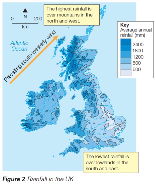
Prevailing winds and their origin
The UK's dominant wind direction comes from the south-west, blowing across the Atlantic Ocean. These winds are known as prevailing south-westerly winds. As they travel over the ocean, they pick up large amounts of moisture, creating moist air masses.
The Atlantic Ocean acts as a massive moisture source. As winds blow over thousands of kilometres of open water, they absorb water vapour through evaporation, arriving at the UK carrying large quantities of moisture ready to fall as rain.
Relief rainfall process
Relief rainfall occurs when moist air is forced to rise over mountains and upland areas. This is the primary mechanism producing the UK's rainfall patterns.
Worked Example: Relief Rainfall Formation
Step 1: Moist air from the Atlantic Ocean approaches the UK from the south-west
Step 2: When this air meets mountains (e.g., the Cambrian Mountains in Wales), it is forced upwards
Step 3: As the air rises, it cools down (temperature decreases with altitude)
Step 4: Cooling causes water vapour to condense, forming clouds and producing rainfall
Step 5: This creates high rainfall totals over mountainous regions (the windward side)
Step 6: Air then descends on the eastern side of mountains, warms up, and produces low rainfall (the leeward side)
Regional rainfall distribution
Rainfall amounts vary dramatically across the UK, creating a clear geographical pattern:
Highest rainfall (over 2,000mm per year):
- Occurs over mountainous areas in the north and west
- Western Scotland can receive over 2,400mm annually
- North-west England and western Wales also experience very high totals
Lowest rainfall (around 600mm per year):
- Found over lowland areas in the south and east
- South-east England receives the least rainfall
- Eastern England generally has lower rainfall totals
This creates a clear west-to-east rainfall gradient across the UK.
Why the West is Wetter:
The combination of three factors creates maximum rainfall in western uplands:
- Prevailing winds arrive from the south-west carrying Atlantic moisture
- Mountains force this moist air upwards
- Rising air cools and condenses, producing heavy rainfall
The east receives less rainfall because air has already lost most of its moisture over western mountains and is descending and warming.
Water stress in the UK
What is water stress?
Water stress occurs when the demand for water exceeds the available water supply. This represents a mismatch between how much water people need and how much is naturally available.
Where water stress occurs
Water stress mainly affects the south-east of England. This region experiences a combination of two critical factors that create a perfect storm for water shortage:
- High population density – many people living in a relatively small area, creating high water demand
- Low rainfall – the region receives some of the UK's lowest annual rainfall totals (around 600mm), creating low water supply
This creates significant challenges for water supply management.
Understanding the Problem:
South-east England contains approximately 30% of the UK's population but receives some of the lowest rainfall. London and surrounding areas have a population density far higher than the national average, meaning millions of people compete for limited water resources in one of the driest parts of the country.
Solutions to water stress
One proposed solution involves large-scale water transfer:
- Pipe water from areas of high supply and low demand (north-west England, Wales, Scotland)
- Transfer it to areas of low supply and high demand (south-east England)
- This would help balance water availability across the country
However, such schemes are expensive and raise environmental concerns.
Challenges with Water Transfer Schemes:
While water transfer could solve supply issues, it faces major obstacles:
- Very high construction and maintenance costs
- Environmental impact on source regions
- Energy required to pump water over long distances
- Political resistance from regions "losing" their water
Exam guidance
Tips for Exam Success:
When answering questions about UK physical geography:
- Describe questions: State patterns clearly (e.g., "Mountains are concentrated in the north and west")
- Explain questions: Link causes and effects (e.g., "Relief rainfall occurs because moist air from the Atlantic is forced to rise over mountains, causing cooling and condensation")
- Use specific place examples: Name actual mountain ranges and regions
- Link relief and rainfall: Show understanding of how they are connected
- Use compass directions accurately: Be precise about north/south/east/west
- Always explain the full process for relief rainfall – don't skip steps
Remember!
Key Points to Remember:
Geographical Patterns:
- Mountains are mainly located in the north and west of the UK; lowlands dominate the south and east
- The UK's prevailing wind blows from the south-west across the Atlantic Ocean
- The highest rainfall (over 2,000mm) falls over western mountains; the lowest (around 600mm) occurs in south-east lowlands
Physical Processes:
- Relief rainfall occurs when moist air rises over mountains, cools, and produces precipitation
- The relief rainfall process: moist air → forced upwards over mountains → cooling → condensation → precipitation
Human Geography:
- Water stress affects south-east England due to high population density and low rainfall
- Water stress equation: demand > supply = water stress
Key Terms to Know: Relief, prevailing wind, relief rainfall, water stress, moist air, population density, upland, lowland, condensation, precipitation, water transfer