Impacts of Climate Change (AQA A-Level Geography): Revision Notes
Impacts of Climate Change
Understanding sea level rise
Global sea levels have been gradually rising for approximately 10,000 years. However, the rate of this increase has accelerated dramatically in recent decades. This acceleration poses significant challenges for coastal regions worldwide, particularly in vulnerable areas like the UK.
The acceleration in sea level rise is not just a gradual increase - the rate has more than doubled in just over a century, representing one of the most measurable impacts of climate change on our planet.
The rate at which sea levels are rising has more than doubled over the past century. Early 20th century measurements show much slower rates compared to recent data collected in the 2000s and 2010s.
Historical patterns of sea level rise
The data clearly demonstrates an accelerating trend in sea level rise:
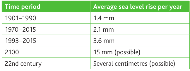
Key observations from these measurements:
- Between 1901 and 1990, sea levels rose at an average rate of 1.4 mm per year
- This rate increased to 2.1 mm per year between 1970 and 2015
- The most recent period (1993-2015) shows an even faster rate of 3.6 mm per year
- This represents more than a doubling of the rate within just over a century
Notice the pattern of acceleration: Each successive measurement period shows the rate nearly doubling. This exponential increase suggests that future rates could accelerate even more rapidly than current models predict.
Future projections suggest this acceleration will continue:
- By 2100, rates could reach 15 mm per year
- In the 22nd century, rates of several centimetres per year are possible
Causes of sea level change
Sea level changes occur through two main mechanisms:
Increases in ocean volume
The volume of water in the oceans is increasing due to two processes:
Thermal expansion: As global temperatures rise due to the enhanced greenhouse effect, ocean water warms and expands. Warmer water takes up more space than cooler water, causing sea levels to rise. This is currently one of the most significant contributors to sea level rise.
Ice sheet melting: Water that has been stored as ice on land (particularly in Greenland and Antarctica) is melting and flowing into the oceans. As this previously frozen water enters the ocean system, it adds to the total volume of seawater.
Unlike ice cubes melting in a drink (which don't raise the water level because the ice is already displacing water), ice sheets on land represent water that was previously stored outside the ocean system. When this ice melts, it represents a net addition to ocean volume.
Coastal subsidence
The second major factor is the lowering of coastal land through subsidence. When coastal areas sink relative to sea level, the effect is similar to the sea rising - low-lying areas become more vulnerable to flooding and erosion.
In the UK, subsidence is particularly significant in certain regions due to geological processes following the last ice age.
Subsidence is the gradual sinking or settling of the ground surface. In coastal areas, this means the land is getting lower relative to sea level, increasing flood and erosion risks even without any change in actual sea level.
Future predictions and uncertainty
Scientists use complex models to predict future sea level rise, but there is considerable uncertainty in these projections. Most predictions suggest global sea levels could rise between 30 cm and 110 cm by 2100.
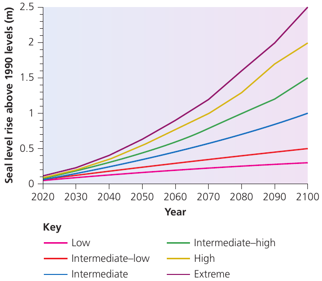
This graph from the National Oceanic Atmospheric Administration (NOAA) shows six different scenarios:
- Low scenario: Approximately 0.3 metres by 2100
- Intermediate scenarios: Range from about 0.5 to 1.5 metres
- Extreme scenario: Could reach 2.5 metres by 2100
Why is there so much uncertainty?
Several factors make accurate prediction difficult:
- Ice sheet behaviour: Scientists are still working to understand exactly how massive ice sheets in Greenland and Antarctica will respond to warming. Their behaviour is complex and difficult to model precisely
- Human mitigation: The extent of future sea level rise depends significantly on human actions to reduce greenhouse gas emissions and mitigate climate change
- Thermal expansion variations: The rate at which oceans warm and expand is influenced by many factors that are challenging to predict accurately
The wide range of scenarios reflects this uncertainty, helping coastal planners prepare for different possibilities. This is why adaptation strategies must be flexible enough to accommodate various potential outcomes.
Impacts on UK coastlines
Rising sea levels will have numerous adverse effects on the UK's coastal regions, creating increased risks that require careful management and mitigation.
Increased coastal flooding
Higher sea levels mean that storm surges and high tides will reach further inland. Areas that previously experienced minimal flooding will face increased flood risk. This poses threats to:
- Major cities including London, Hull and Middlesbrough
- Important transport infrastructure (roads and rail links near the coast)
- Power stations built on low-lying coastal sites
- High-grade agricultural land in coastal regions
Saltwater intrusion occurs when rising sea levels cause seawater to move upstream in rivers or infiltrate underground freshwater supplies. This contamination makes water unsuitable for drinking or irrigation without expensive treatment.
Accelerated coastal erosion
Rising sea levels intensify coastal erosion processes. The UK's east coast has historically been particularly vulnerable, with numerous villages lost since medieval times (recorded in the Domesday Book).
Regional variations in vulnerability
Not all parts of the UK face equal risk. The southeast of England is particularly vulnerable because:
- The land is naturally lower-lying
- The region is experiencing subsidence
This subsidence is linked to post-glacial adjustment. After the last ice age, glacier removal in the north and west of the UK caused those areas to gradually rise (uplift). This uplift has caused corresponding subsidence in the east and southeast, particularly around the North Sea basin.
Understanding post-glacial adjustment:
When massive ice sheets covered northern Britain during the last ice age, their weight pushed down the Earth's crust. As the ice melted, the land beneath began to rise back up - but like a see-saw, this uplift in the north causes the southeast to sink. This process continues today, thousands of years after the ice disappeared.
The combination of rising sea levels and sinking land creates a compounding effect, making relative sea level rise in these areas greater than the global average.
Impacts on freshwater resources
Rising sea levels affect not only the surface but also underground water systems:
- Seawater can mix with freshwater in rivers, moving the mixing zone further upstream
- Saltwater can infiltrate underground freshwater stored in rocks beneath coastal areas
- This contamination can reach water abstraction points used for domestic and agricultural purposes
- Abstraction points may need to be relocated inland, or measures taken to prevent saline water extraction
These impacts represent a significant challenge for water resource management in coastal regions.
Key Points to Remember:
-
Sea level rise has accelerated dramatically - rates have more than doubled from 1.4 mm/year (1901-1990) to 3.6 mm/year (1993-2015), with predictions of 15 mm/year by 2100
-
Two main causes drive sea level change: increases in ocean volume (from thermal expansion and ice melting) and coastal subsidence (land sinking)
-
Predictions for 2100 range widely from 30 cm to 110 cm rise, with significant uncertainty due to ice sheet behaviour and human mitigation efforts
-
The UK's southeast is particularly vulnerable due to the combination of rising seas and subsidence from post-glacial adjustment
-
Rising sea levels threaten major infrastructure, increase coastal flooding and erosion, and cause saltwater intrusion into freshwater supplies