Fluvio-glacial Processes and Landscapes (AQA A-Level Geography): Revision Notes
Fluvio-glacial Processes and Landscapes
Introduction
Glaciers produce large amounts of meltwater during melting periods. This meltwater plays a crucial role in shaping landscapes both during and after glaciation. The water has the capacity to carry significant quantities of debris and sediment, creating distinctive landforms.
Meltwater streams possess several unique characteristics that set them apart from typical rivers:
- They flow under considerable pressure, either beneath the glacier (sub-glacially) or within confined channels
- This pressure gives them high velocity and creates turbulent flow patterns
- They can pick up and transport larger amounts of material compared to normal rivers of similar size
- The power of these streams means they can move much heavier sediment loads
When meltwater discharge decreases, energy levels drop and the material being transported gets deposited. Like all flowing water, the heaviest particles settle first, resulting in sorted deposits. Additionally, seasonal variations in meltwater flow create stratified (layered) deposits. The landscapes found downstream of glacial or formerly glaciated areas are often dominated by features created by this meltwater deposition.
Fluvio-glacial refers to landforms and processes associated with meltwater from glaciers. These features result from the combined action of ice and water.
Fluvio-glacial erosion features
Meltwater channels
Understanding meltwater channels can be complex because their origins vary considerably. These channels are classified according to where they flow in relation to the glacier during the glacial period.
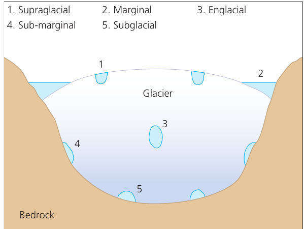
The five main types of meltwater channels are:
- Supraglacial - channels that flow on top of the glacier surface
- Marginal - channels that flow along the lateral edges where the glacier meets valley walls
- Englacial - channels that flow within the interior body of the glacier
- Sub-marginal - channels that flow at the lower lateral margins
- Subglacial - channels that flow at the base beneath the glacier
An important characteristic of sub-glacial streams is their ability to flow uphill. This occurs due to hydrostatic pressure - the weight and pressure of the overlying ice forces water through channels even against gravity.
A crucial point to understand is that only meltwater flowing in direct contact with the bedrock floor will leave any visible erosional trace in the post-glacial landscape. Water flowing within or on top of the ice leaves no permanent mark once the glacier melts.
Research suggests that beneath current glaciers, two main types of channels exist:
- Nye channels - these cut downwards into the bedrock through headward erosion, creating permanent features
- Röthlisberger channels - these cut upwards into the ice itself by meltwater. These channels become choked with sediment and leave no post-glacial trace if they fill completely
Where meltwater discharge is high and flow is particularly turbulent, these processes can create sub-glacial valleys. These valleys are often deep and contain numerous potholes (circular depressions eroded into bedrock by swirling water and debris).
Pro-glacial lakes and overflow channels
During deglaciation (when ice sheets retreat), lakes frequently develop along the edges of the ice. Some of these lakes can occupy very large areas. When these lakes overflow across the lowest points of their watersheds, they create new valleys by cutting through the landscape.
After the ice totally melts, many of these newly formed valleys are left dry. This happens because drainage patterns often revert back to their pre-glacial arrangements. However, in some cases, the post-glacial drainage system adopts these new valleys, giving rise to completely new drainage patterns.
Case study: The River Severn diversion
The River Severn is believed to have been diverted during the last glaciation, providing an excellent example of how ice can permanently alter drainage patterns.
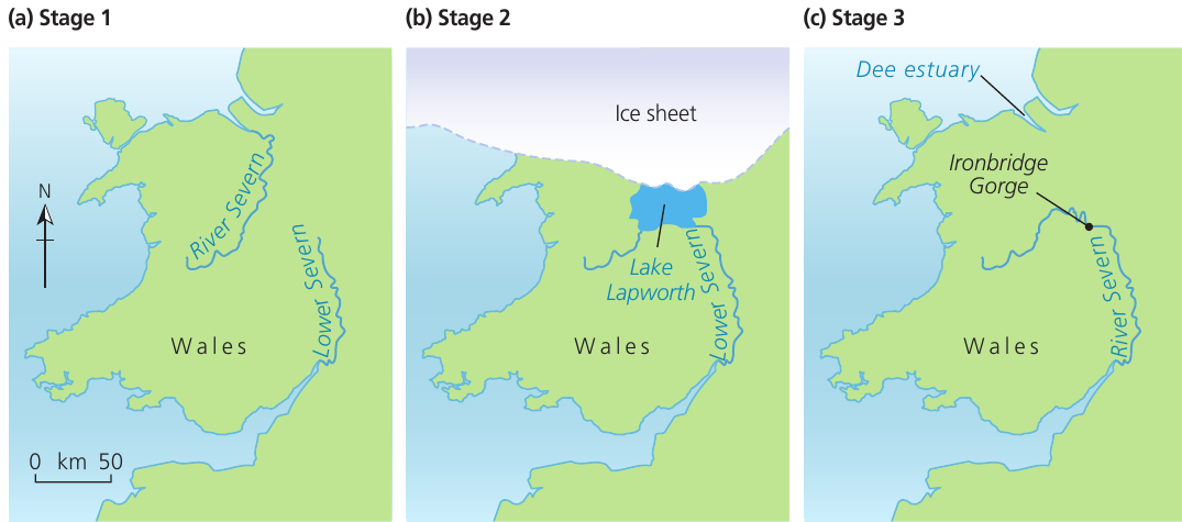
Worked Example: The River Severn Diversion Process
Stage 1 - Pre-glacial: The River Severn originally flowed northwards to enter the Irish Sea in what is now the estuary of the River Dee. The present-day Lower Severn was a much shorter river that flowed from the Welsh borderlands into the Bristol Channel.
Stage 2 - The last ice age: Ice advancing from the north blocked the River Severn valley to the north. Water from the blocked river accumulated, forming a huge pro-glacial lake known as Lake Lapworth. Eventually, this lake overflowed at the watershed to the south, joining with the original Lower Severn. During this process, the overflow cut through a solid rock area, creating the gorge at Ironbridge.
Stage 3 - The post-glacial period: As the ice retreated northwards, the way should theoretically have been left open for the two rivers to return to their pre-glacial arrangement. However, the route north was blocked by glacial deposits. Additionally, because the Ironbridge Gorge had been cut very deep (lower than the exit to the north), the new drainage system adopted this route rather than reverting to its former path. Today, the River Severn flows from central Wales to the Bristol Channel through this diverted course.
Fluvio-glacial deposition features
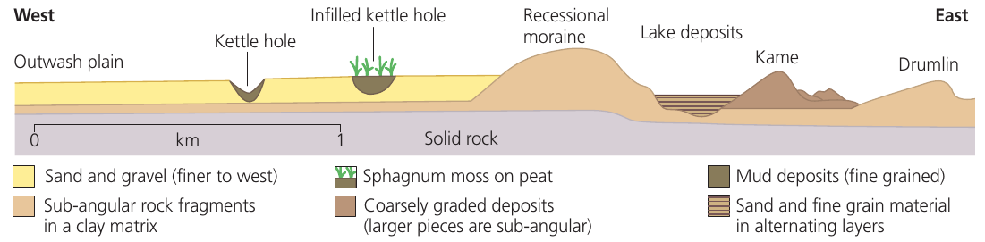
Landscapes shaped by fluvio-glacial deposition contain several distinctive features. The main landforms include eskers, kames, outwash plains (sandur), and pro-glacial lakes. Lakes on the outwash plain often contain layered deposits called varves.
Eskers
Eskers are long ridges of material that run in the direction of ice advance. They typically measure 5-20 metres in height and consist of sorted coarse material, usually coarse sands and gravel. They are often stratified (showing distinct layers).
Eskers are believed to form through deposition by sub-glacial streams. The formation process works as follows:
- The channel of the sub-glacial stream is restricted by ice walls on either side
- This restriction creates considerable hydrostatic pressure
- The hydrostatic pressure enables a large load to be carried by the stream
- The pressure also allows the stream to flow uphill for short distances
- The sediment load gradually builds up along the bed of the channel, accumulating above the surrounding land
- When the glacier retreats during deglaciation, a ridge is left behind marking the former stream channel
In some areas, esker ridges become combined with mounds of material (possibly kames). When this occurs, the feature is known as a beaded esker. Eskers are common landforms in formerly glaciated areas of Europe and North America.
Kames
Kames are mounds of fluvio-glacial material composed of sorted, coarse sands and gravel.
Kames form as deltaic deposits. They are left behind when meltwater flows into a lake that has been dammed up in front of the glacial snout by recessional moraine deposits. When the ice retreats further, the delta structure often collapses, leaving irregular mounds.
Kame terraces are a related feature frequently found along the sides of glacial valleys. These terraces represent deposits from meltwater streams that flowed between the ice and the valley side.
Outwash plains (sandur)
Outwash plains are found in front of a glacier's snout. They are deposited by meltwater streams issuing from the ice. These plains consist of material that was originally brought down by the glacier, then picked up, sorted and dropped by running water beyond the ice front.
The spatial pattern of deposition reflects the energy of the transporting water:
- The coarsest material travels the shortest distance and is therefore found nearest to the glacier
- Fine material such as clay is carried considerable distances across the plain before being deposited
The deposits are also layered vertically. This vertical stratification reflects the seasonal variations in meltwater flow - different amounts and types of sediment are deposited during different seasons.
Braided streams
Meltwater streams that cross the outwash plain often become braided. This happens because the channels become choked with coarse material due to marked seasonal variations in discharge. During periods of lower discharge, the stream lacks the energy to transport all the accumulated sediment, so it splits into multiple smaller channels that weave around the deposits.
On the outwash plain, there is often a series of small depressions filled with lakes and marshes. These are known as kettle holes. They form when blocks of ice are washed onto the plain, subsequently melt, and leave a gap in the sediments. These holes then fill with water to form small lakes. Over time, aquatic plants become established in the lakes, leading to the development of marshy areas and eventually peat.
Varves
Lakes on the fringe of the ice sheet become filled with deposits that show a distinct layering pattern. Each layer represents one year's deposition in the lake and is known as a varve.
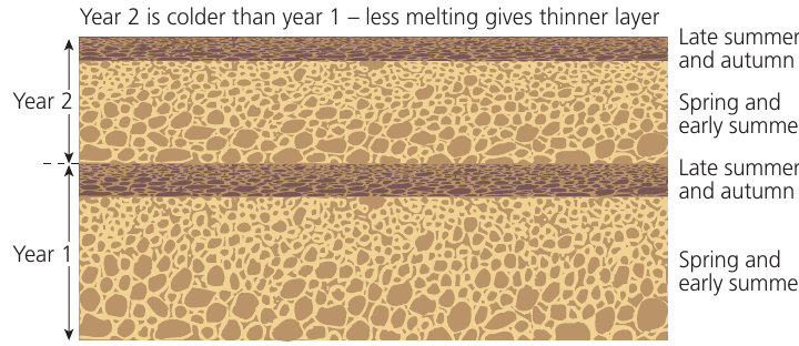
The formation of varves reflects seasonal variations in meltwater flow:
- A layer of silt lying on top of a layer of sand represents one complete year's deposition
- The coarser, lighter-coloured layer represents spring and early summer deposition, when meltwater is at its peak and streams are carrying maximum sediment load
- The thinner, darker-coloured layer of finer silt settles during autumn and through the winter, when stream discharge decreases and very little sediment is brought in. This fine material settles slowly to the bottom
Varves serve as valuable indicators in several ways:
- They are a good indicator of the age of lake sediments
- They provide evidence of past climates, as the thickness of each varve indicates warmer and colder periods
- Organic material such as seeds and pollen trapped in these layers can be used for paleoclimatic (ancient climate) research
Characteristic fluvio-glacial landscapes
The preceding sections demonstrate the significant role of meltwater in shaping landscapes. Many areas in southern Iceland, located on the edges of warm-based glaciers and ice sheets, display fluvio-glacial landscapes composed of various fluvio-glacial features and landforms. The most recognisable of these landscapes are the expansive sandur or outwash plains.
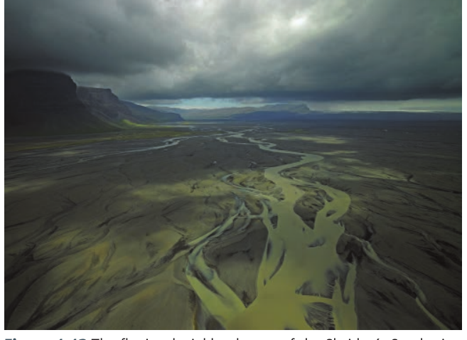
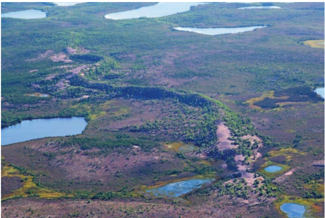
Case study: Skeidarár Sandur, southern Iceland
The Skeidarár Sandur in southern Iceland provides an excellent example of a fluvio-glacial landscape. This outwash plain extends from the Vatnajökull icecap, covering 1,300 square kilometres.
Worked Example: Skeidarár Sandur Features
It exhibits the classic features of fluvio-glacial landscapes:
-
Deep accumulations of sediment: The plain contains thick layers of black gravel, sand and silt originating from the local volcanic rock
-
Criss-crossed by braided streams: The landscape is constantly shifting with braided stream channels. Evidence of abandoned channels can be seen throughout the area, demonstrating how seasonally changing discharge levels affect rates of erosion and deposition
-
Sparse vegetation: There is very sparse vegetation and little evidence of human habitation. This results from the constant risk of floods or glacial burst (jökulhlaup) due to volcanic eruptions in the area. A major eruption occurred in 1996, with more minor events in 2004 and 2011
-
Kames and kettle holes: Close to the glacier snout, the landscape features ridges or steps that may result from kames or kettle hole features
Periglacial features
The term periglacial refers to landscapes that, although not actually glaciated, are exposed to very cold conditions. These areas experience intense frost action and develop permanently frozen ground known as permafrost. Some geographers apply the term more narrowly, using it only for areas affected by freeze-thaw cycles in close proximity to ice sheets.
At present, periglacial areas include the tundra landscapes of northern Russia, Alaska and northern Canada. Additionally, high mountainous areas such as the European Alps experience a periglacial climate. However, in the past, as ice sheets and glaciers spread during glacial periods, many areas which are currently temperate were subject to periglacial conditions.
Periglacial climate
The climate of periglacial regions is characterised by several distinct features:
-
Persistently low temperatures: Annual average temperatures range between -15°C and -1°C
-
Moderate precipitation: Average annual rainfall (excluding snowfall) ranges between approximately 120 mm and 1,400 mm
-
Short summers: Temperatures can sometimes reach above 15°C during summer months, but remain well below freezing in winter, with some areas occasionally reaching -50°C
Permafrost
Permafrost refers to permanently frozen ground. It occurs in areas where temperatures below the ground surface remain below 0°C continuously for more than two years.
Currently, it is estimated that permafrost covers 20-25 per cent of the Earth's land surface. When water is present in the soil, it freezes, cementing the mineral and organic particles together. The ground below this frozen layer (known as talik) remains unfrozen.
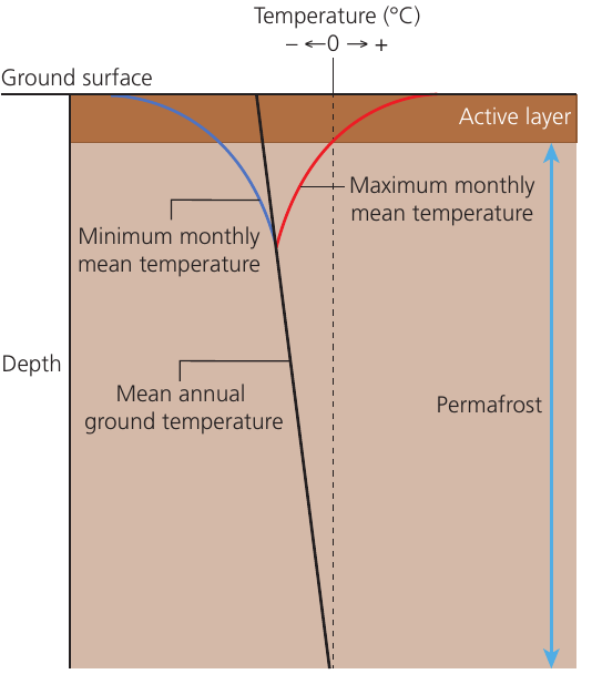
Active layer
When summer temperatures rise above freezing, the surface layer thaws. This thawing occurs from the surface downwards, forming what is known as an active layer. The depth of this layer varies considerably and depends upon local conditions, but it may extend to 4 metres. As the ice in this layer melts, large volumes of water are released into the environment.
The active layer is critical to periglacial environments because it's the only part of the ground that experiences seasonal thawing. This zone is where most biological activity occurs and where plants can establish roots. The release of large volumes of meltwater from the active layer during summer significantly influences local drainage patterns and can contribute to landscape instability.
Key Points to Remember:
-
Meltwater is powerful: Glacial meltwater flows under high pressure, giving it the ability to transport large sediment loads and even flow uphill in sub-glacial channels due to hydrostatic pressure.
-
Deposition creates distinctive landforms: Key fluvio-glacial deposition features include eskers (long ridges), kames (mounds), outwash plains (sandur), and varves (annual layers in lakes). Each tells us something about how meltwater behaved.
-
Sorting and stratification are key characteristics: Fluvio-glacial deposits are sorted (heaviest material deposited first, nearest the ice) and stratified (showing layers from seasonal variations in meltwater flow).
-
Overflow channels can permanently alter drainage: Pro-glacial lakes that form at ice margins can overflow and cut new valleys, sometimes permanently diverting river systems (as seen with the River Severn).
-
Periglacial ≠ glacial: Periglacial regions are not covered by ice but experience extremely cold conditions that lead to permafrost development. The active layer thaws seasonally, releasing large volumes of water.