Drainage Basin Systems (AQA A-Level Geography): Revision Notes
Drainage Basin Systems
Introduction to drainage basins
A drainage basin (sometimes called a catchment area) represents the land area that channels water to a specific river and its tributaries. Think of it as nature's water collection system - everything from surface water to groundwater within the basin eventually makes its way to the main river channel.
The boundary separating one drainage basin from another is marked by high ground called a watershed. Below ground, the system extends to include water stored in soils and rocks beneath the surface.
An effective way to understand drainage basins is to view them as cascading systems. This means they function as a series of connected open systems, where the output from one component becomes the input for the next. This interconnected nature makes drainage basins dynamic and responsive to changes.
System components
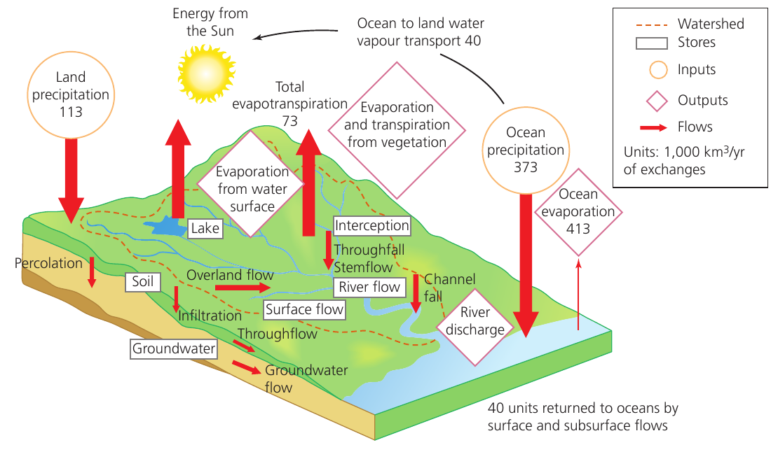
Inputs, stores, transfers and outputs
Like all natural systems, drainage basins can be broken down into four main components that help us understand how water moves through the landscape:
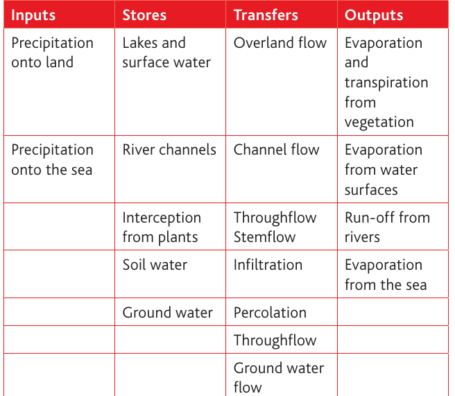
Inputs represent water entering the system. The primary input is precipitation falling onto the land surface. The characteristics of this precipitation - its intensity, duration and form (rain, snow, hail) - significantly influence what happens next in the system.
Stores are locations where water is held temporarily within the drainage basin. These include:
- Lakes and surface water bodies
- River channels themselves
- Interception storage on vegetation
- Soil water held in pore spaces
- Groundwater stored in rocks below the surface
Transfers describe the various pathways water takes as it moves through the system. These processes include overland flow across the surface, throughflow moving laterally through soil, and percolation descending through rocks.
Outputs represent water leaving the drainage basin. The main outputs are evaporation from water surfaces, transpiration from vegetation (often combined as evapotranspiration), and run-off where water exits via the river channel.
Understanding these components allows us to track water movement and predict how drainage basins respond to different conditions.
How water moves through the drainage basin
The journey from precipitation to river
When precipitation falls onto a hillside, several processes determine its path to the river channel. The nature and speed of this journey depend on factors including rainfall intensity, vegetation cover, soil type and slope gradient.
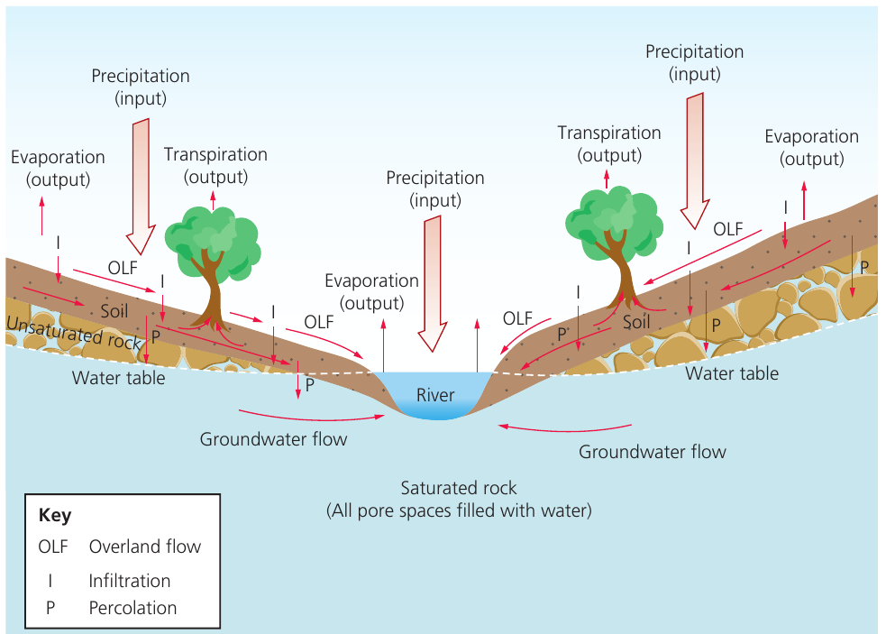
Interception - the first barrier
Interception store refers to precipitation that lands on vegetation surfaces (leaves, branches, stems) or human-made structures rather than directly reaching the ground. This water is temporarily held on these surfaces.
Not all vegetation intercepts water equally effectively. Research shows that forests composed of needle-leaf trees capture approximately 22% of rainfall, whilst broad-leaf deciduous forests intercept around 19%. This difference likely relates to the overall density of the vegetation canopy rather than individual leaf structure. Some tropical rainforests can intercept as much as 58% of total rainfall.
Water held in the interception store has three possible fates:
- Direct evaporation back to the atmosphere
- Absorption into the plant structure
- Transfer to the ground through throughfall or stemflow
Throughfall occurs when water drips from leaves, twigs and stems, or falls directly through gaps in the vegetation canopy. This happens when the storage capacity of the vegetation surface is exceeded.
Stemflow describes precipitation that flows down plant stems, stalks or tree trunks after being intercepted by the canopy above.
Infiltration - entering the soil
Once water reaches the ground surface (whether directly or via throughfall and stemflow), it begins to soak into the soil through a process called infiltration.
Infiltration is the downward movement of water from the surface into the soil. The rate at which this occurs is called the infiltration rate.
The infiltration rate controls how much water enters the soil versus flowing across the surface. This rate depends on several factors, with soil porosity being most critical. A soil's porosity is determined by its texture, structure and organic content:
- Coarse-textured soils (sandy soils) have larger pores and fissures, allowing water to pass through quickly
- Fine-grained soils (clay soils) have smaller pores that restrict water movement
Interestingly, soil structure can be enhanced naturally. The burrowing activities of worms and other organisms, along with plant root penetration, create additional macro- and micro-channels that improve water flow through the soil.
How infiltration rates change during rainfall:
The infiltration rate typically declines rapidly during the early stages of a rainstorm, then stabilises after several hours. Three main processes cause this decline:
- Small pores at the soil surface fill with water, reducing capillary forces that normally draw water into the soil
- Clay particles absorb water and expand, decreasing the size of existing pores
- Raindrop impact breaks apart larger soil clumps, creating smaller particles that clog surface pores and restrict water movement
When infiltration capacity is exceeded
Infiltration capacity represents the maximum rate at which soil can absorb water under given conditions.
If rainfall intensity exceeds the infiltration capacity, water cannot enter the soil quickly enough and begins to accumulate on the surface as surface storage. This commonly occurs after prolonged rainfall when soils become saturated. The soil is considered saturated when all available pore spaces are filled with water.

On natural surfaces, this surface water typically disappears into the ground relatively quickly. However, on impermeable surfaces (concrete pavements, tarmac roads, bare rock, frozen ground), water has nowhere to infiltrate and must flow across the surface.
Overland flow (also called sheet flow) occurs when water flows horizontally across land surfaces because rainfall has exceeded infiltration capacity and all surface stores are full and overflowing.
This represents very rapid water movement with few obstacles slowing the flow. Urban areas experience particularly fast overland flow because surfaces are often designed with strategic slopes and smooth finishes to move water quickly. In contrast, water moves through soil much more slowly.
Lateral movement through soil - throughflow
Even whilst water is infiltrating, lateral movement may begin.
Throughflow describes the movement of water downslope through the subsoil, influenced by gravity. It tends to be particularly effective when permeable rock layers underlie the soil, preventing further downward movement.
This lateral water movement eventually reaches the nearest channel, though it travels considerably more slowly than overland flow. The rate of throughflow increases in vegetated areas because plants constantly extract water from the soil for transpiration. This process, known as vegetation storage, involves plants removing water from the soil and temporarily storing it in their structure before releasing it to the atmosphere through stomata on their leaves.
Transpiration is the loss of water from vegetation through microscopic pores (stomata) on leaf surfaces.
Downward movement - percolation and groundwater
Following infiltration, water continues moving vertically downward through the soil and underlying rock.
Percolation refers to the downward movement of water through rock layers beneath the soil surface. The rate varies considerably depending on rock characteristics.
Water first travels through unsaturated rock, where pore spaces may be held in the rocks as groundwater. From here, it moves very slowly both vertically and laterally.
Groundwater flow describes the slow movement of water through underlying rock layers. This is extremely gradual movement that can span long periods of drought.
Some rocks can store substantial amounts of water, particularly if they are porous. These water-bearing rocks are called aquifers.
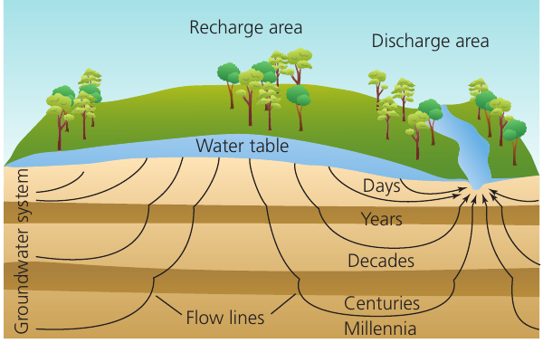
The time water spends moving through different parts of the system varies enormously, from seconds or minutes for overland flow to potentially millennia for deep groundwater flow.

Water reaching the river channel
All these various flows and transfers eventually deliver water to the nearest river or lake (or to deep groundwater storage). The river then transports water through channel flow, which represents the amount of water exiting the drainage basin.
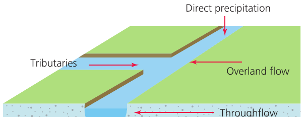
The main sources of water feeding into a stream or river include:
- Direct precipitation falling onto the water surface
- Tributary streams joining the main channel
- Overland flow from surrounding land
- Throughflow emerging at the channel edge
- Groundwater discharge where the water table intersects the river bed
Run-off encompasses all water that enters a river channel and eventually flows out of the drainage basin.
Water balance in drainage basins
The concept of water balance helps us understand the relationship between water entering and leaving a drainage basin over time.
Water balance represents the equilibrium between inputs (precipitation) and outputs (run-off, evapotranspiration, and changes in soil and groundwater storage) within a drainage basin.
This balance can be expressed mathematically as:
Where:
- = Precipitation (input)
- = Discharge (river flow/run-off)
- = Evapotranspiration (output to atmosphere)
- = Change in storage (soil moisture and groundwater)
The two most critical components of this relationship are precipitation and potential evapotranspiration.
Potential evapotranspiration represents the amount of water that could be evaporated or transpired from an area if sufficient water was available.
Potential evapotranspiration closely relates to prevailing temperature. Higher temperatures increase evapotranspiration rates because the warmer atmosphere can hold more water vapour. Sometimes the atmosphere's capacity to hold water vapour exceeds the actual water available for evaporation, creating a deficit.
Seasonal variations in water balance
Rivers typically exhibit an annual pattern of discharge levels called the river's regime. However, discharge also fluctuates in the short term following heavy rainfall events.
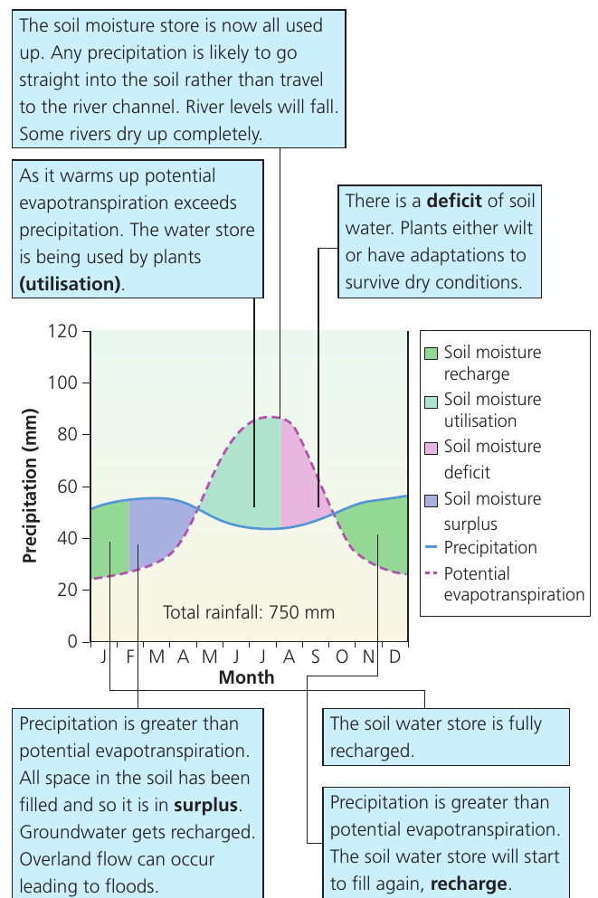
The soil moisture budget graph illustrates how precipitation and potential evapotranspiration interact throughout the year. Consider an area in eastern England with 750mm annual rainfall:
Seasonal Water Balance Changes: Eastern England
Autumn and winter (recharge period):
- Precipitation exceeds potential evapotranspiration
- Soil water stores fill rapidly
- Once soil is full, water becomes surplus
- Surplus water recharges groundwater stores
- Overland flow may occur, potentially causing flooding
Spring (utilisation period):
- Warming temperatures increase potential evapotranspiration
- This begins to exceed precipitation
- Plants actively extract water from soil (utilisation)
- Soil water stores gradually decline
- River levels start to fall
Summer (deficit period):
- Potential evapotranspiration significantly exceeds precipitation
- All soil water stores become depleted
- A deficit of soil water develops
- Plants experience water stress and may wilt
- Some rivers may dry up completely without adaptations to survive dry conditions
Late summer/autumn (recharge begins):
- Temperatures cool, reducing evapotranspiration
- Any precipitation begins replenishing soil stores
- Soil water store starts to recharge ready for winter
- River levels begin recovering
Different climates produce markedly different soil moisture patterns. Equatorial regions with consistent high rainfall and year-round warm temperatures maintain relatively stable conditions, though potential evapotranspiration remains fairly constant throughout the year.
Remember!
Key Points to Remember:
-
Drainage basins function as cascading open systems where water flows between interconnected components (inputs, stores, transfers and outputs)
-
Vegetation plays a crucial role by intercepting precipitation, storing water temporarily, and returning it to the atmosphere through transpiration
-
The infiltration rate determines whether water enters the soil or flows across the surface - this rate depends primarily on soil porosity and decreases during prolonged rainfall
-
Water moves through drainage basins at vastly different speeds, from rapid overland flow (minutes) to extremely slow groundwater flow (potentially thousands of years)
-
The water balance equation () helps predict seasonal variations in river discharge and soil moisture availability, with distinct recharge, utilisation, deficit and surplus periods throughout the year