Erosional landforms 2 (Edexcel GCSE Geography A): Revision Notes
Erosional landforms 2
Introduction
Various landforms are created through erosion in glaciated upland landscapes, particularly within valley systems. The key features you need to understand include truncated spurs, glacial troughs, and hanging valleys. These distinctive landforms provide clear evidence of past glacial activity and demonstrate how ice can dramatically reshape the landscape.
These erosional landforms are essential indicators for identifying areas that have experienced glaciation in the past. Understanding their formation processes helps explain how glaciers transform entire landscape systems.
Glacial troughs
Glacial troughs represent one of the most recognisable features of glaciated landscapes. These impressive valleys have a characteristic U-shaped profile that makes them easy to identify both in the field and on Ordnance Survey maps.

Formation and characteristics
A glacial trough develops when a glacier occupies and modifies an existing river valley. The original V-shaped river valley, created by water erosion, undergoes dramatic transformation through glacial processes. The glacier widens and deepens the valley floor whilst steepening the valley sides, ultimately creating the distinctive U-shaped cross-section.
The formation process involves two main erosional mechanisms. Abrasion occurs when rock debris frozen into the glacier base acts like sandpaper, grinding away the valley floor and sides. Plucking happens when the glacier freezes to bedrock and pulls away loose rock as it moves forwards. These processes work together to carve out the characteristic steep sides and flat floor of the glacial trough.
The key difference between river valleys (V-shaped) and glacial troughs (U-shaped) lies in their cross-sectional profiles. This distinction is crucial for identifying past glacial activity in landscapes.
Recognition on maps
On Ordnance Survey maps, glacial troughs appear as valleys with widely spaced contour lines indicating steep valley sides, combined with a flat valley floor shown by the absence of contour lines across the valley bottom. This distinctive pattern makes them easily distinguishable from V-shaped river valleys, which show closely packed contours forming a V-pattern.
Truncated spurs
Before glaciation, river valleys typically feature interlocking spurs - ridges of high land that project alternately from either side of the valley, creating a winding valley pattern. When glaciers advance down these valleys, they cannot navigate around these obstacles like rivers do.
Formation process
Truncated spurs form when glaciers erode and remove the lower portions of interlocking spurs. The glacier's immense erosive power, combined with the rock debris it carries (moraine), literally cuts through these landscape features. This process leaves behind steep-sided cliff faces where the spurs have been 'truncated' or cut off.
The result is a much straighter valley profile compared to the original meandering river valley. These truncated spurs often appear as prominent cliff faces or steep rocky outcrops along the sides of glacial troughs.
The straight valley profile created by truncated spurs contrasts dramatically with the winding pattern of pre-glacial river valleys, providing clear evidence of glacial modification.
Hanging valleys
Hanging valleys represent another distinctive feature of glaciated landscapes, often creating some of the most spectacular waterfalls in mountainous regions.
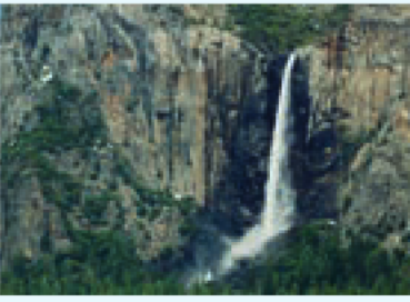
Formation and characteristics
Hanging valleys develop due to the different rates of erosion between main glaciers and their tributaries. The main glacier, being much larger and more powerful, erodes its valley much more deeply than the smaller tributary glaciers can erode theirs. This creates a significant height difference between the floors of the main valley and the tributary valleys.
When the ice retreats, the tributary valleys are left 'hanging' high above the main glacial trough. Streams flowing down these hanging valleys often plunge dramatically into the main valley, creating impressive waterfalls. These waterfalls serve as clear indicators of former glacial activity and help geographers identify areas that have experienced glaciation.
Waterfalls cascading from hanging valleys are one of the most reliable indicators of past glacial activity. The greater the height difference, the more powerful the former glacier was.
Valley transformation
The process demonstrates the dramatic difference in erosive power between different sized glaciers. While tributary glaciers create relatively shallow troughs, the main glacier carves a deep, wide valley. This differential erosion is what creates the stepped profile characteristic of glaciated mountain landscapes.
Ribbon lakes
Within glacial troughs, long narrow lakes known as ribbon lakes frequently develop. These lakes form in the over-deepened sections of the trough floor, often where the glacier's erosive power was particularly concentrated. The lakes typically stretch along the valley floor, following the line of the former glacier's path.
These water bodies add to the distinctive appearance of glaciated valleys and provide further evidence of past ice activity. They often enhance the scenic beauty of these landscapes and can be important water resources for local communities.
Ribbon lakes often form where glaciers encountered particularly resistant bedrock or where confluences of ice streams created enhanced erosive power, resulting in over-deepening of the valley floor.
Key Points to Remember:
- Glacial troughs are U-shaped valleys with steep sides and flat floors, easily recognised on OS maps by their distinctive contour patterns
- Truncated spurs form when glaciers cut through interlocking spurs, creating straight valley profiles with steep cliff faces
- Hanging valleys occur when tributary glaciers erode less deeply than main glaciers, leaving side valleys suspended above the main trough
- Waterfalls cascading from hanging valleys provide clear evidence of past glacial activity
- These landforms work together to create the dramatic stepped profile characteristic of glaciated mountain landscapes