Rainfall (Leaving Cert Geography): Revision Notes
Rainfall
What is precipitation?
Precipitation is defined as any form of water that falls from the atmosphere to Earth's surface, whether in liquid or solid form. This includes four main types:
- Rainfall - Liquid water droplets that fall when air temperature stays above freezing point. This represents the most common type of precipitation.
- Snow - Ice crystals that form when air temperature drops below freezing point. Snow can build up to create beautiful winter landscapes.
- Sleet - Small ice pellets that develop when raindrops freeze during their journey to the ground. This often creates dangerous driving conditions.
- Hail - Larger frozen ice pellets that form during intense thunderstorms and can cause significant damage.
Precipitation happens when moist air cools down and reaches condensation point. The tiny water droplets or ice crystals then combine and grow heavy enough to fall towards the ground.
The formation of precipitation is a continuous cycle that depends on temperature, atmospheric pressure, and moisture content in the air. Understanding these basic principles helps explain why different types of precipitation occur under various weather conditions.
How rainfall occurs
Rainfall develops when warm, moist air rises into the atmosphere and begins to cool down. As this air reaches its dew point (the temperature where it cannot hold any more moisture), water vapour transforms into tiny water droplets that create clouds. When these droplets combine and become sufficiently heavy, they fall as rainfall.
There are three main mechanisms that cause rainfall:
- Relief rainfall
- Frontal rainfall
- Convectional rainfall
The dew point is a critical concept in meteorology - it's the exact temperature at which air becomes saturated with water vapour and condensation begins. This determines when and where clouds will form.
Relief rainfall
Relief rainfall, sometimes called orographic rainfall, takes place in mountainous areas and significantly influences local climate patterns. This process occurs through four distinct stages:
Stage 1: Moist air meets mountains When humid air from seas or oceans encounters a mountain range, it must rise up and over the barrier. As this air ascends, atmospheric pressure decreases with altitude, causing the air to cool.
Stage 2: Condensation and cloud formation The rising air continues cooling until it reaches its dew point. At this critical temperature, water vapour condenses into tiny droplets, forming clouds on the mountain slopes.
Stage 3: Rainfall on the windward side The moisture-laden air keeps rising over the mountain, and clouds grow thicker. Eventually, water droplets combine and become heavy enough to fall as rainfall on the windward side (the side facing the prevailing wind).
Stage 4: Rain shadow effect
After crossing the mountain peak, the now-dry air descends on the leeward side (sheltered from the wind). This descending air warms up and dries out, preventing rainfall formation. This creates a rain shadow - an area that experiences arid or semi-arid conditions.
Real-world Examples of Relief Rainfall:
The Western Ghats, India: The windward side facing the Arabian Sea experiences lush forests and high precipitation during monsoon season, whilst the leeward Deccan Plateau remains much drier.
The Andes Mountains, South America: The Amazon Rainforest benefits from relief rainfall on the eastern windward side, whilst the western leeward side, including parts of Chile, remains arid.
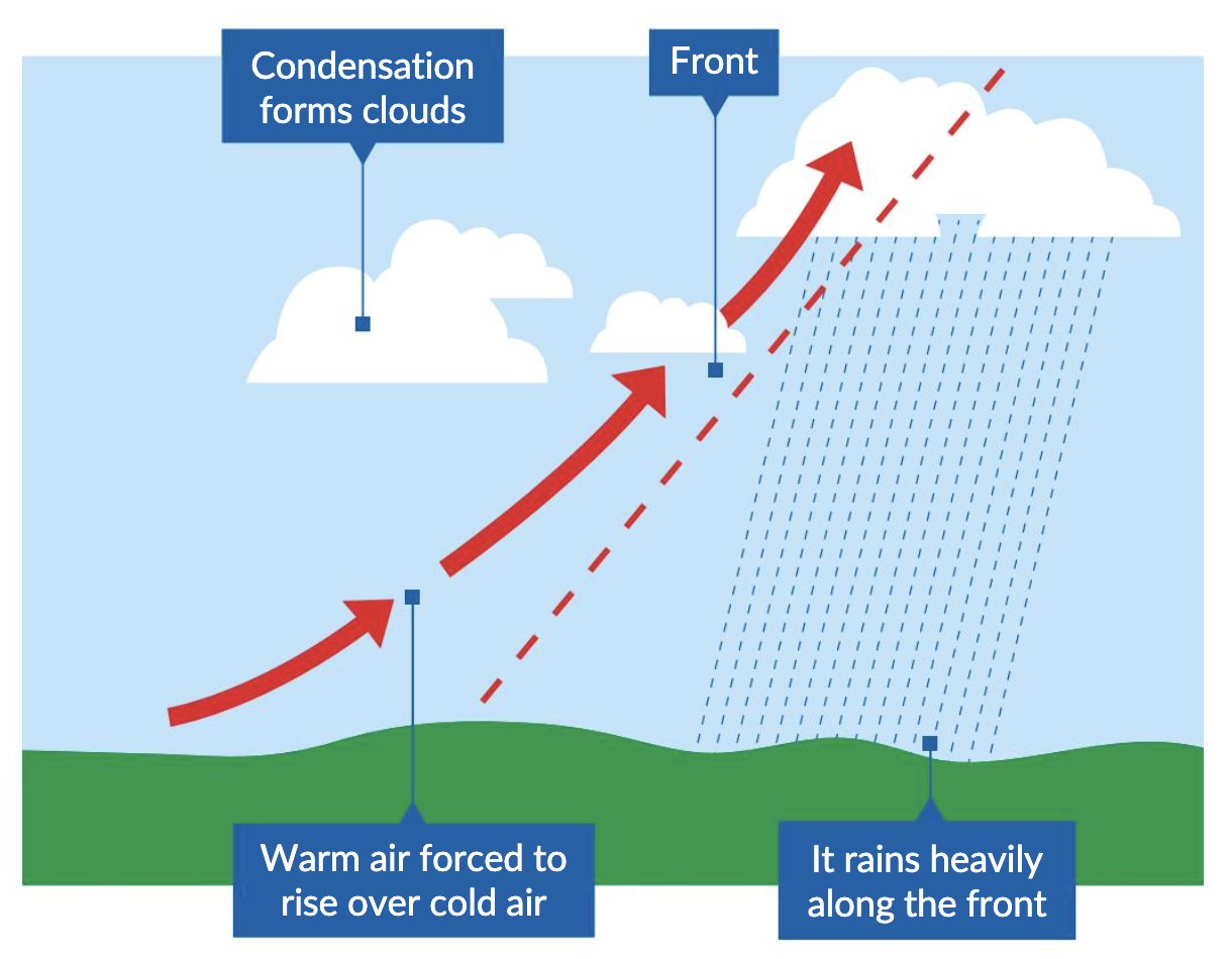
Frontal rainfall
Frontal rainfall, also known as cyclonic rainfall, accounts for a substantial portion of precipitation in temperate regions like Ireland. This weather phenomenon occurs when two different air masses collide.
The formation process:
Stage 1: Collision of air masses A warm air mass meets a cold air mass. Since warm air has lower density, it rises above the denser, heavier cold air. This collision typically happens in areas with varying atmospheric pressure.
Stage 2: Formation of a weather front As warm air rises and cools, moisture condenses to form clouds. This process creates a weather front - the boundary zone between warm and cold air masses.
Stage 3: Rainfall along the front
Along this front, rising warm air continues cooling, leading to raindrop formation. These raindrops fall as precipitation, often covering extended areas depending on the front's size and movement
Types of weather fronts
Warm fronts Develop when a warm air mass advances over a retreating cold air mass. These fronts typically bring steady, light to moderate rainfall with gentle slopes. They often create cloudy, overcast conditions that can last for several hours.
Cold fronts Form when a cold air mass pushes underneath a warm air mass, forcing rapid upward movement of warm air. Cold fronts produce more intense but shorter-lived rainfall, frequently accompanied by thunderstorms and heavy downpours.
Occluded fronts Create complex weather patterns when a cold front catches up with a warm front, lifting the warm air mass completely off the ground. This interaction results in mixed precipitation types including rain, sleet, or snow, depending on temperature conditions.
Ireland frequently experiences frontal rainfall due to its position in the path of Atlantic weather systems. When warm, moist air masses from the ocean collide with cold air masses, this produces the characteristic changeable weather of the Irish climate.
Convectional rainfall
Convectional rainfall plays a vital role in weather systems, particularly contributing to short but intense rainfall bursts during summer months. Understanding this process helps explain sudden thunderstorms and heavy downpours.
The convectional process:
Stage 1: Ground surface heating Convectional rainfall begins when the sun heats Earth's surface during daylight hours. This heating effect becomes most pronounced in summer when solar radiation is more direct and intense.
Stage 2: Air warming and rising As the ground heats up, it warms the air directly above it. Warm air becomes lighter and less dense than surrounding cold air, causing it to rise rapidly. This rising warm air creates what meteorologists call an updraught.
Stage 3: Cooling and condensation The ascending warm air encounters cooler temperatures at higher altitudes. As it rises and cools, the air eventually reaches a point where moisture condenses to form distinctive cumulonimbus clouds - tall, towering cloud formations.
Stage 4: Heavy rainfall
These impressive cumulonimbus clouds become associated with heavy rainfall and often thunderstorms. The condensed moisture within clouds combines to form raindrops that fall to the ground as intense precipitation.
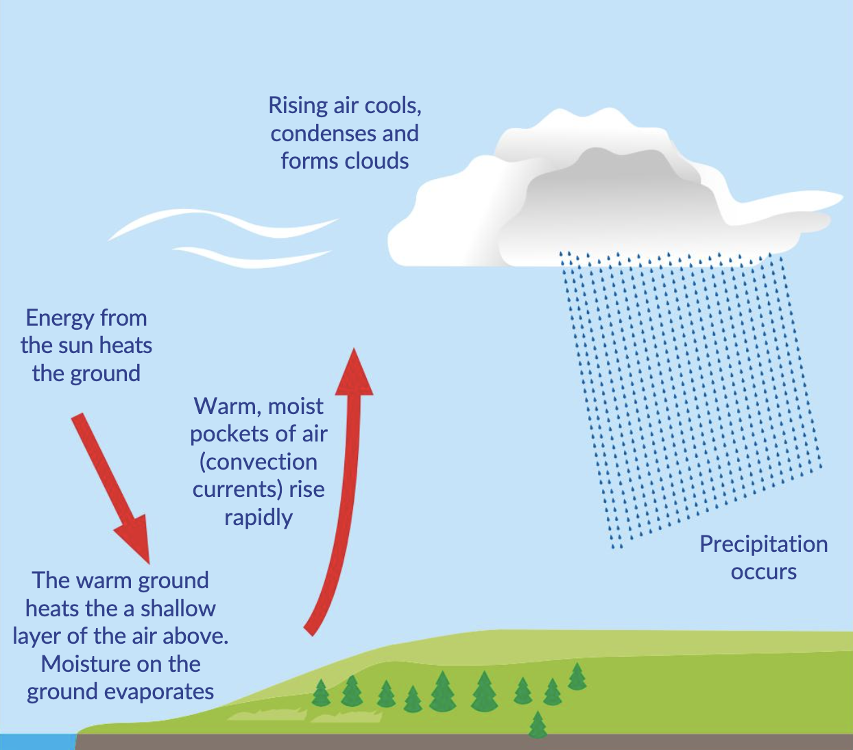
Cumulonimbus clouds are the giants of the cloud world, often reaching heights of 12-18 kilometres. These towering formations are responsible for the most dramatic weather events, including thunderstorms, heavy rainfall, and sometimes tornadoes.
Convectional rainfall commonly occurs in the eastern and central areas of Ireland, especially during summer when solar heating reaches peak intensity. After hot, sunny days, rising warm air can lead to cumulonimbus cloud development, resulting in heavy and sometimes thunderous rainfall that provides relief from heat.
Key Points to Remember:
-
Precipitation includes four forms: rain, snow, sleet, and hail - all water falling from the atmosphere to Earth's surface.
-
Three rainfall types exist: Relief rainfall occurs in mountains creating rain shadows; frontal rainfall happens when different air masses meet; convectional rainfall develops from ground heating and rising air.
-
Relief rainfall creates contrasts: The windward side of mountains receives heavy precipitation whilst the leeward side experiences dry, arid conditions due to the rain shadow effect.
-
Frontal systems vary: Warm fronts bring steady, prolonged rainfall; cold fronts produce intense, short-lived downpours; occluded fronts create mixed precipitation types.
-
Convectional rainfall brings intensity: Summer heating creates updrafts that form towering cumulonimbus clouds, leading to heavy rainfall and thunderstorms, particularly common in Ireland's interior regions.