Types of Clouds (Leaving Cert Geography): Revision Notes
Types of clouds
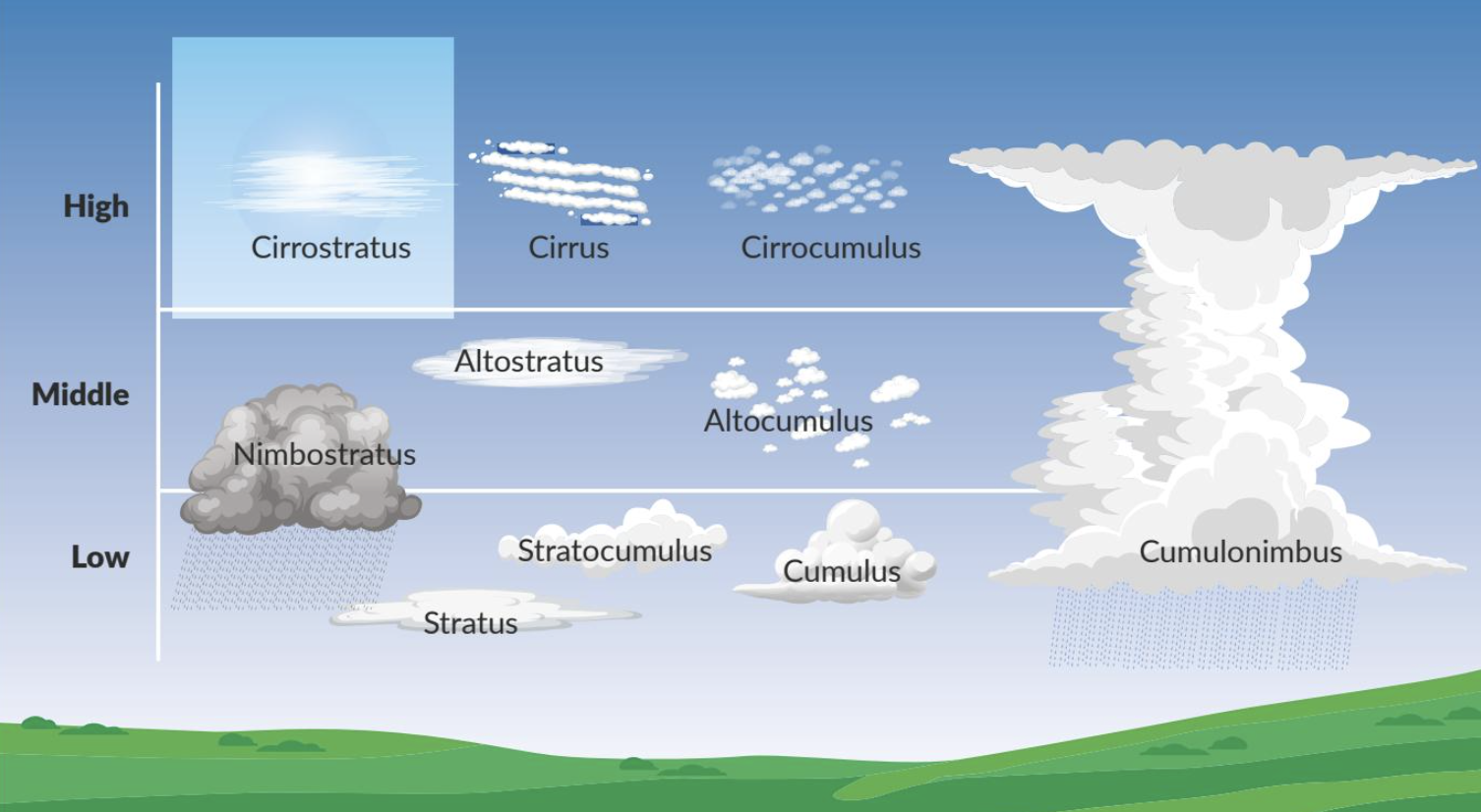
Cloud classification overview
Clouds form in different shapes and sizes throughout Earth's atmosphere. Scientists classify clouds into four main types based on their altitude and appearance:
- Cirrus - high-altitude clouds
- Altocumulus - mid-level clouds
- Nimbostratus - low-level clouds
- Cumulonimbus - vertical development clouds
Understanding these cloud types helps predict weather patterns and atmospheric conditions, making cloud identification a valuable skill for meteorologists and weather enthusiasts alike.
Cloud classification systems allow meteorologists to communicate weather conditions accurately and make reliable forecasts. The altitude-based system we use today was developed by Luke Howard in 1803 and remains the foundation of modern cloud science.
Cirrus clouds
Cirrus clouds form in the highest parts of Earth's atmosphere, typically between 6,000 and 12,000 metres above sea level. This extreme altitude gives them the nickname "high-level clouds."
These clouds have a distinctive wispy, feathery appearance. They look like thin white streaks or tufts across the sky, often resembling strands of hair or horses' tails stretching across the blue background.
Cirrus clouds consist entirely of ice crystals due to the extremely cold temperatures at high altitudes. They form through a fascinating process involving supercooled water. At their high altitude, air temperatures drop well below freezing point. However, water droplets within the clouds can remain in a supercooled state, staying liquid even at sub-zero temperatures.
Supercooled water is a remarkable phenomenon where water remains liquid below its normal freezing point. This occurs because pure water needs a nucleation point (like dust or ice crystals) to begin the freezing process. Without these nuclei, water can remain liquid at temperatures as low as -40°C.
These clouds develop around tiny condensation nuclei such as ice crystals or dust particles. Water droplets freeze onto these nuclei, gradually building up the wispy ice crystal structures we observe from the ground.
Altocumulus clouds
Altocumulus clouds occupy the middle layer of the atmosphere, forming at altitudes between 2,000 and 6,000 metres above sea level. The prefix "alto" comes from Latin meaning "middle," reflecting their position between low and high-level clouds.
These clouds appear as puffy, rounded masses or layers across the sky. They often look like small cotton balls or flakes arranged in a patchwork pattern, creating distinctive patches of cloud cover with gaps of blue sky between them.
Altocumulus clouds contain primarily water droplets, though they may also include some ice crystals depending on temperature conditions. They form when moist, warm air rises and cools as it reaches the middle levels of the atmosphere. This cooling process causes water vapour to condense into visible cloud droplets.
The specific patterns altocumulus clouds create can serve as natural weather indicators. Scattered individual clouds suggest stable atmospheric conditions, while continuous layers may signal approaching weather changes or frontal systems.

Nimbostratus clouds
Nimbostratus clouds stay close to Earth's surface, typically forming below 2,000 metres altitude in the lower atmosphere. They hang low in the sky and often cover it completely.
These clouds create a distinctive dull, grey, featureless appearance. They form thick, overcast layers that block out the sun and cast a gloomy atmosphere over the landscape below. The uniform grey coverage eliminates shadows and creates flat lighting conditions.
Nimbostratus clouds develop when moist, warm air rises over large areas, particularly along warm and cold weather fronts. As this warm, moist air rises and cools, it condenses into a continuous layer of cloud cover. The Latin term "nimbo" indicates their potential to bring precipitation, as these clouds often produce light rain or drizzle.
Nimbostratus clouds are reliable indicators of prolonged, steady precipitation. Unlike other cloud types that may produce brief showers, nimbostratus typically brings continuous light rain or drizzle that can last for hours or even days.
Cumulonimbus clouds
Cumulonimbus clouds stand out for their impressive vertical development, extending from low altitudes up to 15,000 metres or higher into the sky. They tower above other cloud types, reaching extreme heights that can penetrate the stratosphere.
These clouds have a distinctive anvil or mushroom shape structure. They feature a dark, dense base spreading horizontally near ground level, topped by an icy, spreading upper section that flattens out at high altitude, creating the characteristic anvil appearance.
Cumulonimbus clouds form through intense vertical air currents, often linked with thunderstorm activity. Warm, moist air rises rapidly and cools dramatically as it ascends. This vigorous process condenses water vapour into towering columns of cloud. The powerful updrafts carry water droplets to great heights where they freeze, creating the icy top section of the cloud structure.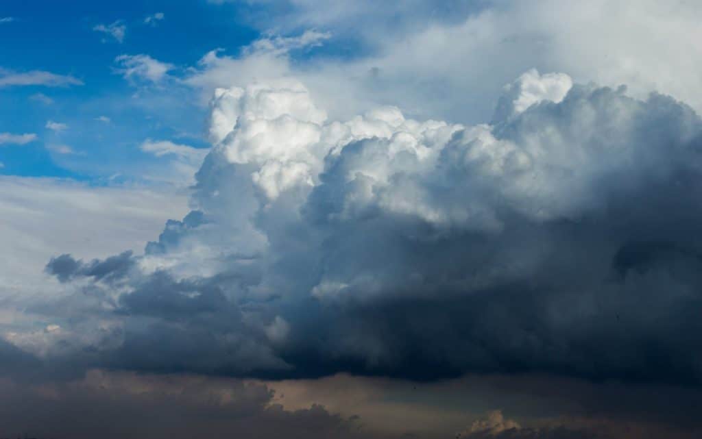
Severe Weather Warning: Cumulonimbus clouds are strongly associated with dangerous weather phenomena including thunderstorms, heavy rainfall, lightning, hail, and sometimes tornadoes. These clouds should be treated with caution as they can produce rapidly changing and potentially hazardous conditions.
Formation Process: Cumulonimbus Development
Step 1: Initial heating - Strong surface heating creates warm, moist air near the ground
Step 2: Rapid ascent - This warm air rises quickly due to convection, creating powerful updrafts
Step 3: Cooling and condensation - As the air rises, it cools rapidly, causing water vapour to condense into droplets
Step 4: Vertical growth - Continued updrafts carry the cloud higher, sometimes reaching 15,000+ metres
Step 5: Anvil formation - At the tropopause, the cloud spreads horizontally, creating the characteristic anvil shape
Key Points to Remember:
- Four main cloud types: Cirrus (high), Altocumulus (middle), Nimbostratus (low), and Cumulonimbus (vertical)
- Altitude determines classification: High clouds (6,000-12,000m), mid-level (2,000-6,000m), low (below 2,000m)
- Composition varies with temperature: High clouds contain ice crystals, lower clouds contain water droplets
- Appearance indicates weather: Wispy cirrus suggest fair weather, grey nimbostratus brings precipitation, towering cumulonimbus signals storms
- Formation involves cooling: All clouds form when rising air cools and water vapour condenses around nuclei