Prevailing Surface Winds (Leaving Cert Geography): Revision Notes
Prevailing surface winds
What are prevailing surface winds?
Prevailing surface winds are consistent wind patterns that occur regularly at specific latitudes across the Earth. These wind systems play a fundamental role in shaping global climate patterns, weather systems, and have historically been essential for ocean navigation.
The Earth's surface winds are created by the uneven heating of our planet's surface, which generates pressure differences that drive air movement. These winds are organised into three main circulation cells that work together to distribute heat from the equator towards the poles.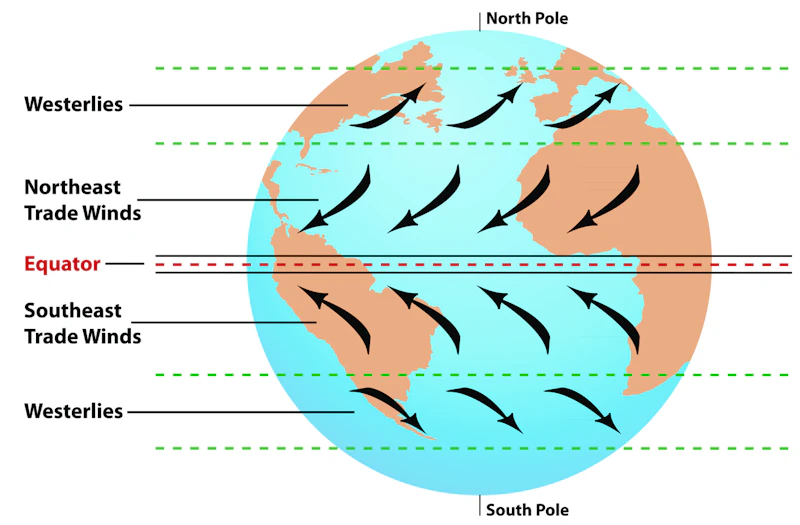
These three circulation cells - the Hadley cell, Ferrel cell, and Polar cell - form an interconnected global system that maintains Earth's heat balance and creates predictable wind patterns across different latitudes.
The three main wind systems
Trade winds
Trade winds are reliable easterly winds that flow consistently in the tropical regions between 30°N and 30°S latitude. These winds originate from subtropical high-pressure zones and move towards the equatorial low-pressure area known as the Intertropical Convergence Zone (ITCZ).
The Coriolis effect, caused by Earth's rotation, deflects these winds so they blow from the northeast in the Northern Hemisphere and from the southeast in the Southern Hemisphere. This deflexion is crucial for understanding global wind patterns.
This consistent pattern made trade winds invaluable for early maritime trade routes, as ships could rely on these steady winds to cross oceans efficiently.
Trade winds have significant climatic effects. They contribute to the high rainfall experienced by tropical rainforests like the Amazon, as they carry moisture-laden air inland. Conversely, areas where trade winds are absent or weakened often develop into desert regions, such as the Sahara Desert.
Westerlies
Westerlies are winds that flow from west to east in the mid-latitudes, typically between 30° and 60° both north and south of the equator. These winds develop due to the temperature gradient between the equatorial regions and the polar areas, and like other wind systems, they are influenced by the Earth's rotation.
The westerlies are particularly important for weather patterns in temperate regions. They transport moist air from the oceans onto continental landmasses, creating the varied weather conditions experienced in places like Europe and North America. Ireland's mild and moist climate is largely influenced by the westerlies, which bring moisture from the Atlantic Ocean across the island.
The westerlies are associated with the Ferrel cell circulation pattern and play a crucial role in the movement of weather fronts and storm systems in mid-latitude regions. This is why temperate regions experience such variable weather compared to tropical areas.
Easterlies (polar easterlies)
Easterlies, also called polar easterlies, are cold, dry winds that blow from east to west in the polar regions, extending from approximately 60° latitude to the poles. These winds originate from high-pressure areas in the polar regions and move towards the lower pressure areas of the Ferrel cell around 60° latitude.
The polar easterlies are characterised by their cold, dry nature and play an important role in polar climates. They are significant in the formation and movement of sea ice and contribute to the Earth's heat balance by transporting cold air from the poles towards lower latitudes.
These winds mark the boundary of the polar cell circulation and interact with the westerlies at the polar front, often creating the conditions for mid-latitude weather systems.
Global circulation cells
The three main wind systems are part of larger circulation cells that work as an integrated global system:
The Three Circulation Cells:
- Hadley cell: Operates between the equator and 30° latitude, driving the trade winds
- Ferrel cell: Functions between 30° and 60° latitude, creating the westerlies
- Polar cell: Extends from 60° latitude to the poles, generating the easterlies
These cells work together as a global system, with air rising in low-pressure areas and descending in high-pressure zones, creating the consistent wind patterns we observe.
Pressure systems and climate impacts
High-pressure systems are associated with descending cool, dry air, typically found around 30° latitude (Horse latitudes) and at the poles. Low-pressure systems feature rising warm, moist air and are located near the equator (ITCZ) and around 60° latitude (polar front).
These pressure differences are the fundamental driving force behind all wind systems. Understanding the relationship between pressure systems and wind patterns is essential for predicting weather and climate conditions in different regions.
These pressure differences drive the wind systems and significantly influence regional climates. Areas under high-pressure systems tend to be drier, while low-pressure regions typically experience more rainfall and varied weather conditions.
Key Points to Remember:
- Three main wind systems: Trade winds (0-30°), westerlies (30-60°), and easterlies (60-90°) create predictable global patterns
- Pressure drives movement: Winds flow from high-pressure to low-pressure areas, modified by the Coriolis effect from Earth's rotation
- Climate shapers: These wind systems directly influence rainfall patterns, temperature distribution, and the location of deserts and rainforests
- Regional importance: Westerlies bring Ireland's mild, moist climate while trade winds support tropical rainforest growth
- Historical significance: Consistent trade winds enabled early ocean navigation and global trade routes