Geographical Distribution of Temperature (Leaving Cert Geography): Revision Notes
Geographical distribution of temperature
Introduction
The Earth does not heat evenly across its surface due to varying amounts of solar radiation received at different times and locations. This creates an uneven pattern of temperature distribution around the globe. Five main factors control how temperature varies geographically across our planet:
- Tilt, curvature and latitude
- Land and sea masses
- Ocean currents
- Prevailing winds
- Altitude
Understanding these factors is essential for explaining why different regions experience such varied climate conditions and temperature patterns throughout the year.
These five factors work together in complex ways to create Earth's diverse climate patterns. No single factor operates in isolation - they interact with each other to produce the temperature variations we observe around the globe.
Tilt, curvature and latitude
The geographical spread of temperature across Earth's surface depends heavily on three interconnected factors: the planet's tilt, its curved shape, and latitude positions. These elements work together to create the diverse climate patterns we observe globally.
These three factors - tilt, curvature, and latitude - are fundamentally interconnected. Earth's tilt creates seasons, its curvature determines how solar energy is distributed, and latitude helps us understand where these effects are strongest.
Earth's tilt creates the seasons
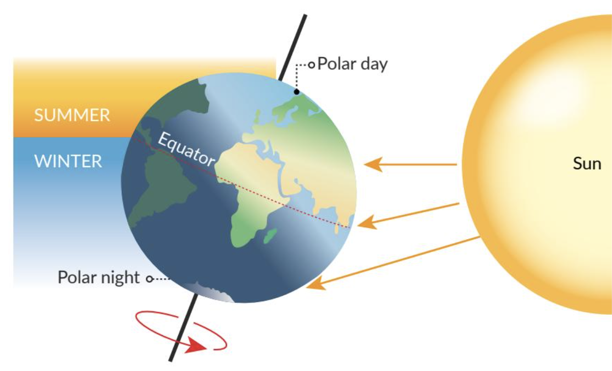
Our planet tilts at an angle of approximately 23.5 degrees on its axis. This tilt has a major impact on how temperature varies across different regions throughout the year. As Earth orbits the Sun, different parts of the planet receive varying amounts of solar radiation during different seasons.
When a hemisphere tilts towards the sun, it experiences summer with warmer temperatures due to more direct sunlight. When the same hemisphere tilts away from the sun, it undergoes winter with cooler temperatures as solar radiation becomes less direct and intense.
Earth's curvature causes uneven heating
The curved surface of our planet means that solar radiation does not strike all areas with equal intensity. At the equator, solar radiation hits the surface most directly and intensely because this region sits at the centre of Earth's curvature. This direct radiation creates consistently higher temperatures in equatorial regions throughout the year.
At the poles, Earth's curvature causes solar radiation to strike at much more oblique angles. This spreading effect means the same amount of solar energy covers a larger area, resulting in less intense heating and consistently colder conditions.
Think of shining a flashlight directly down onto a table versus shining it at an angle. The angled light spreads out over a larger area and appears dimmer - this is exactly what happens with solar radiation at different latitudes on Earth's curved surface.
Latitude determines temperature zones
Latitude, which measures distance north or south of the equator, plays a vital role in temperature variation across the globe.
Tropical zones exist between the Tropic of Cancer and the Tropic of Capricorn near the equator. These areas receive the most direct sunlight throughout the year, creating consistently warm to hot temperatures with minimal seasonal variation.
Temperate zones lie between the tropical and polar regions, including areas like Ireland and much of Europe. These regions experience clear seasonal temperature variations due to changing angles of solar radiation throughout the year. During summer, the sun's rays strike at steeper angles, while winter brings more oblique radiation.
Polar regions near the Arctic and Antarctic remain cold all year round. These areas receive only oblique sunlight, which limits heating effectiveness and creates permanently cold conditions.
Land and sea masses
The presence of land and water bodies significantly affects temperature distribution patterns. These different surface types heat up and cool down at very different rates, creating distinct climate characteristics.
Landmasses change temperature rapidly
Land surfaces heat up and cool down much more quickly than water. During daytime, landmasses absorb and retain heat efficiently, leading to higher daytime temperatures. At night, however, they lose heat rapidly, resulting in cooler night-time temperatures.
Regions located far from the moderating influence of oceans develop continental climates. These areas often experience extreme temperature variations between summer and winter seasons.
Example: Continental Climate in Russia
Interior parts of Russia demonstrate extreme continental climate conditions:
- Summer temperatures can reach over 30°C in cities like Moscow
- Winter temperatures frequently drop below -20°C
- This extreme variation occurs due to distance from oceanic influence
- The temperature range between seasons can exceed 50°C
Sea masses provide temperature stability
Oceans and seas have a stabilising effect on temperature patterns. Water possesses high heat capacity, meaning it can absorb and release heat slowly and steadily. This characteristic helps areas near large water bodies experience milder and more stable temperatures throughout the year.
Regions close to the sea develop maritime climates with moderate and comfortable temperature ranges. Coastal areas of Ireland, for instance, experience less temperature variation between seasons compared to inland areas, thanks to the surrounding Atlantic Ocean's moderating influence.
Water's high heat capacity means it acts like a giant thermal battery - it takes a lot of energy to heat up water, but once heated, it releases that energy slowly and steadily. This is why islands and coastal areas have such stable temperatures compared to continental interiors.
Coastal effects create local variations
Coastal areas can experience distinctive daily temperature patterns. During the day, sea breezes develop when cool air from the ocean moves inland, providing relief from extreme heat. At night, land breezes may occur as cooler air from the land moves towards the coast.
These local wind patterns help moderate coastal temperatures and create more comfortable conditions compared to areas further inland. The differential heating between land and sea surfaces drives these beneficial air circulation patterns.
Ocean currents
Ocean currents act like rivers within the sea, flowing continuously and playing a crucial role in redistributing temperature around Earth's surface. These currents can create both warming and cooling effects on coastal regions, significantly impacting local climate conditions.
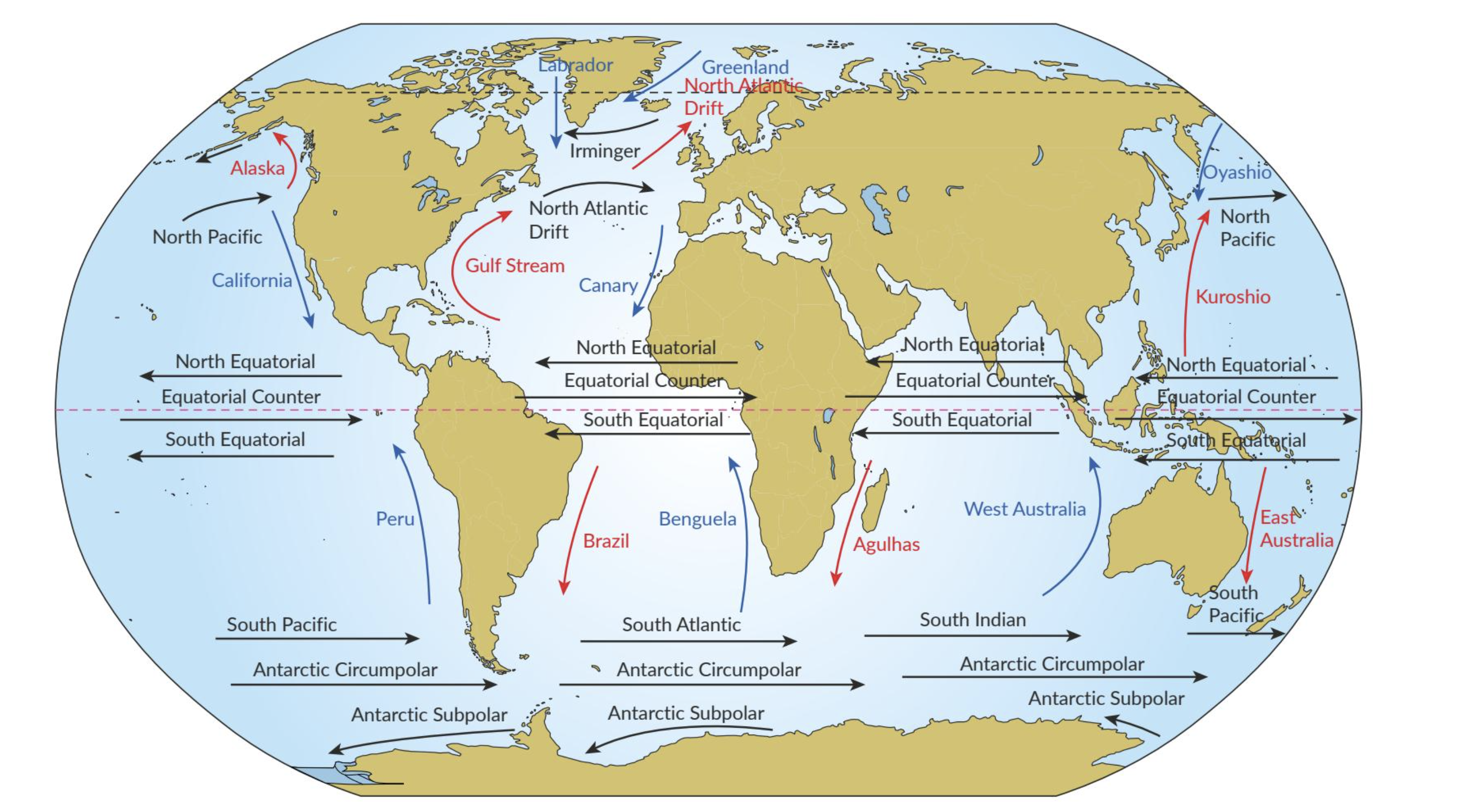
Warm ocean currents transfer heat poleward
Warm ocean currents carry heated water from equatorial regions towards higher latitudes, transferring tropical heat to cooler areas. The Gulf Stream serves as an excellent example of this process. This prominent warm current originates in the Gulf of Mexico and carries warm water north-eastward towards western Europe.
When warm ocean currents flow near coastal areas, they raise local temperatures significantly. The Gulf Stream helps maintain milder conditions across parts of western Europe, including Ireland, making these regions much less susceptible to extreme cold than they would otherwise experience.
Example: The Gulf Stream's Impact on Ireland
The Gulf Stream's warming effect on Ireland is remarkable:
- Without the Gulf Stream, Ireland would have a climate similar to Labrador, Canada
- Labrador sits at the same latitude as Ireland but experiences much colder temperatures
- Ireland's average winter temperature is about 10°C warmer than equivalent latitudes without warm current influence
- This explains why palm trees can grow in southwest Ireland despite its northern latitude
Cold ocean currents provide cooling effects
Cold ocean currents transport chilled water from polar regions towards lower latitudes, creating cooling effects on nearby coastal areas. The California Current exemplifies this process, flowing southward along the western coast of North America.
Cold currents can lower coastal temperatures considerably, making nearby regions cooler than they would be otherwise. These currents also influence local weather patterns and can affect regional precipitation characteristics.
Upwelling and downwelling processes
Upwelling occurs when cold, nutrient-rich water from deeper ocean layers rises to the surface. This process can cool coastal regions while also supporting productive fisheries due to increased nutrient availability.
Downwelling involves surface water sinking to deeper levels, often associated with converging ocean currents. This process can result in warming of coastal waters and affects local marine ecosystems.
Climate variability affects current patterns
Ocean currents can change in strength and position due to natural climate variability, such as El Niño and La Niña events. These variations create profound impacts on regional climates, including significant changes to temperature patterns across affected areas.
Prevailing winds
Prevailing winds represent dominant wind patterns that consistently blow in particular directions over specific regions. These wind systems play a crucial role in influencing temperature distribution across Earth's surface by transporting air masses with different thermal characteristics.
Westerlies moderate mid-latitude temperatures
Westerlies are prevailing winds that blow from west to east in the mid-latitudes, between 30° and 60° latitude in both hemispheres. In Ireland, the south-westerly winds hold particular importance as they bring moist and relatively mild maritime air from the Atlantic Ocean.
Ireland's western location on the edge of the Atlantic Ocean exposes it to these south-westerly winds, creating a maritime climate with mild temperatures throughout the year. The westerlies help moderate temperature extremes and contribute to Ireland's characteristically stable climate conditions.
Example: Ireland's South-Westerly Winds
Ireland's climate is heavily influenced by south-westerly winds:
- These winds travel over the warm Atlantic Ocean before reaching Ireland
- They pick up moisture and mild temperatures from the ocean
- Result: Ireland experiences mild, wet winters and cool, damp summers
- Average temperature range is only about 10°C between winter and summer
Trade winds affect equatorial regions
Trade winds are consistent easterly winds that blow from east to west near the equator, roughly between 0° and 30° latitude in both hemispheres. The north-east trade winds in the northern hemisphere blow from the north-east towards the south-west, affecting regions like the Caribbean.
These winds transport warm, tropical air towards equatorial regions, contributing to higher temperatures in affected areas. Conversely, descending air in subtropical high-pressure zones associated with trade winds can create arid or desert conditions in certain regions.
Polar easterlies bring cold conditions
Polar easterlies are cold prevailing winds that blow from polar high-pressure zones towards the mid-latitudes, generally between 60° and 90° latitude. These winds affect regions such as Siberia in the northern hemisphere and Antarctica in the southern hemisphere.
Polar easterlies transport cold air masses from polar regions to mid-latitudes, contributing to lower temperatures in affected areas during certain seasons. These winds can significantly impact regional temperature patterns, especially during winter months.
The global wind pattern creates a system where warm air moves towards the poles and cold air moves towards the equator, helping to redistribute temperature around the planet. This circulation is driven by the uneven heating of Earth's surface.
Seasonal variability affects wind patterns
Prevailing winds can show seasonal variations due to Earth's axial tilt and changing pressure patterns. For example, during summer in the northern hemisphere, the westerlies may shift poleward, affecting temperature distribution patterns across different regions.
Altitude
Altitude, or elevation above sea level, represents a crucial factor that significantly influences temperature distribution. As elevation increases, several important temperature-related changes occur that affect local and regional climate conditions.
Temperature decreases with altitude
The most noticeable impact of increasing altitude is a consistent drop in temperature. For every 100 metres gained in elevation, average temperature typically decreases by approximately 0.6°C. This principle becomes evident when comparing warmer temperatures at sea level along coastlines to cooler temperatures experienced in upland areas.
In Ireland, this altitude effect is clearly visible when comparing coastal temperatures to those experienced in elevated areas such as the Wicklow Mountains. As altitude increases, air becomes less dense and holds less heat, leading to progressively cooler conditions and sometimes even alpine or polar climates at high elevations.
Example: Temperature Change with Altitude in Ireland
The Wicklow Mountains demonstrate altitude's effect on temperature:
- Dublin (sea level): Average July temperature 16°C
- Lugnaquilla Peak (925m): Average July temperature approximately 10°C
- Temperature difference: About 6°C cooler at the peak
- This follows the rule: 925m ÷ 100m × 0.6°C = 5.6°C difference
Temperature inversion can occur
Occasionally, temperature inversion occurs when a layer of warm air traps cooler air near Earth's surface. This phenomenon happens more commonly in valleys and basins, where cold air becomes trapped beneath a stable layer of warmer air above.
Example: Temperature Inversion at Glendalough
Glendalough in Co. Wicklow is known for experiencing temperature inversion events:
- Cold air settles in the valley during calm nights
- Surrounding hilltops can be 5-10°C warmer than the valley floor
- This creates cooler temperatures in the valley compared to higher areas
- The phenomenon is most common during clear, still winter nights
Temperature inversion reverses the normal pattern where temperature decreases with altitude. During inversion events, valleys can actually be colder than surrounding hillsides, creating unique local climate conditions.
Microclimates develop from altitude variations
Altitude can create microclimates - small, localised climate variations within larger regions. These microclimates can exhibit unique temperature patterns influenced by local topography and elevation changes.
Example: Microclimates in The Burren
The Burren in Co. Clare contains microclimates where:
- Sheltered limestone pavements create warmer pockets
- These areas support Mediterranean plants despite Ireland's cool climate
- Temperature can vary by several degrees over distances of just a few hundred metres
- The limestone absorbs heat during the day and releases it slowly at night
Key Points to Remember:
-
Five main factors control temperature distribution: tilt/curvature/latitude, land/sea masses, ocean currents, prevailing winds, and altitude
-
Earth's 23.5-degree tilt creates seasonal temperature variations, while its curvature causes equatorial regions to be warmer than polar areas
-
Maritime climates (near seas) have stable temperatures, while continental climates (inland areas) experience extreme temperature variations
-
Warm ocean currents like the Gulf Stream carry heat towards poles, while cold currents transport cooling effects towards lower latitudes
-
Temperature decreases by 0.6°C for every 100 metres of altitude gained, creating cooler conditions in mountainous areas