Radial Survey (HSC SSCE Mathematics Standard): Revision Notes
Radial Survey
What is a radial survey?
A radial survey is a surveying technique used to map and measure a piece of land shaped like a polygon. The method involves establishing a central point within or near the land and drawing lines that radiate outward to each corner of the polygon.
The key measurements taken in a radial survey are:
- The length of each radial line (the distance from the central point to each corner)
- The angles between the radial lines at the central point
The central point is usually labelled (for origin). This point serves as the reference from which all measurements are made.
Key vocabulary:
- Radial lines: Lines drawn from the central point to the corners of the polygon
- Origin (): The central reference point from which all measurements are taken
- Polygon: A closed shape with straight sides (the boundary of the land being surveyed)
How to conduct a radial survey
To perform a compass radial survey in the field, you need the following equipment:
- A plane table (a surveyor's flat table)
- A large sheet of paper
- A compass
- Measuring equipment (such as a tape measure)
Step-by-step process
The process for conducting a radial survey follows these steps:
- Position a plane table with a large sheet of paper in the centre of the field you want to survey.
- Mark a point near the middle of the paper and label it (the origin).
- Draw a line on the paper from point that represents your line of sight to the first corner of the land boundary. This is your first radial line.
- Measure the actual distance from your position (where is marked on the ground) to that corner of the land boundary.
- Mark off this distance on the radial line you drew, using an appropriate scale. For example, if you use a scale where metre on the ground equals centimetre on paper, and the corner is metres away, you would mark a point centimetres from along the radial line.
- Repeat steps 3 to 5 for every corner of the piece of land. You will draw a radial line from to each corner and mark the scaled distance on each line.
- Draw boundary lines connecting the ends of the radial lines. These lines represent the actual boundaries of the land.
- Use a compass to measure the angles at point between each pair of adjacent radial lines.
Point (the origin) can be positioned in the centre of the land, on its boundary, or even outside the land area, depending on what works best for the survey. This flexibility makes radial surveys practical for various field conditions.
Calculating area using a radial survey
Once you have completed a radial survey, you can calculate the area of the land by dividing it into triangles. Each triangle is formed by the origin and two adjacent corners of the polygon.
Using the sine rule for area
When you know two sides of a triangle and the angle between them (called the included angle), you can find the area using the sine rule for area:
where:
- and are the lengths of two sides
- is the included angle between those sides
Worked Example: Finding Area from a Radial Survey
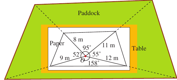
Question: The diagram shows a radial survey of a triangular piece of land. What is the area of ? Give your answer in square metres correct to one decimal place.
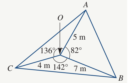
The diagram shows:
- m
- m
- m
Solution:
The triangular land is divided into three smaller triangles: , , and . Each triangle has two known sides (the radial lines) and the included angle at .
Step 1: Find the area of
Using the sine rule for area:
Step 2: Find the area of
Step 3: Find the area of
Step 4: Add the three areas together
Exam tip: When calculating the total area of a polygon using a radial survey, always divide it into triangles first. Then calculate each triangle's area separately and add them together at the end.
Calculating distances using a radial survey
When working with compass bearings in a radial survey, you can find unknown distances between corners of the land using the cosine rule.
Working with compass bearings
Compass bearings (also called true bearings, marked with a T) are measured clockwise from north. For example:
- means clockwise from north
- means clockwise from north
To find angles at the origin between radial lines, you need to work out the angle between the bearings.
The cosine rule
When you know two sides of a triangle and the included angle, you can find the third side using the cosine rule:
where:
- and are the known sides
- is the included angle
- is the unknown side you want to find
Worked Example: Finding Distances and Perimeter
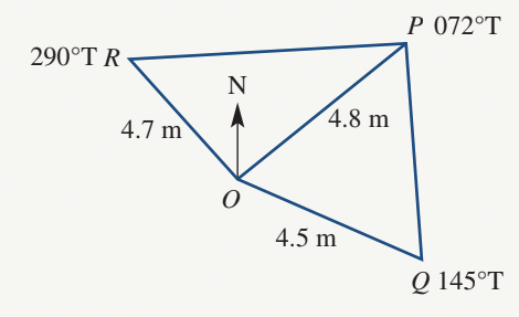
Question: A compass radial survey for a field is shown in the diagram. The radial distances and bearings are:
- m at bearing
- m at bearing
- m at bearing
Find: a) The size of b) The size of c) The length of (to 2 decimal places) d) The length of (to 2 decimal places) e) The perimeter of the field (to 3 significant figures)
Solution:
Part a: Finding
To find the angle at between points and , subtract the bearing of from the bearing of :
Part b: Finding
First, work out the angle between and north:
This means is anticlockwise from north (or equivalently, to the west of north).
Point is clockwise from north.
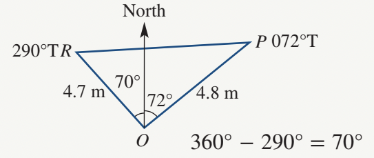
Therefore, the angle between the two radial lines is:
Part c: Finding length
In , we know:
- m
- m
Using the cosine rule where is the unknown side:
Part d: Finding length
In , we know:
- m
- m
Using the cosine rule:
Part e: Finding the perimeter
The field is a quadrilateral with four sides: , , , and .
Wait, let me reconsider. Looking at the diagram, the field has sides , , plus the radial lines aren't all sides. Actually, the field perimeter is:
Actually, reviewing the solution: the four sides of the field are two of the radial distances. Let me recalculate:
Converting bearings to angles: When bearings are greater than , they extend beyond the south direction. To find the angle from north in these cases, subtract from . This gives you the angle measured anticlockwise from north.
Key Points to Remember:
-
A radial survey maps polygonal land by measuring distances and angles from a central origin point to all corners of the polygon.
-
To find the area of land from a radial survey, divide the polygon into triangles and use the sine area formula: .
-
To find unknown distances between corners, use the cosine rule: .
-
When working with compass bearings, angles at the origin are found by taking the difference between bearings (for bearings less than apart) or by working with respect to north for bearings greater than .
-
The origin can be positioned anywhere—in the centre of the land, on its boundary, or even outside the land area.