The Mid-Latitudes: Large-Scale Weather Systems (Leaving Cert Geography): Revision Notes
The mid-latitudes: large-scale weather systems
Introduction to mid-latitude weather patterns
The mid-latitudes represent a unique atmospheric zone where tropical and polar air masses collide. This region experiences highly variable and unpredictable weather patterns that change dramatically both seasonally and daily. The constant interaction between contrasting air masses creates the dynamic weather conditions characteristic of temperate regions like Ireland.
The mid-latitude zone, roughly between 30° and 60° latitude, serves as Earth's primary battleground between contrasting air masses, making it one of the most meteorologically active regions on the planet.
Two primary atmospheric disturbances dominate this region:
- Mid-latitude depressions (low-pressure systems)
- Mid-latitude anticyclones (high-pressure systems)
Mid-latitude depressions
What are mid-latitude depressions?
Mid-latitude depressions, also called extratropical cyclones, are extensive low-pressure weather systems that play a crucial role in determining climate and weather patterns across temperate zones. These systems are characterised by atmospheric pressure below normal levels and serve as the primary mechanism for weather variability in regions like Ireland.
Formation and development
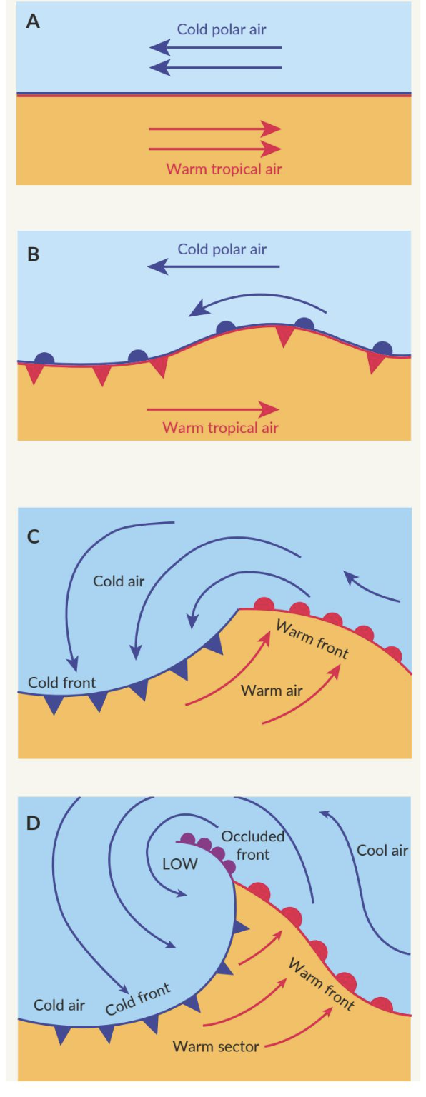
These weather systems develop along the polar front, which acts as the boundary zone separating contrasting air masses. When warm tropical air encounters cold polar air, the temperature difference creates instability in the atmosphere. The warmer, less dense air is forced upward over the colder, denser air mass, initiating the formation of a depression.
Understanding Frontal Systems
The structure of a developing depression features two distinct frontal systems with very different characteristics:
- Warm front: Where warm air advances over cold air, typically producing steady rainfall followed by clearer, milder conditions
- Cold front: Where cold air undercuts warm air, usually generating more intense but shorter-duration precipitation with a subsequent temperature drop
Life cycle and movement patterns
Mid-latitude depressions progress through three distinct stages during their existence:
The Three Stages of Depression Development
Initial development: A wave-like disturbance forms along the polar front, creating a low-pressure centre as contrasting air masses begin to interact.
Maturation: The warm and cold fronts become increasingly pronounced, and the depression intensifies, reaching maximum strength during this phase.
Dissipation: The system gradually weakens as it moves away from its energy source, eventually losing the temperature contrast that sustains it.
These systems typically travel from west to east across the mid-latitudes, driven by prevailing westerly winds. Their speed and trajectory can be influenced by various atmospheric factors, including the jet stream and topographical features such as mountain ranges.
Weather impacts
Mid-latitude depressions are responsible for much of Ireland's changeable weather conditions. They bring sequences of rain, wind, and occasionally severe storm conditions. The passage of these systems often results in rapid weather changes as different frontal zones move through an area.
Case Study: Storm Babet (2023)
A notable example occurred in 2023 when Storm Babet delivered over 90 millimetres of rainfall within just 36 hours to parts of Ireland, demonstrating the significant precipitation potential of these systems. This event highlighted how quickly mid-latitude depressions can deliver substantial amounts of precipitation in very short timeframes.
Mid-latitude anticyclones
Characteristics and formation
Mid-latitude anticyclones are high-pressure weather systems that form when air in the upper atmosphere descends towards Earth's surface. This process occurs when warm air rises at the equator, moves poleward, cools, and then sinks back towards the surface. As this air descends, it warms without gaining or losing heat to the environment, creating increased surface pressure.
These systems feature a high-pressure centre where atmospheric pressure reaches maximum values. Due to the Coriolis effect caused by Earth's rotation, air within anticyclones moves in a clockwise direction in the northern hemisphere.
The clockwise circulation pattern in anticyclones (in the Northern Hemisphere) inhibits cloud formation and reduces wind speeds, typically resulting in calm, clear weather conditions. This is the opposite of the counterclockwise circulation found in depressions.
Movement and development
Similar to depressions, anticyclones generally move from west to east across the mid-latitudes, guided by upper-level atmospheric winds. The jet stream and geographical features can influence their speed and direction of movement.
The life cycle includes development from areas of high pressure, maturation into well-defined systems, and eventual dissipation as the system moves and weakens over time.
Weather effects in Ireland
Anticyclones significantly influence Irish weather patterns, often providing welcome relief from the typically wet climate. During summer months, these systems can produce warm, sunny conditions with elevated temperatures, sometimes leading to heatwave conditions. The Azores High, a semi-permanent anticyclone in the North Atlantic, frequently extends its influence towards Ireland during these periods.
Seasonal Variations in Anticyclonic Weather
In winter, anticyclones can generate cold, frosty conditions with clear skies. The clear nighttime conditions allow significant temperature drops, often resulting in frost formation. Fog commonly develops under these conditions, particularly during morning hours.
Extreme weather events
While generally associated with stable conditions, anticyclones can sometimes contribute to extreme weather patterns. During summer, prolonged anticyclonic conditions may lead to drought and water shortages. Conversely, persistent high pressure in winter can cause extended cold spells.
Case Study: September 2023 Omega System Heatwave
A significant example occurred in September 2023 when Ireland experienced an unusual heatwave caused by an omega system. This omega high-pressure pattern became trapped between low-pressure systems, with tropical storms pushing the high-pressure system over Ireland and the UK.
The jet stream moved northward and formed an omega-blocking pattern, causing temperatures to reach 28 degrees Celsius and prompting a three-day yellow high temperature weather warning. This demonstrated how anticyclones can create extreme weather when they become blocked in unusual positions.
Key Points to Remember:
- Mid-latitude depressions are low-pressure systems that bring changeable weather including rain, wind, and storms to Ireland
- These systems form at the polar front where warm tropical and cold polar air masses meet
- Anticyclones are high-pressure systems that typically bring stable, clear weather conditions
- Both systems generally move from west to east driven by prevailing winds and the jet stream
- Recent examples include Storm Babet (2023) bringing heavy rainfall and the September 2023 heatwave caused by an omega high-pressure system